Heathfield elevation
Heathfield (England, East Sussex), United Kingdom elevation is 148 meters and Heathfield elevation in feet is 486 ft above sea level [src 1]. Heathfield is a populated place (feature code) with elevation that is 76 meters (249 ft) bigger than average city elevation in United Kingdom.
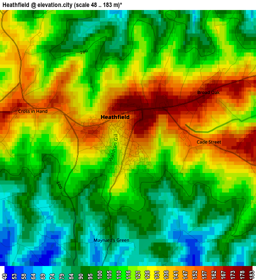
Below is the Elevation map of Heathfield, which displays elevation range with different colors. Scale of the first map is from 48 to 183 m (157 to 600 ft) with average elevation of 112.4 meters (=369 ft) [note 1]
These maps also provides idea of topography and contour of this city, they are displayed at different zoom levels. More info about maps, scale and edge coordinates you can find below images.
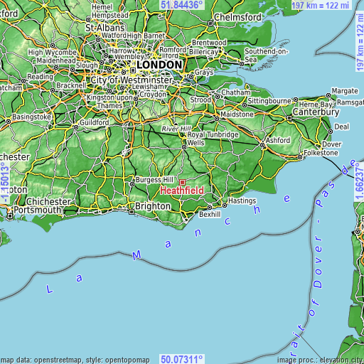
| \ | Map #1 | Topo.Map |
| Scale [m] | 48..183 m | × |
| Scale [ft] | 157..600 ft | × |
| Average | 112.4 m = 369 ft | × |
| Width | 6.15 km = 3.8 mi | 196.9 km = 122.3 mi |
| Height | 6.15 km = 3.8 mi | 196.9 km = 122.3 mi |
| ↑Max Latitude | 50.994847° | 51.84436° |
| Latitude at center | 50.96718° | 50.96718° |
| ↓Min Latitude | 50.939497° | 50.07311° |
| ← Min Longitude | 0.212175° | -1.15013° |
| Longitude center | 0.25612° | 0.25612° |
| →Max Longitude | 0.300065° | 1.66237° |
Nearby cities:
Cities around Heathfield sort by population:
• Crowborough elevation 201 m
12.3 km,  328°
328°
• Hailsham 28 m
11.7 km,  179°
179°
• Uckfield 19 m
11.2 km,  271°
271°
• Wadhurst 152 m
12.1 km,  28°
28°
• Horam 70 m
3.6 km,  193°
193°
• Town Row 129 m
9.7 km,  350°
350°
• Buxted 62 m
8.9 km,  286°
286°
• Ticehurst 111 m
13.8 km,  50°
50°
• Bodle Street 54 m
8.6 km,  134°
134°
• Burwash 92 m
9.6 km,  69°
69°
• Ninfield 75 m
14.9 km, 127°
• Herstmonceux 50 m
9.8 km,  151°
151°
Multilingual:
 En español:
Heathfield elevación 148 m.
 En France:
Heathfield élévation 148 m.
 Auf Deutsch:
Heathfield höhe über dem Meeresspiegel ist 148 m.

Sources and notes:
- [note 1] Map square and city borders are not equal. Map elevation data is calculated only from area inside that square.
- [src 1] Elevation data from geonames database provided with same terms of usage.
- [src 2] The elevation map of Heathfield is generated using elevation data from NASA's 3 arcsec (90m) resolution SRTM data.
- [src 3] Base (background) map © OpenStreetMap contributors tiles are generated by Geofabrik and OpenTopoMap.
Copyright & License:
This Heathfield Elevation Map is licensed under CC BY-SA. You may reuse any part from this page, if you give a proper credit by linking to this URL:
 More info on terms of use page.