Hook elevation
Hook (England, Hampshire), United Kingdom elevation is 82 meters and Hook elevation in feet is 269 ft above sea level [src 1]. Hook is a populated place (feature code) with elevation that is 10 meters (33 ft) bigger than average city elevation in United Kingdom.
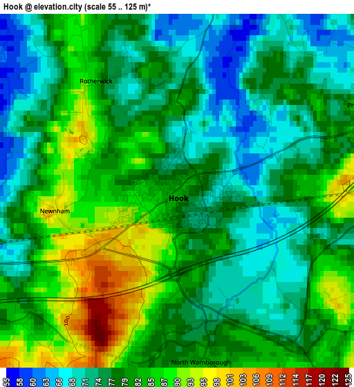
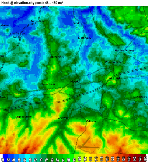
Below is the Elevation map of Hook, which displays elevation range with different colors. Scale of the first map is from 55 to 125 m (180 to 410 ft) with average elevation of 79.2 meters (=260 ft) [note 1]
These maps also provides idea of topography and contour of this city, they are displayed at different zoom levels. More info about maps, scale and edge coordinates you can find below images.
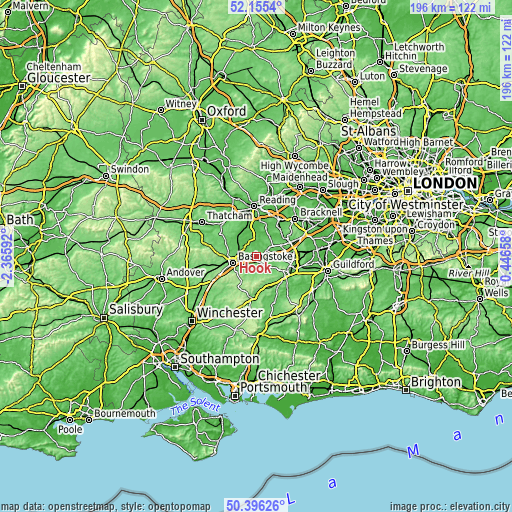
| \ | Map #1 | Map #2 | Topo.Map |
| Scale [m] | 55..125 m | 48..150 m | × |
| Scale [ft] | 180..410 ft | 157..492 ft | × |
| Average | 79.2 m = 260 ft | 81.3 m = 267 ft | × |
| Width | 6.11 km = 3.8 mi | 12.22 km = 7.6 mi | 195.6 km = 121.5 mi |
| Height | 6.11 km = 3.8 mi | 12.22 km = 7.6 mi | 195.6 km = 121.5 mi |
| ↑Max Latitude | 51.311728° | 51.339189° | 52.1554° |
| Latitude at center | 51.28425° | 51.28425° | 51.28425° |
| ↓Min Latitude | 51.256756° | 51.229245° | 50.39626° |
| ← Min Longitude | -1.003615° | -1.047561° | -2.36592° |
| Longitude center | -0.95967° | -0.95967° | -0.95967° |
| →Max Longitude | -0.915725° | -0.871779° | 0.44658° |
Nearby cities:
Cities around Hook sort by population:
• Basingstoke elevation 96 m
9.2 km,  254°
254°
• Fleet 74 m
8.8 km,  90°
90°
• Yateley 61 m
11.1 km,  54°
54°
• Long Sutton 125 m
7.3 km,  170°
170°
• Hartley Wintney 70 m
4.7 km,  62°
62°
• Bramley 60 m
8.4 km,  304°
304°
• Old Basing 79 m
5.5 km, 249°
• Odiham 96 m
3.6 km,  157°
157°
• Eversley 49 m
9.2 km,  32°
32°
• Crondall 89 m
8.8 km,  130°
130°
• Sherborne St John 82 m
10.8 km,  277°
277°
• Swallowfield 44 m
10.5 km,  0°
0°
Multilingual:
 En español:
Hook elevación 82 m.
 En France:
Hook élévation 82 m.


Sources and notes:
- [note 1] Map square and city borders are not equal. Map elevation data is calculated only from area inside that square.
- [src 1] Elevation data from geonames database provided with same terms of usage.
- [src 2] The elevation map of Hook is generated using elevation data from NASA's 3 arcsec (90m) resolution SRTM data.
- [src 3] Base (background) map © OpenStreetMap contributors tiles are generated by Geofabrik and OpenTopoMap.
Copyright & License:
This Hook Elevation Map is licensed under CC BY-SA. You may reuse any part from this page, if you give a proper credit by linking to this URL:
 More info on terms of use page.