Yateley elevation
Yateley (England, Hampshire), United Kingdom elevation is 61 meters and Yateley elevation in feet is 200 ft above sea level [src 1]. Yateley is a populated place (feature code) with elevation that is 11 meters (36 ft) smaller than average city elevation in United Kingdom.
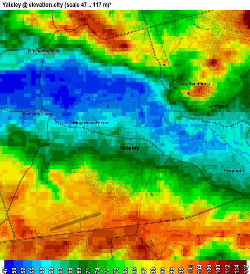
Below is the Elevation map of Yateley, which displays elevation range with different colors. Scale of the first map is from 47 to 117 m (154 to 384 ft) with average elevation of 78 meters (=256 ft) [note 1]
These maps also provides idea of topography and contour of this city, they are displayed at different zoom levels. More info about maps, scale and edge coordinates you can find below images.
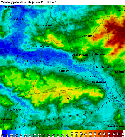
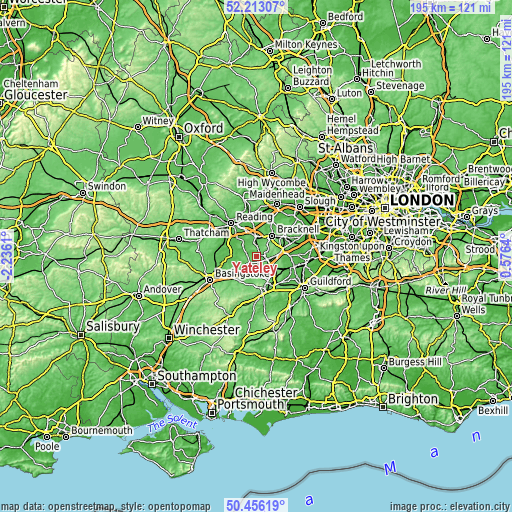
| \ | Map #1 | Map #2 | Topo.Map |
| Scale [m] | 47..117 m | 45..141 m | × |
| Scale [ft] | 154..384 ft | 148..463 ft | × |
| Average | 78 m = 256 ft | 75.1 m = 246 ft | × |
| Width | 6.1 km = 3.8 mi | 12.21 km = 7.6 mi | 195.3 km = 121.4 mi |
| Height | 6.1 km = 3.8 mi | 12.21 km = 7.6 mi | 195.3 km = 121.4 mi |
| ↑Max Latitude | 51.370492° | 51.397919° | 52.21307° |
| Latitude at center | 51.34305° | 51.34305° | 51.34305° |
| ↓Min Latitude | 51.315591° | 51.288116° | 50.45619° |
| ← Min Longitude | -0.873795° | -0.917741° | -2.2361° |
| Longitude center | -0.82985° | -0.82985° | -0.82985° |
| →Max Longitude | -0.785905° | -0.741959° | 0.5764° |
Nearby cities:
Cities around Yateley sort by population:
• Bracknell elevation 81 m
9.6 km,  35°
35°
• Farnborough 69 m
7.5 km,  136°
136°
• Wokingham 72 m
7.6 km,  356°
356°
• Fleet 74 m
6.6 km,  182°
182°
• Camberley 84 m
6.1 km,  96°
96°
• Crowthorne 97 m
4 km, 40°
• Frimley 64 m
6.6 km,  116°
116°
• Hartley Wintney 70 m
6.6 km,  228°
228°
• Eversley 49 m
4.3 km,  286°
286°
• Finchampstead 68 m
2.8 km,  317°
317°
• Barkham 71 m
6.9 km,  332°
332°
• Sandhurst 66 m
3 km,  82°
82°
Multilingual:
 En español:
Yateley elevación 61 m.
 En France:
Yateley élévation 61 m.


Sources and notes:
- [note 1] Map square and city borders are not equal. Map elevation data is calculated only from area inside that square.
- [src 1] Elevation data from geonames database provided with same terms of usage.
- [src 2] The elevation map of Yateley is generated using elevation data from NASA's 3 arcsec (90m) resolution SRTM data.
- [src 3] Base (background) map © OpenStreetMap contributors tiles are generated by Geofabrik and OpenTopoMap.
Copyright & License:
This Yateley Elevation Map is licensed under CC BY-SA. You may reuse any part from this page, if you give a proper credit by linking to this URL:
 More info on terms of use page.