Iver elevation
Iver (England, Buckinghamshire), United Kingdom elevation is 25 meters and Iver elevation in feet is 82 ft above sea level [src 1]. Iver is a populated place (feature code) with elevation that is 47 meters (154 ft) smaller than average city elevation in United Kingdom.
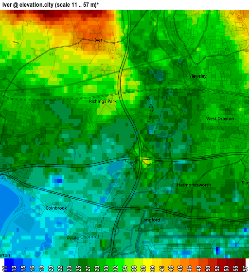
Below is the Elevation map of Iver, which displays elevation range with different colors. Scale of the first map is from 11 to 57 m (36 to 187 ft) with average elevation of 28.1 meters (=92 ft) [note 1]
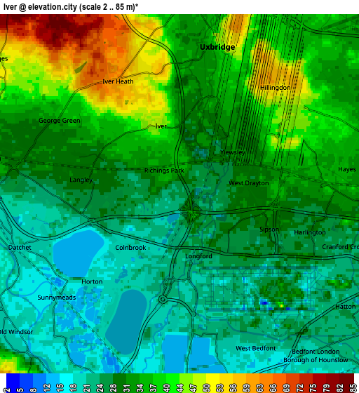
These maps also provides idea of topography and contour of this city, they are displayed at different zoom levels. More info about maps, scale and edge coordinates you can find below images.
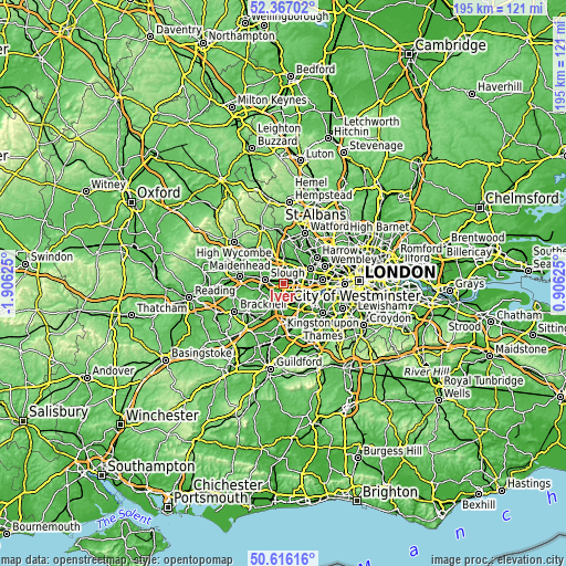
| \ | Map #1 | Map #2 | Topo.Map |
| Scale [m] | 11..57 m | 2..85 m | × |
| Scale [ft] | 36..187 ft | 7..279 ft | × |
| Average | 28.1 m = 92 ft | 31.4 m = 103 ft | × |
| Width | 6.08 km = 3.8 mi | 12.17 km = 7.6 mi | 194.7 km = 121 mi |
| Height | 6.08 km = 3.8 mi | 12.17 km = 7.6 mi | 194.7 km = 121 mi |
| ↑Max Latitude | 51.527348° | 51.55468° | 52.36702° |
| Latitude at center | 51.5° | 51.5° | 51.5° |
| ↓Min Latitude | 51.472635° | 51.445254° | 50.61616° |
| ← Min Longitude | -0.543945° | -0.587891° | -1.90625° |
| Longitude center | -0.5° | -0.5° | -0.5° |
| →Max Longitude | -0.456055° | -0.412109° | 0.90625° |
Nearby cities:
Cities around Iver sort by population:
• Slough elevation 33 m
6.7 km,  279°
279°
• Staines 16 m
7.7 km,  183°
183°
• Hayes 39 m
5.6 km,  71°
71°
• Windsor 49 m
7.2 km,  255°
255°
• West Drayton 29 m
2.3 km,  90°
90°
• Iver Heath 53 m
4.2 km,  342°
342°
• Old Windsor 19 m
7.6 km,  232°
232°
• Colnbrook 20 m
2.3 km,  219°
219°
• Datchet 20 m
5.8 km,  251°
251°
• Denham 43 m
7.4 km,  0°
0°
• Horton 19 m
4.2 km, 224°
• Uxbridge 40 m
5.6 km,  12°
12°
Multilingual:
 En español:
Iver elevación 25 m.
 En France:
Iver élévation 25 m.


Sources and notes:
- [note 1] Map square and city borders are not equal. Map elevation data is calculated only from area inside that square.
- [src 1] Elevation data from geonames database provided with same terms of usage.
- [src 2] The elevation map of Iver is generated using elevation data from NASA's 3 arcsec (90m) resolution SRTM data.
- [src 3] Base (background) map © OpenStreetMap contributors tiles are generated by Geofabrik and OpenTopoMap.
Copyright & License:
This Iver Elevation Map is licensed under CC BY-SA. You may reuse any part from this page, if you give a proper credit by linking to this URL:
 More info on terms of use page.