Liphook elevation
Liphook (England, Hampshire), United Kingdom elevation is 110 meters and Liphook elevation in feet is 361 ft above sea level [src 1]. Liphook is a populated place (feature code) with elevation that is 38 meters (125 ft) bigger than average city elevation in United Kingdom.
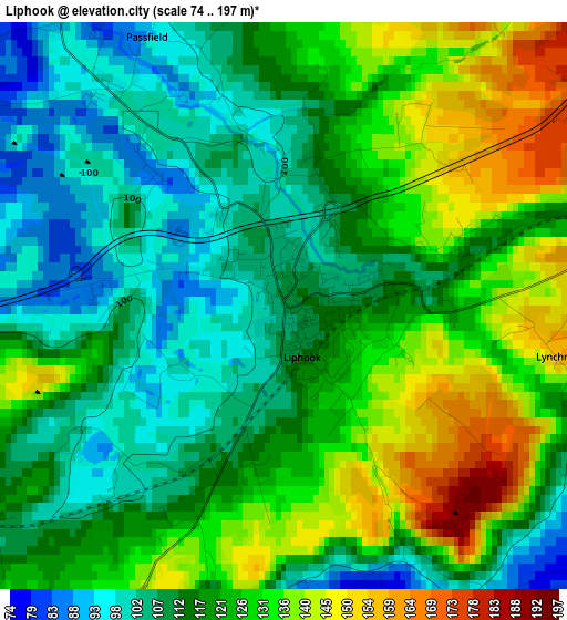
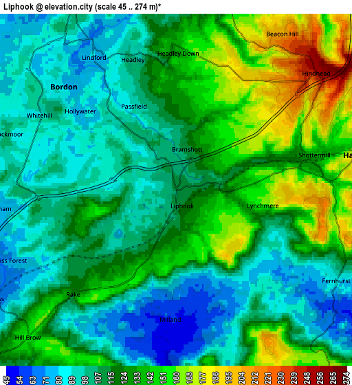
Below is the Elevation map of Liphook, which displays elevation range with different colors. Scale of the first map is from 74 to 197 m (243 to 646 ft) with average elevation of 119.6 meters (=392 ft) [note 1]
These maps also provides idea of topography and contour of this city, they are displayed at different zoom levels. More info about maps, scale and edge coordinates you can find below images.
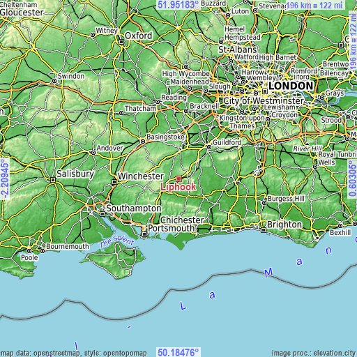
| \ | Map #1 | Map #2 | Topo.Map |
| Scale [m] | 74..197 m | 45..274 m | × |
| Scale [ft] | 243..646 ft | 148..899 ft | × |
| Average | 119.6 m = 392 ft | 119.1 m = 391 ft | × |
| Width | 6.14 km = 3.8 mi | 12.28 km = 7.6 mi | 196.5 km = 122.1 mi |
| Height | 6.14 km = 3.8 mi | 12.28 km = 7.6 mi | 196.5 km = 122.1 mi |
| ↑Max Latitude | 51.104332° | 51.131917° | 51.95183° |
| Latitude at center | 51.07673° | 51.07673° | 51.07673° |
| ↓Min Latitude | 51.049112° | 51.021477° | 50.18476° |
| ← Min Longitude | -0.847145° | -0.891091° | -2.20945° |
| Longitude center | -0.8032° | -0.8032° | -0.8032° |
| →Max Longitude | -0.759255° | -0.715309° | 0.60305° |
Nearby cities:
Cities around Liphook sort by population:
• Bordon elevation 93 m
5.8 km,  314°
314°
• Petersfield 62 m
12.1 km,  228°
228°
• Haslemere 157 m
6.8 km,  77°
77°
• Midhurst 33 m
11.1 km,  156°
156°
• Witley 88 m
13.6 km,  53°
53°
• Liss 63 m
7.3 km,  238°
238°
• Hindhead 252 m
6.4 km, 49°
• Chiddingfold 51 m
13.4 km,  69°
69°
• Fernhurst 83 m
6.7 km,  117°
117°
• Wormley 111 m
12.8 km,  58°
58°
• Churt 111 m
6.9 km,  16°
16°
• South Harting 73 m
13.2 km,  205°
205°
Multilingual:
 En español:
Liphook elevación 110 m.
 En France:
Liphook élévation 110 m.


Sources and notes:
- [note 1] Map square and city borders are not equal. Map elevation data is calculated only from area inside that square.
- [src 1] Elevation data from geonames database provided with same terms of usage.
- [src 2] The elevation map of Liphook is generated using elevation data from NASA's 3 arcsec (90m) resolution SRTM data.
- [src 3] Base (background) map © OpenStreetMap contributors tiles are generated by Geofabrik and OpenTopoMap.
Copyright & License:
This Liphook Elevation Map is licensed under CC BY-SA. You may reuse any part from this page, if you give a proper credit by linking to this URL:
 More info on terms of use page.