Livingston elevation
Livingston (Scotland, West Lothian), United Kingdom elevation is 157 meters and Livingston elevation in feet is 515 ft above sea level [src 1]. Livingston is a seat of a second-order administrative division (feature code) with elevation that is 85 meters (279 ft) bigger than average city elevation in United Kingdom.
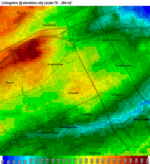
Below is the Elevation map of Livingston, which displays elevation range with different colors. Scale of the first map is from 75 to 204 m (246 to 669 ft) with average elevation of 135.4 meters (=444 ft) [note 1]
These maps also provides idea of topography and contour of this city, they are displayed at different zoom levels. More info about maps, scale and edge coordinates you can find below images.
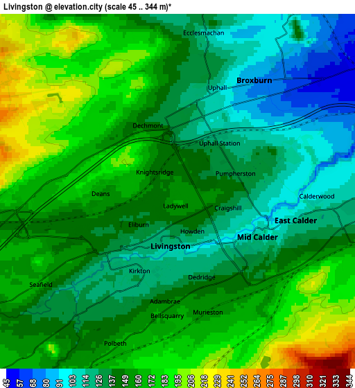
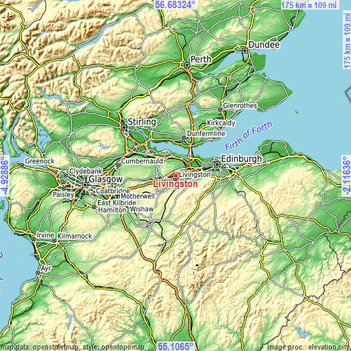
| \ | Map #1 | Map #2 | Topo.Map |
| Scale [m] | 75..204 m | 45..344 m | × |
| Scale [ft] | 246..669 ft | 148..1129 ft | × |
| Average | 135.4 m = 444 ft | 149 m = 489 ft | × |
| Width | 5.48 km = 3.4 mi | 10.96 km = 6.8 mi | 175.3 km = 108.9 mi |
| Height | 5.48 km = 3.4 mi | 10.96 km = 6.8 mi | 175.3 km = 108.9 mi |
| ↑Max Latitude | 55.927508° | 55.95212° | 56.68324° |
| Latitude at center | 55.90288° | 55.90288° | 55.90288° |
| ↓Min Latitude | 55.878237° | 55.853577° | 55.1065° |
| ← Min Longitude | -3.566555° | -3.610501° | -4.92886° |
| Longitude center | -3.52261° | -3.52261° | -3.52261° |
| →Max Longitude | -3.478665° | -3.434719° | -2.11636° |
Nearby cities:
Cities around Livingston sort by population:
• Bathgate elevation 141 m
7.6 km,  269°
269°
• Broxburn 70 m
4.7 km,  42°
42°
• Blackburn 160 m
8 km,  239°
239°
• East Calder 125 m
3.9 km,  108°
108°
• Mid Calder 110 m
2.9 km, 113°
• West Calder 177 m
6.4 km,  207°
207°
• Winchburgh 85 m
7.1 km,  30°
30°
• Polbeth 165 m
5 km,  199°
199°
• Kirknewton 171 m
6.7 km,  104°
104°
• Addiebrownhill 198 m
8.9 km,  221°
221°
• Seafield 155 m
4.9 km, 235°
• Newbridge 62 m
8.4 km,  66°
66°
Multilingual:
 En español:
Livingston elevación 157 m.
 En France:
Livingston élévation 157 m.
 Auf Deutsch:
Livingston höhe über dem Meeresspiegel ist 157 m.

Sources and notes:
- [note 1] Map square and city borders are not equal. Map elevation data is calculated only from area inside that square.
- [src 1] Elevation data from geonames database provided with same terms of usage.
- [src 2] The elevation map of Livingston is generated using elevation data from NASA's 3 arcsec (90m) resolution SRTM data.
- [src 3] Base (background) map © OpenStreetMap contributors tiles are generated by Geofabrik and OpenTopoMap.
Copyright & License:
This Livingston Elevation Map is licensed under CC BY-SA. You may reuse any part from this page, if you give a proper credit by linking to this URL:
 More info on terms of use page.