Long Melford elevation
Long Melford (England, Suffolk), United Kingdom elevation is 36 meters and Long Melford elevation in feet is 118 ft above sea level [src 1]. Long Melford is a populated place (feature code) with elevation that is 36 meters (118 ft) smaller than average city elevation in United Kingdom.
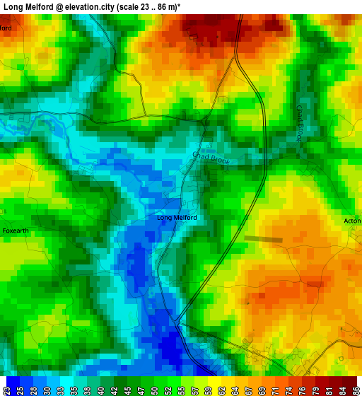
Below is the Elevation map of Long Melford, which displays elevation range with different colors. Scale of the first map is from 23 to 86 m (75 to 282 ft) with average elevation of 50.9 meters (=167 ft) [note 1]
These maps also provides idea of topography and contour of this city, they are displayed at different zoom levels. More info about maps, scale and edge coordinates you can find below images.
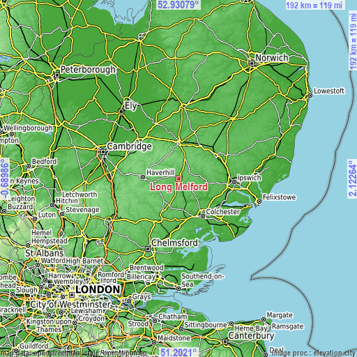
| \ | Map #1 | Topo.Map |
| Scale [m] | 23..86 m | × |
| Scale [ft] | 75..282 ft | × |
| Average | 50.9 m = 167 ft | × |
| Width | 6.01 km = 3.7 mi | 192.2 km = 119.4 mi |
| Height | 6.01 km = 3.7 mi | 192.2 km = 119.4 mi |
| ↑Max Latitude | 52.101812° | 52.93079° |
| Latitude at center | 52.07481° | 52.07481° |
| ↓Min Latitude | 52.047792° | 51.2021° |
| ← Min Longitude | 0.672445° | -0.68986° |
| Longitude center | 0.71639° | 0.71639° |
| →Max Longitude | 0.760335° | 2.12264° |
Nearby cities:
Cities around Long Melford sort by population:
• Sudbury elevation 36 m
4.1 km,  165°
165°
• Halstead 53 m
15.4 km,  200°
200°
• Sible Hedingham 53 m
13.7 km,  218°
218°
• Glemsford 70 m
4.5 km,  314°
314°
• Clare 50 m
9.2 km,  272°
272°
• Kedington 62 m
15.8 km,  277°
277°
• Great Yeldham 55 m
12.4 km,  236°
236°
• Bures Saint Mary 23 m
12.1 km,  160°
160°
• Lavenham 66 m
6.6 km,  55°
55°
• Great Waldingfield 61 m
4.5 km,  118°
118°
• Castle Hedingham 53 m
12.4 km, 220°
• Bildeston 40 m
13.6 km,  74°
74°
Multilingual:
 En español:
Long Melford elevación 36 m.
 En France:
Long Melford élévation 36 m.
 Auf Deutsch:
Long Melford höhe über dem Meeresspiegel ist 36 m.

Sources and notes:
- [note 1] Map square and city borders are not equal. Map elevation data is calculated only from area inside that square.
- [src 1] Elevation data from geonames database provided with same terms of usage.
- [src 2] The elevation map of Long Melford is generated using elevation data from NASA's 3 arcsec (90m) resolution SRTM data.
- [src 3] Base (background) map © OpenStreetMap contributors tiles are generated by Geofabrik and OpenTopoMap.
Copyright & License:
This Long Melford Elevation Map is licensed under CC BY-SA. You may reuse any part from this page, if you give a proper credit by linking to this URL:
 More info on terms of use page.