Longridge elevation
Longridge (England, Lancashire), United Kingdom elevation is 129 meters and Longridge elevation in feet is 423 ft above sea level [src 1]. Longridge is a populated place (feature code) with elevation that is 57 meters (187 ft) bigger than average city elevation in United Kingdom.
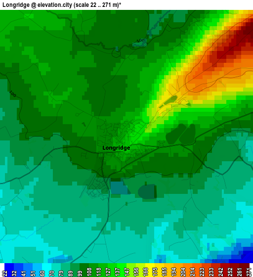
Below is the Elevation map of Longridge, which displays elevation range with different colors. Scale of the first map is from 22 to 271 m (72 to 889 ft) with average elevation of 107.1 meters (=351 ft) [note 1]
These maps also provides idea of topography and contour of this city, they are displayed at different zoom levels. More info about maps, scale and edge coordinates you can find below images.
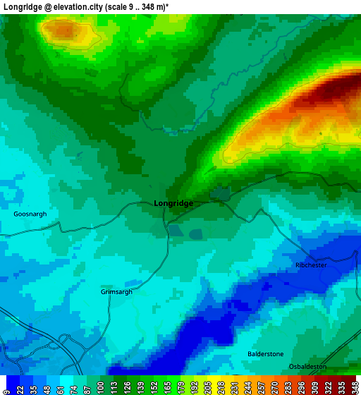
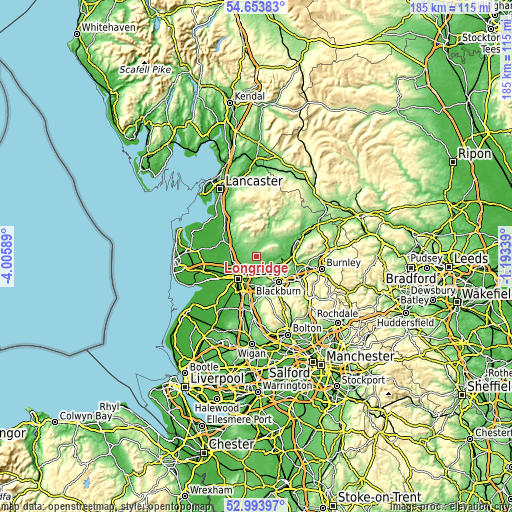
| \ | Map #1 | Map #2 | Topo.Map |
| Scale [m] | 22..271 m | 9..348 m | × |
| Scale [ft] | 72..889 ft | 30..1142 ft | × |
| Average | 107.1 m = 351 ft | 103.2 m = 339 ft | × |
| Width | 5.77 km = 3.6 mi | 11.53 km = 7.2 mi | 184.6 km = 114.7 mi |
| Height | 5.77 km = 3.6 mi | 11.53 km = 7.2 mi | 184.5 km = 114.6 mi |
| ↑Max Latitude | 53.858046° | 53.883957° | 54.65383° |
| Latitude at center | 53.83212° | 53.83212° | 53.83212° |
| ↓Min Latitude | 53.806178° | 53.780219° | 52.99397° |
| ← Min Longitude | -2.643585° | -2.687531° | -4.00589° |
| Longitude center | -2.59964° | -2.59964° | -2.59964° |
| →Max Longitude | -2.555695° | -2.511749° | -1.19339° |
Nearby cities:
Cities around Longridge sort by population:
• Preston elevation 34 m
10.3 km,  221°
221°
• Blackburn 121 m
11.9 km,  140°
140°
• Clitheroe 76 m
13.6 km,  73°
73°
• Great Harwood 125 m
13.6 km,  112°
112°
• Garstang 22 m
13.8 km,  303°
303°
• Rishton 137 m
14.1 km,  120°
120°
• Whalley 51 m
12.7 km,  95°
95°
• Catterall 20 m
12.1 km, 296°
• Langho 110 m
10.3 km, 108°
• Billington 62 m
11.7 km, 98°
• Goosnargh 72 m
4.8 km,  256°
256°
• Waddington 82 m
13.7 km,  62°
62°
Multilingual:
 En español:
Longridge elevación 129 m.
 En France:
Longridge élévation 129 m.
 Auf Deutsch:
Longridge höhe über dem Meeresspiegel ist 129 m.

Sources and notes:
- [note 1] Map square and city borders are not equal. Map elevation data is calculated only from area inside that square.
- [src 1] Elevation data from geonames database provided with same terms of usage.
- [src 2] The elevation map of Longridge is generated using elevation data from NASA's 3 arcsec (90m) resolution SRTM data.
- [src 3] Base (background) map © OpenStreetMap contributors tiles are generated by Geofabrik and OpenTopoMap.
Copyright & License:
This Longridge Elevation Map is licensed under CC BY-SA. You may reuse any part from this page, if you give a proper credit by linking to this URL:
 More info on terms of use page.