Market Bosworth elevation
Market Bosworth (England, Leicestershire), United Kingdom elevation is 134 meters and Market Bosworth elevation in feet is 440 ft above sea level [src 1]. Market Bosworth is a populated place (feature code) with elevation that is 62 meters (203 ft) bigger than average city elevation in United Kingdom.
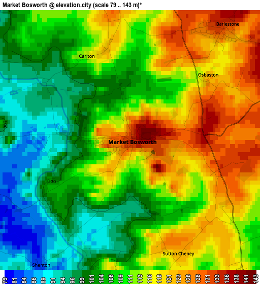
Below is the Elevation map of Market Bosworth, which displays elevation range with different colors. Scale of the first map is from 79 to 143 m (259 to 469 ft) with average elevation of 110.2 meters (=362 ft) [note 1]
These maps also provides idea of topography and contour of this city, they are displayed at different zoom levels. More info about maps, scale and edge coordinates you can find below images.
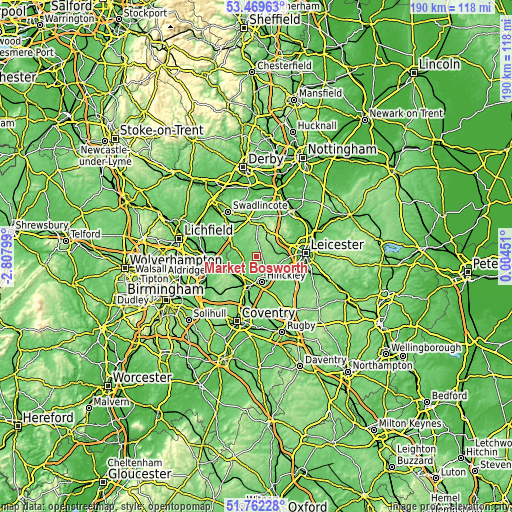
| \ | Map #1 | Topo.Map |
| Scale [m] | 79..143 m | × |
| Scale [ft] | 259..469 ft | × |
| Average | 110.2 m = 362 ft | × |
| Width | 5.93 km = 3.7 mi | 189.8 km = 117.9 mi |
| Height | 5.93 km = 3.7 mi | 189.8 km = 117.9 mi |
| ↑Max Latitude | 52.650948° | 53.46963° |
| Latitude at center | 52.62428° | 52.62428° |
| ↓Min Latitude | 52.597595° | 51.76228° |
| ← Min Longitude | -1.445685° | -2.80799° |
| Longitude center | -1.40174° | -1.40174° |
| →Max Longitude | -1.357795° | 0.00451° |
Nearby cities:
Cities around Market Bosworth sort by population:
• Hinckley elevation 113 m
9.6 km,  169°
169°
• Coalville 161 m
11.1 km,  11°
11°
• Earl Shilton 117 m
7.9 km,  132°
132°
• Ibstock 134 m
6.8 km,  1°
1°
• Markfield 179 m
11.1 km,  50°
50°
• Ratby 101 m
11.2 km,  75°
75°
• Desford 134 m
7.3 km,  88°
88°
• Newbold Verdon 136 m
4.1 km, 81°
• Barlestone 132 m
3.3 km,  39°
39°
• Stoke Golding 113 m
6 km,  186°
186°
• Ravenstone 149 m
10.8 km,  358°
358°
• Bagworth 162 m
6.7 km, 36°
Multilingual:
 En español:
Market Bosworth elevación 134 m.
 En France:
Market Bosworth élévation 134 m.
 Auf Deutsch:
Market Bosworth höhe über dem Meeresspiegel ist 134 m.

Sources and notes:
- [note 1] Map square and city borders are not equal. Map elevation data is calculated only from area inside that square.
- [src 1] Elevation data from geonames database provided with same terms of usage.
- [src 2] The elevation map of Market Bosworth is generated using elevation data from NASA's 3 arcsec (90m) resolution SRTM data.
- [src 3] Base (background) map © OpenStreetMap contributors tiles are generated by Geofabrik and OpenTopoMap.
Copyright & License:
This Market Bosworth Elevation Map is licensed under CC BY-SA. You may reuse any part from this page, if you give a proper credit by linking to this URL:
 More info on terms of use page.