Porlock elevation
Porlock (England, Somerset), United Kingdom elevation is 35 meters and Porlock elevation in feet is 115 ft above sea level [src 1]. Porlock is a populated place (feature code) with elevation that is 37 meters (121 ft) smaller than average city elevation in United Kingdom.
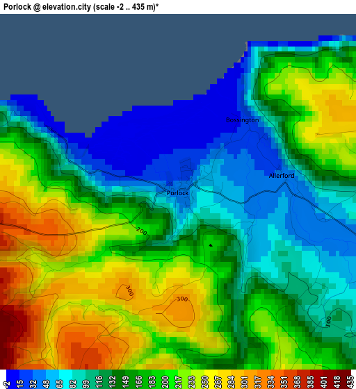
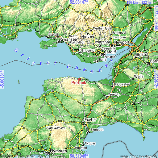
Below is the Elevation map of Porlock, which displays elevation range with different colors. Scale of the first map is from -2 to 435 m (-7 to 1427 ft) with average elevation of 163.8 meters (=537 ft) [note 1]
These maps also provides idea of topography and contour of this city, they are displayed at different zoom levels. More info about maps, scale and edge coordinates you can find below images.
| \ | Map #1 | Topo.Map |
| Scale [m] | -2..435 m | × |
| Scale [ft] | -7..1427 ft | × |
| Average | 163.8 m = 537 ft | × |
| Width | 6.12 km = 3.8 mi | 195.9 km = 121.7 mi |
| Height | 6.12 km = 3.8 mi | 195.9 km = 121.7 mi |
| ↑Max Latitude | 51.236413° | 52.08147° |
| Latitude at center | 51.20889° | 51.20889° |
| ↓Min Latitude | 51.181351° | 50.31945° |
| ← Min Longitude | -3.639505° | -5.00181° |
| Longitude center | -3.59556° | -3.59556° |
| →Max Longitude | -3.551615° | -2.18931° |
Nearby cities:
Cities around Porlock sort by population:
• Llantwit Major elevation 48 m
23.7 km,  18°
18°
• Minehead 29 m
7.9 km,  93°
93°
• Rhoose 46 m
26.1 km,  40°
40°
• South Molton 131 m
27.1 km,  217°
217°
• Cowbridge 35 m
29.9 km, 20°
• Watchet 11 m
18.7 km,  99°
99°
• Combe Martin 30 m
29.8 km,  267°
267°
• Williton 31 m
19.7 km,  105°
105°
• Wiveliscombe 122 m
27.1 km,  133°
133°
• Lynton 186 m
17.3 km,  277°
277°
• Dulverton 144 m
19 km,  170°
170°
• Wick 99 m
25.8 km,  7°
7°
Multilingual:
 En español:
Porlock elevación 35 m.
 En France:
Porlock élévation 35 m.


Sources and notes:
- [note 1] Map square and city borders are not equal. Map elevation data is calculated only from area inside that square.
- [src 1] Elevation data from geonames database provided with same terms of usage.
- [src 2] The elevation map of Porlock is generated using elevation data from NASA's 3 arcsec (90m) resolution SRTM data.
- [src 3] Base (background) map © OpenStreetMap contributors tiles are generated by Geofabrik and OpenTopoMap.
Copyright & License:
This Porlock Elevation Map is licensed under CC BY-SA. You may reuse any part from this page, if you give a proper credit by linking to this URL:
 More info on terms of use page.