Wiveliscombe elevation
Wiveliscombe (England, Somerset), United Kingdom elevation is 122 meters and Wiveliscombe elevation in feet is 400 ft above sea level [src 1]. Wiveliscombe is a populated place (feature code) with elevation that is 50 meters (164 ft) bigger than average city elevation in United Kingdom.
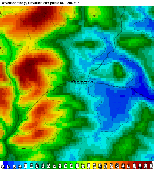
Below is the Elevation map of Wiveliscombe, which displays elevation range with different colors. Scale of the first map is from 68 to 308 m (223 to 1010 ft) with average elevation of 163.7 meters (=537 ft) [note 1]
These maps also provides idea of topography and contour of this city, they are displayed at different zoom levels. More info about maps, scale and edge coordinates you can find below images.
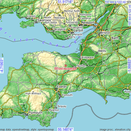
| \ | Map #1 | Topo.Map |
| Scale [m] | 68..308 m | × |
| Scale [ft] | 223..1010 ft | × |
| Average | 163.7 m = 537 ft | × |
| Width | 6.14 km = 3.8 mi | 196.6 km = 122.2 mi |
| Height | 6.14 km = 3.8 mi | 196.6 km = 122.2 mi |
| ↑Max Latitude | 51.069013° | 51.91716° |
| Latitude at center | 51.04139° | 51.04139° |
| ↓Min Latitude | 51.013751° | 50.14874° |
| ← Min Longitude | -3.356725° | -4.71903° |
| Longitude center | -3.31278° | -3.31278° |
| →Max Longitude | -3.268835° | -1.90653° |
Nearby cities:
Cities around Wiveliscombe sort by population:
• Taunton elevation 22 m
15 km,  101°
101°
• Watchet 11 m
15.7 km,  355°
355°
• Willand 63 m
18 km,  192°
192°
• Williton 31 m
13.5 km, 357°
• Bishops Lydeard 56 m
9 km,  77°
77°
• Uffculme 92 m
15.1 km,  183°
183°
• Creech Saint Michael 11 m
19.3 km, 95°
• Hemyock 140 m
15.5 km,  157°
157°
• Nether Stowey 77 m
16.3 km,  41°
41°
• Sampford Peverell 95 m
14.4 km,  199°
199°
• Milverton 71 m
4.7 km,  115°
115°
• Dulverton 144 m
16.6 km,  269°
269°
Multilingual:
 En español:
Wiveliscombe elevación 122 m.
 En France:
Wiveliscombe élévation 122 m.
 Auf Deutsch:
Wiveliscombe höhe über dem Meeresspiegel ist 122 m.

Sources and notes:
- [note 1] Map square and city borders are not equal. Map elevation data is calculated only from area inside that square.
- [src 1] Elevation data from geonames database provided with same terms of usage.
- [src 2] The elevation map of Wiveliscombe is generated using elevation data from NASA's 3 arcsec (90m) resolution SRTM data.
- [src 3] Base (background) map © OpenStreetMap contributors tiles are generated by Geofabrik and OpenTopoMap.
Copyright & License:
This Wiveliscombe Elevation Map is licensed under CC BY-SA. You may reuse any part from this page, if you give a proper credit by linking to this URL:
 More info on terms of use page.