Ripon elevation
Ripon (England, North Yorkshire), United Kingdom elevation is 40 meters and Ripon elevation in feet is 131 ft above sea level [src 1]. Ripon is a populated place (feature code) with elevation that is 32 meters (105 ft) smaller than average city elevation in United Kingdom.
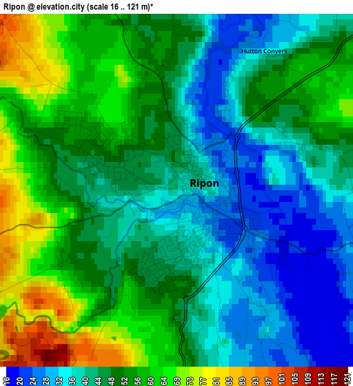
Below is the Elevation map of Ripon, which displays elevation range with different colors. Scale of the first map is from 16 to 121 m (52 to 397 ft) with average elevation of 48.4 meters (=159 ft) [note 1]
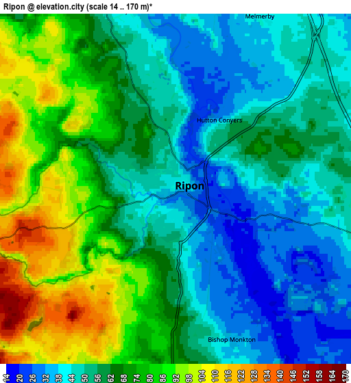
These maps also provides idea of topography and contour of this city, they are displayed at different zoom levels. More info about maps, scale and edge coordinates you can find below images.
| \ | Map #1 | Map #2 | Topo.Map |
| Scale [m] | 16..121 m | 14..170 m | × |
| Scale [ft] | 52..397 ft | 46..558 ft | × |
| Average | 48.4 m = 159 ft | 62.2 m = 204 ft | × |
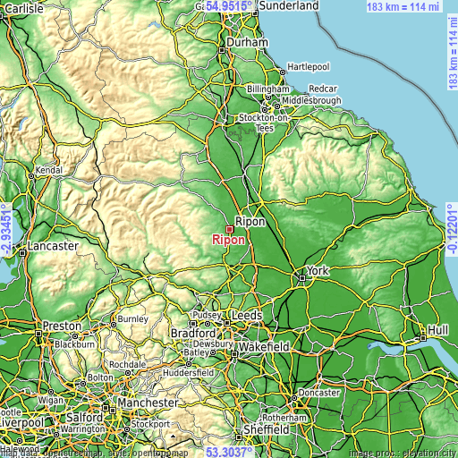
| Width | 5.73 km = 3.6 mi | 11.45 km = 7.1 mi | 183.2 km = 113.8 mi |
| Height | 5.73 km = 3.6 mi | 11.45 km = 7.1 mi | 183.2 km = 113.8 mi |
| ↑Max Latitude | 54.161528° | 54.18725° | 54.9515° |
| Latitude at center | 54.13579° | 54.13579° | 54.13579° |
| ↓Min Latitude | 54.110036° | 54.084266° | 53.3037° |
| ← Min Longitude | -1.572205° | -1.616151° | -2.93451° |
| Longitude center | -1.52826° | -1.52826° | -1.52826° |
| →Max Longitude | -1.484315° | -1.440369° | -0.12201° |
Nearby cities:
Cities around Ripon sort by population:
• Harrogate elevation 127 m
16.1 km,  182°
182°
• Knaresborough 77 m
14.6 km,  164°
164°
• Thirsk 37 m
16.1 km,  47°
47°
• Bedale 43 m
17.4 km,  346°
346°
• Easingwold 32 m
21.9 km,  94°
94°
• Boroughbridge 23 m
9.8 km,  121°
121°
• Pannal 88 m
19.5 km, 181°
• Stainburn 148 m
23.2 km,  194°
194°
• Pateley Bridge 119 m
16.1 km,  249°
249°
• Masham 87 m
12.8 km,  319°
319°
• Spofforth 45 m
20.8 km,  165°
165°
• Linton upon Ouse 15 m
20.7 km, 118°
Multilingual:
 En español:
Ripon elevación 40 m.
 En France:
Ripon élévation 40 m.


Sources and notes:
- [note 1] Map square and city borders are not equal. Map elevation data is calculated only from area inside that square.
- [src 1] Elevation data from geonames database provided with same terms of usage.
- [src 2] The elevation map of Ripon is generated using elevation data from NASA's 3 arcsec (90m) resolution SRTM data.
- [src 3] Base (background) map © OpenStreetMap contributors tiles are generated by Geofabrik and OpenTopoMap.
Copyright & License:
This Ripon Elevation Map is licensed under CC BY-SA. You may reuse any part from this page, if you give a proper credit by linking to this URL:
 More info on terms of use page.