Easingwold elevation
Easingwold (England, North Yorkshire), United Kingdom elevation is 32 meters and Easingwold elevation in feet is 105 ft above sea level [src 1]. Easingwold is a populated place (feature code) with elevation that is 40 meters (131 ft) smaller than average city elevation in United Kingdom.
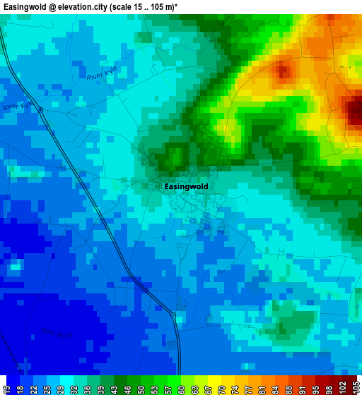
Below is the Elevation map of Easingwold, which displays elevation range with different colors. Scale of the first map is from 15 to 105 m (49 to 344 ft) with average elevation of 34.2 meters (=112 ft) [note 1]
These maps also provides idea of topography and contour of this city, they are displayed at different zoom levels. More info about maps, scale and edge coordinates you can find below images.
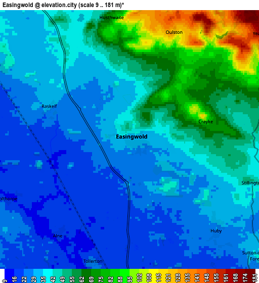
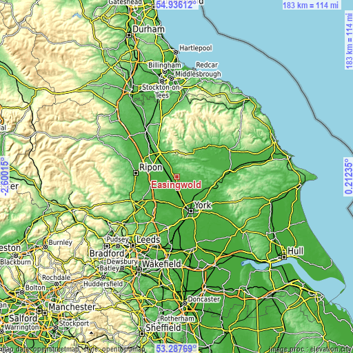
| \ | Map #1 | Map #2 | Topo.Map |
| Scale [m] | 15..105 m | 9..181 m | × |
| Scale [ft] | 49..344 ft | 30..594 ft | × |
| Average | 34.2 m = 112 ft | 42.5 m = 139 ft | × |
| Width | 5.73 km = 3.6 mi | 11.46 km = 7.1 mi | 183.3 km = 113.9 mi |
| Height | 5.73 km = 3.6 mi | 11.46 km = 7.1 mi | 183.3 km = 113.9 mi |
| ↑Max Latitude | 54.145848° | 54.17158° | 54.93612° |
| Latitude at center | 54.1201° | 54.1201° | 54.1201° |
| ↓Min Latitude | 54.094336° | 54.068556° | 53.28769° |
| ← Min Longitude | -1.237845° | -1.281791° | -2.60015° |
| Longitude center | -1.1939° | -1.1939° | -1.1939° |
| →Max Longitude | -1.149955° | -1.106009° | 0.21235° |
Nearby cities:
Cities around Easingwold sort by population:
• Haxby elevation 18 m
14.2 km,  145°
145°
• Thirsk 37 m
15.9 km,  322°
322°
• Strensall 18 m
13.7 km,  130°
130°
• Boroughbridge 23 m
13.9 km,  255°
255°
• Nether Poppleton 12 m
15 km,  169°
169°
• Upper Poppleton 21 m
15.9 km, 170°
• Skelton 19 m
13.9 km,  163°
163°
• Helmsley 55 m
16.6 km,  32°
32°
• Sheriff Hutton 66 m
12.7 km,  105°
105°
• Linton upon Ouse 15 m
9 km,  203°
203°
• Huntington 17 m
16.3 km,  144°
144°
• Wigginton 19 m
13.5 km, 147°
Multilingual:
 En español:
Easingwold elevación 32 m.
 En France:
Easingwold élévation 32 m.
 Auf Deutsch:
Easingwold höhe über dem Meeresspiegel ist 32 m.

Sources and notes:
- [note 1] Map square and city borders are not equal. Map elevation data is calculated only from area inside that square.
- [src 1] Elevation data from geonames database provided with same terms of usage.
- [src 2] The elevation map of Easingwold is generated using elevation data from NASA's 3 arcsec (90m) resolution SRTM data.
- [src 3] Base (background) map © OpenStreetMap contributors tiles are generated by Geofabrik and OpenTopoMap.
Copyright & License:
This Easingwold Elevation Map is licensed under CC BY-SA. You may reuse any part from this page, if you give a proper credit by linking to this URL:
 More info on terms of use page.