Strensall elevation
Strensall (England, City of York), United Kingdom elevation is 18 meters and Strensall elevation in feet is 59 ft above sea level [src 1]. Strensall is a populated place (feature code) with elevation that is 54 meters (177 ft) smaller than average city elevation in United Kingdom.
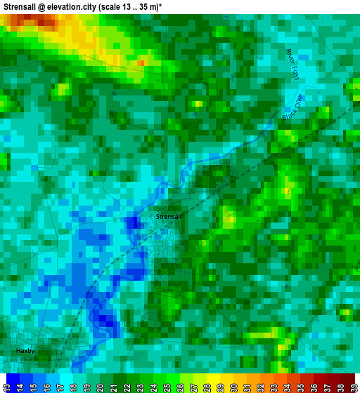
Below is the Elevation map of Strensall, which displays elevation range with different colors. Scale of the first map is from 13 to 35 m (43 to 115 ft) with average elevation of 19.9 meters (=65 ft) [note 1]
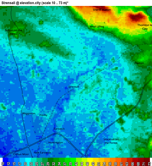
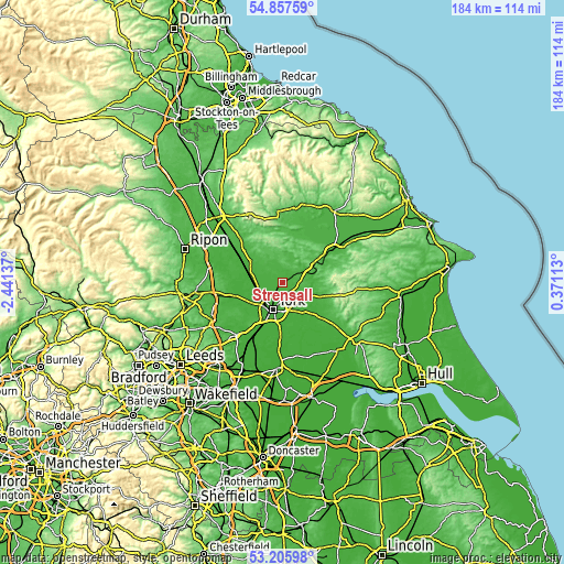
These maps also provides idea of topography and contour of this city, they are displayed at different zoom levels. More info about maps, scale and edge coordinates you can find below images.
| \ | Map #1 | Map #2 | Topo.Map |
| Scale [m] | 13..35 m | 10..73 m | × |
| Scale [ft] | 43..115 ft | 33..240 ft | × |
| Average | 19.9 m = 65 ft | 23.7 m = 78 ft | × |
| Width | 5.74 km = 3.6 mi | 11.48 km = 7.1 mi | 183.6 km = 114.1 mi |
| Height | 5.74 km = 3.6 mi | 11.48 km = 7.1 mi | 183.6 km = 114.1 mi |
| ↑Max Latitude | 54.065788° | 54.091569° | 54.85759° |
| Latitude at center | 54.03999° | 54.03999° | 54.03999° |
| ↓Min Latitude | 54.014176° | 53.988347° | 53.20598° |
| ← Min Longitude | -1.079065° | -1.123011° | -2.44137° |
| Longitude center | -1.03512° | -1.03512° | -1.03512° |
| →Max Longitude | -0.991175° | -0.947229° | 0.37113° |
Nearby cities:
Cities around Strensall sort by population:
• York elevation 17 m
9.7 km,  198°
198°
• Haxby 18 m
3.7 km,  219°
219°
• Stamford Bridge 21 m
9.7 km,  126°
126°
• Nether Poppleton 12 m
9.5 km,  232°
232°
• Upper Poppleton 21 m
10.2 km, 228°
• Skelton 19 m
7.8 km,  235°
235°
• Sheriff Hutton 66 m
5.8 km,  18°
18°
• Murton 18 m
8.4 km,  169°
169°
• Holtby 29 m
7.9 km,  149°
149°
• Heslington 16 m
10.5 km,  185°
185°
• Huntington 17 m
4.6 km, 192°
• Wigginton 19 m
4 km, 231°
Multilingual:
 En español:
Strensall elevación 18 m.
 En France:
Strensall élévation 18 m.
 Auf Deutsch:
Strensall höhe über dem Meeresspiegel ist 18 m.

Sources and notes:
- [note 1] Map square and city borders are not equal. Map elevation data is calculated only from area inside that square.
- [src 1] Elevation data from geonames database provided with same terms of usage.
- [src 2] The elevation map of Strensall is generated using elevation data from NASA's 3 arcsec (90m) resolution SRTM data.
- [src 3] Base (background) map © OpenStreetMap contributors tiles are generated by Geofabrik and OpenTopoMap.
Copyright & License:
This Strensall Elevation Map is licensed under CC BY-SA. You may reuse any part from this page, if you give a proper credit by linking to this URL:
 More info on terms of use page.