Ruabon elevation
Ruabon (Wales, Wrexham), United Kingdom elevation is 120 meters and Ruabon elevation in feet is 394 ft above sea level [src 1]. Ruabon is a populated place (feature code) with elevation that is 48 meters (157 ft) bigger than average city elevation in United Kingdom.
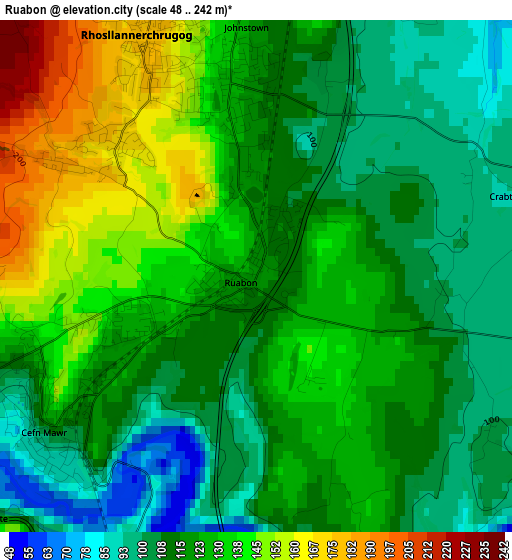
Below is the Elevation map of Ruabon, which displays elevation range with different colors. Scale of the first map is from 48 to 242 m (157 to 794 ft) with average elevation of 122.1 meters (=401 ft) [note 1]
These maps also provides idea of topography and contour of this city, they are displayed at different zoom levels. More info about maps, scale and edge coordinates you can find below images.
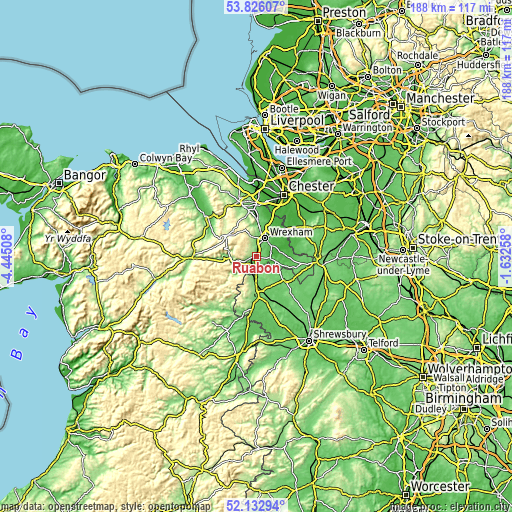
| \ | Map #1 | Topo.Map |
| Scale [m] | 48..242 m | × |
| Scale [ft] | 157..794 ft | × |
| Average | 122.1 m = 401 ft | × |
| Width | 5.88 km = 3.7 mi | 188.3 km = 117 mi |
| Height | 5.88 km = 3.7 mi | 188.2 km = 116.9 mi |
| ↑Max Latitude | 53.014246° | 53.82607° |
| Latitude at center | 52.9878° | 52.9878° |
| ↓Min Latitude | 52.961337° | 52.13294° |
| ← Min Longitude | -3.082775° | -4.44508° |
| Longitude center | -3.03883° | -3.03883° |
| →Max Longitude | -2.994885° | -1.63258° |
Nearby cities:
Cities around Ruabon sort by population:
• Wrexham elevation 87 m
7.3 km,  25°
25°
• Rhosllanerchrugog 175 m
2.8 km,  332°
332°
• Brymbo 248 m
9 km,  348°
348°
• Coedpoeth 205 m
7.5 km, 347°
• Gresford 76 m
11.8 km,  22°
22°
• Chirk 107 m
5.9 km,  192°
192°
• Ellesmere 94 m
12.9 km,  133°
133°
• Llangollen 99 m
9.1 km,  256°
256°
• Gobowen 110 m
10.2 km,  179°
179°
• Whittington 93 m
13 km,  169°
169°
• Marchwiel 64 m
6.6 km,  52°
52°
• Overton 67 m
7.4 km,  108°
108°
Multilingual:
 En español:
Ruabon elevación 120 m.
 En France:
Ruabon élévation 120 m.


Sources and notes:
- [note 1] Map square and city borders are not equal. Map elevation data is calculated only from area inside that square.
- [src 1] Elevation data from geonames database provided with same terms of usage.
- [src 2] The elevation map of Ruabon is generated using elevation data from NASA's 3 arcsec (90m) resolution SRTM data.
- [src 3] Base (background) map © OpenStreetMap contributors tiles are generated by Geofabrik and OpenTopoMap.
Copyright & License:
This Ruabon Elevation Map is licensed under CC BY-SA. You may reuse any part from this page, if you give a proper credit by linking to this URL:
 More info on terms of use page.