Tarvin elevation
Tarvin (England, Cheshire West and Chester), United Kingdom elevation is 40 meters and Tarvin elevation in feet is 131 ft above sea level [src 1]. Tarvin is a populated place (feature code) with elevation that is 32 meters (105 ft) smaller than average city elevation in United Kingdom.
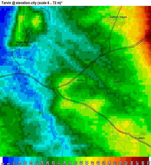
Below is the Elevation map of Tarvin, which displays elevation range with different colors. Scale of the first map is from 6 to 72 m (20 to 236 ft) with average elevation of 30 meters (=98 ft) [note 1]
These maps also provides idea of topography and contour of this city, they are displayed at different zoom levels. More info about maps, scale and edge coordinates you can find below images.
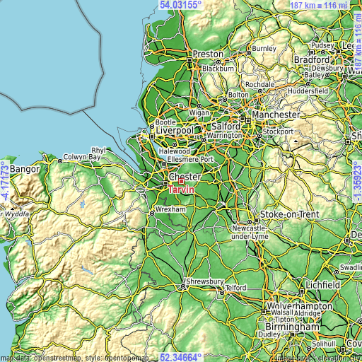
| \ | Map #1 | Topo.Map |
| Scale [m] | 6..72 m | × |
| Scale [ft] | 20..236 ft | × |
| Average | 30 m = 98 ft | × |
| Width | 5.85 km = 3.6 mi | 187.3 km = 116.4 mi |
| Height | 5.85 km = 3.6 mi | 187.3 km = 116.4 mi |
| ↑Max Latitude | 53.223688° | 54.03155° |
| Latitude at center | 53.19737° | 53.19737° |
| ↓Min Latitude | 53.171036° | 52.34664° |
| ← Min Longitude | -2.809425° | -4.17173° |
| Longitude center | -2.76548° | -2.76548° |
| →Max Longitude | -2.721535° | -1.35923° |
Nearby cities:
Cities around Tarvin sort by population:
• Chester elevation 34 m
8.5 km,  264°
264°
• Helsby 19 m
8.5 km,  358°
358°
• Kelsall 85 m
3.7 km,  71°
71°
• Tarporley 98 m
7.7 km,  123°
123°
• Tattenhall 38 m
8.4 km,  180°
180°
• Mickle Trafford 17 m
5.2 km,  301°
301°
• Guilden Sutton 31 m
4.4 km,  285°
285°
• Hoole 25 m
7.4 km,  272°
272°
• Mouldsworth 68 m
4.5 km,  28°
28°
• Oakmere 81 m
8.7 km, 73°
• Elton 13 m
8.4 km,  336°
336°
• Waverton 34 m
4.1 km,  213°
213°
Multilingual:
 En español:
Tarvin elevación 40 m.
 En France:
Tarvin élévation 40 m.


Sources and notes:
- [note 1] Map square and city borders are not equal. Map elevation data is calculated only from area inside that square.
- [src 1] Elevation data from geonames database provided with same terms of usage.
- [src 2] The elevation map of Tarvin is generated using elevation data from NASA's 3 arcsec (90m) resolution SRTM data.
- [src 3] Base (background) map © OpenStreetMap contributors tiles are generated by Geofabrik and OpenTopoMap.
Copyright & License:
This Tarvin Elevation Map is licensed under CC BY-SA. You may reuse any part from this page, if you give a proper credit by linking to this URL:
 More info on terms of use page.