Wilmcote elevation
Wilmcote (England, Warwickshire), United Kingdom elevation is 76 meters and Wilmcote elevation in feet is 249 ft above sea level [src 1]. Wilmcote is a populated place (feature code) with elevation that is 4 meters (13 ft) bigger than average city elevation in United Kingdom.
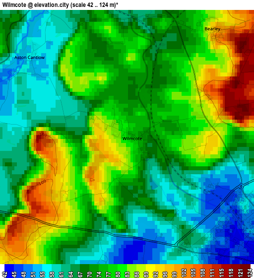
Below is the Elevation map of Wilmcote, which displays elevation range with different colors. Scale of the first map is from 42 to 124 m (138 to 407 ft) with average elevation of 73.7 meters (=242 ft) [note 1]
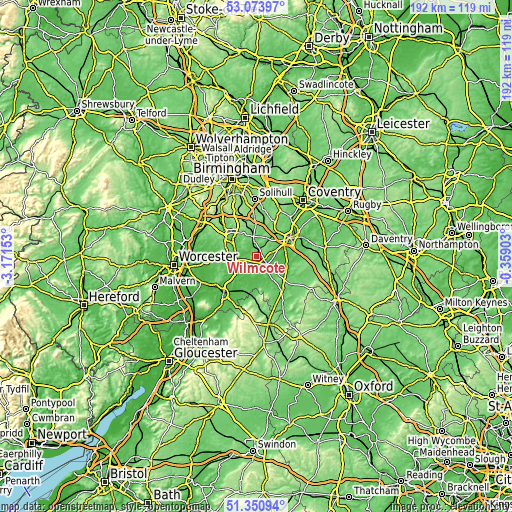
These maps also provides idea of topography and contour of this city, they are displayed at different zoom levels. More info about maps, scale and edge coordinates you can find below images.
| \ | Map #1 | Topo.Map |
| Scale [m] | 42..124 m | × |
| Scale [ft] | 138..407 ft | × |
| Average | 73.7 m = 242 ft | × |
| Width | 5.99 km = 3.7 mi | 191.6 km = 119.1 mi |
| Height | 5.99 km = 3.7 mi | 191.6 km = 119.1 mi |
| ↑Max Latitude | 52.247724° | 53.07397° |
| Latitude at center | 52.22081° | 52.22081° |
| ↓Min Latitude | 52.19388° | 51.35094° |
| ← Min Longitude | -1.809225° | -3.17153° |
| Longitude center | -1.76528° | -1.76528° |
| →Max Longitude | -1.721335° | -0.35903° |
Nearby cities:
Cities around Wilmcote sort by population:
• Stratford-upon-Avon elevation 44 m
5.1 km,  129°
129°
• Warwick 57 m
14.2 km,  60°
60°
• Alcester 45 m
6.9 km,  266°
266°
• Studley 75 m
10.2 km,  302°
302°
• Wellesbourne Mountford 49 m
11.1 km,  106°
106°
• Wellesbourne 50 m
12.2 km,  102°
102°
• Bidford-on-Avon 36 m
8.6 km,  228°
228°
• Bidford-on-avon 39 m
8.6 km, 226°
• Henley in Arden 74 m
7.8 km,  353°
353°
• Astwood Bank 145 m
12.5 km,  290°
290°
• Hatton 100 m
12.6 km,  45°
45°
• Harvington 49 m
14 km, 230°
Multilingual:
 En español:
Wilmcote elevación 76 m.
 En France:
Wilmcote élévation 76 m.


Sources and notes:
- [note 1] Map square and city borders are not equal. Map elevation data is calculated only from area inside that square.
- [src 1] Elevation data from geonames database provided with same terms of usage.
- [src 2] The elevation map of Wilmcote is generated using elevation data from NASA's 3 arcsec (90m) resolution SRTM data.
- [src 3] Base (background) map © OpenStreetMap contributors tiles are generated by Geofabrik and OpenTopoMap.
Copyright & License:
This Wilmcote Elevation Map is licensed under CC BY-SA. You may reuse any part from this page, if you give a proper credit by linking to this URL:
 More info on terms of use page.