Abreschviller elevation
Abreschviller (Grand Est, Moselle), France elevation is 335 meters and Abreschviller elevation in feet is 1099 ft above sea level [src 1]. Abreschviller is a populated place (feature code) with elevation that is 161 meters (528 ft) bigger than average city elevation in France.
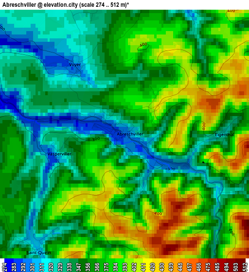
Below is the Elevation map of Abreschviller, which displays elevation range with different colors. Scale of the first map is from 274 to 512 m (899 to 1680 ft) with average elevation of 364.1 meters (=1195 ft) [note 1]
These maps also provides idea of topography and contour of this city, they are displayed at different zoom levels. More info about maps, scale and edge coordinates you can find below images.
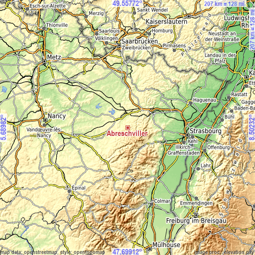
| \ | Map #1 | Topo.Map |
| Scale [m] | 274..512 m | × |
| Scale [ft] | 899..1680 ft | × |
| Average | 364.1 m = 1195 ft | × |
| Width | 6.46 km = 4 mi | 206.7 km = 128.4 mi |
| Height | 6.46 km = 4 mi | 206.6 km = 128.4 mi |
| ↑Max Latitude | 48.666012° | 49.55772° |
| Latitude at center | 48.63698° | 48.63698° |
| ↓Min Latitude | 48.607931° | 47.69912° |
| ← Min Longitude | 7.052125° | 5.68982° |
| Longitude center | 7.09607° | 7.09607° |
| →Max Longitude | 7.140015° | 8.50232° |
Nearby cities:
Cities around Abreschviller sort by population:
• Sarrebourg elevation 270 m
11.3 km,  345°
345°
• Phalsbourg 329 m
18.8 km,  39°
39°
• Dabo 470 m
10.5 km,  79°
79°
• Réding 270 m
12.8 km,  3°
3°
• Schirmeck 345 m
19.4 km,  151°
151°
• Wisches 271 m
19.1 km,  138°
138°
• Cirey-sur-Vezouze 309 m
12.7 km,  240°
240°
• Walscheid 379 m
4.3 km,  65°
65°
• Lutzelhouse 255 m
19.1 km,  132°
132°
• Wangenbourg-Engenthal 434 m
15.4 km,  93°
93°
• Lorquin 272 m
8.1 km,  297°
297°
• Niderviller 263 m
8.5 km,  5°
5°
Multilingual:
 En español:
Abreschviller elevación 335 m.
 En France:
Abreschviller élévation 335 m.
 Auf Deutsch:
Abreschviller höhe über dem Meeresspiegel ist 335 m.

Sources and notes:
- [note 1] Map square and city borders are not equal. Map elevation data is calculated only from area inside that square.
- [src 1] Elevation data from geonames database provided with same terms of usage.
- [src 2] The elevation map of Abreschviller is generated using elevation data from NASA's 3 arcsec (90m) resolution SRTM data.
- [src 3] Base (background) map © OpenStreetMap contributors tiles are generated by Geofabrik and OpenTopoMap.
Copyright & License:
This Abreschviller Elevation Map is licensed under CC BY-SA. You may reuse any part from this page, if you give a proper credit by linking to this URL:
 More info on terms of use page.