Wisches elevation
Wisches (Grand Est, Bas-Rhin), France elevation is 271 meters and Wisches elevation in feet is 889 ft above sea level [src 1]. Wisches is a populated place (feature code) with elevation that is 97 meters (318 ft) bigger than average city elevation in France.
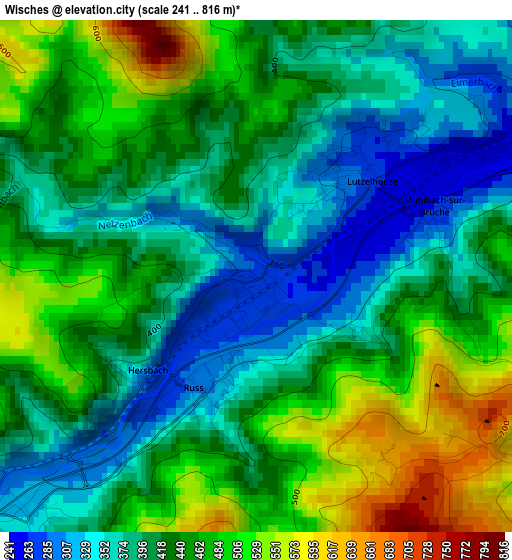
Below is the Elevation map of Wisches, which displays elevation range with different colors. Scale of the first map is from 241 to 816 m (791 to 2677 ft) with average elevation of 428.6 meters (=1406 ft) [note 1]
These maps also provides idea of topography and contour of this city, they are displayed at different zoom levels. More info about maps, scale and edge coordinates you can find below images.
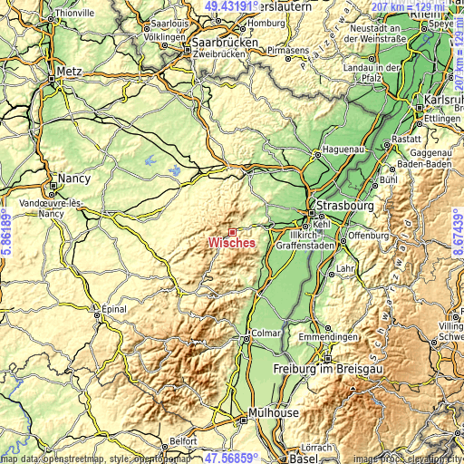
| \ | Map #1 | Topo.Map |
| Scale [m] | 241..816 m | × |
| Scale [ft] | 791..2677 ft | × |
| Average | 428.6 m = 1406 ft | × |
| Width | 6.47 km = 4 mi | 207.2 km = 128.7 mi |
| Height | 6.47 km = 4 mi | 207.2 km = 128.7 mi |
| ↑Max Latitude | 48.537916° | 49.43191° |
| Latitude at center | 48.50881° | 48.50881° |
| ↓Min Latitude | 48.479688° | 47.56859° |
| ← Min Longitude | 7.224195° | 5.86189° |
| Longitude center | 7.26814° | 7.26814° |
| →Max Longitude | 7.312085° | 8.67439° |
Nearby cities:
Cities around Wisches sort by population:
• La Broque elevation 316 m
5.5 km,  223°
223°
• Schirmeck 345 m
4.6 km,  231°
231°
• Rothau 345 m
7.3 km, 217°
• Lutzelhouse 255 m
2 km,  45°
45°
• Still 215 m
11 km,  65°
65°
• Oberhaslach 279 m
6.6 km, 45°
• Gresswiller 195 m
12.5 km,  76°
76°
• Urmatt 244 m
4.7 km,  63°
63°
• Dinsheim-sur-Bruche 202 m
12.3 km, 72°
• Russ 403 m
1.6 km,  205°
205°
• Niederhaslach 250 m
6.7 km, 55°
• Grendelbruch 519 m
4.4 km,  114°
114°
Multilingual:
 En español:
Wisches elevación 271 m.
 En France:
Wisches élévation 271 m.


Sources and notes:
- [note 1] Map square and city borders are not equal. Map elevation data is calculated only from area inside that square.
- [src 1] Elevation data from geonames database provided with same terms of usage.
- [src 2] The elevation map of Wisches is generated using elevation data from NASA's 3 arcsec (90m) resolution SRTM data.
- [src 3] Base (background) map © OpenStreetMap contributors tiles are generated by Geofabrik and OpenTopoMap.
Copyright & License:
This Wisches Elevation Map is licensed under CC BY-SA. You may reuse any part from this page, if you give a proper credit by linking to this URL:
 More info on terms of use page.