Aigre elevation
Aigre (Nouvelle-Aquitaine, Charente), France elevation is 66 meters and Aigre elevation in feet is 217 ft above sea level [src 1]. Aigre is a populated place (feature code) with elevation that is 108 meters (354 ft) smaller than average city elevation in France.
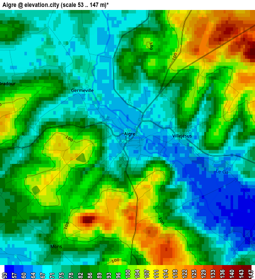
Below is the Elevation map of Aigre, which displays elevation range with different colors. Scale of the first map is from 53 to 147 m (174 to 482 ft) with average elevation of 85.9 meters (=282 ft) [note 1]
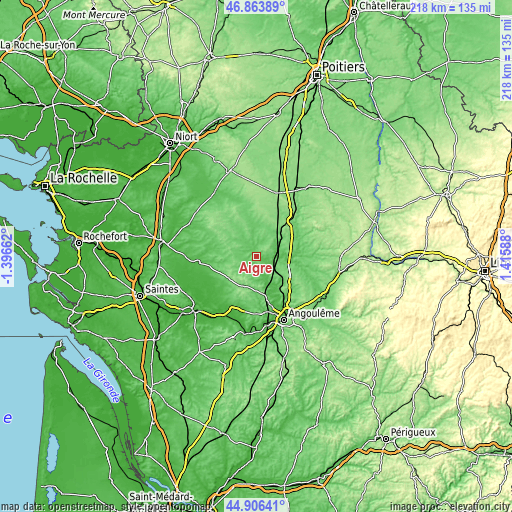
These maps also provides idea of topography and contour of this city, they are displayed at different zoom levels. More info about maps, scale and edge coordinates you can find below images.
| \ | Map #1 | Topo.Map |
| Scale [m] | 53..147 m | × |
| Scale [ft] | 174..482 ft | × |
| Average | 85.9 m = 282 ft | × |
| Width | 6.8 km = 4.2 mi | 217.7 km = 135.3 mi |
| Height | 6.8 km = 4.2 mi | 217.6 km = 135.2 mi |
| ↑Max Latitude | 45.924347° | 46.86389° |
| Latitude at center | 45.89377° | 45.89377° |
| ↓Min Latitude | 45.863176° | 44.90641° |
| ← Min Longitude | -0.034315° | -1.39662° |
| Longitude center | 0.00963° | 0.00963° |
| →Max Longitude | 0.053575° | 1.41588° |
Nearby cities:
Cities around Aigre sort by population:
• Saint-Yrieix-sur-Charente elevation 85 m
24.8 km,  160°
160°
• Champniers 79 m
25 km,  142°
142°
• Ruffec 110 m
20.9 km,  44°
44°
• Brie 119 m
24.9 km,  133°
133°
• Chef-Boutonne 95 m
24.7 km,  345°
345°
• Rouillac 111 m
14.3 km,  203°
203°
• Mansle 68 m
13.3 km,  98°
98°
• Vars 52 m
17.1 km,  148°
148°
• Balzac 32 m
23.1 km, 158°
• Saint-Amant-de-Boixe 68 m
14.4 km, 137°
• Villefagnan 119 m
14.1 km,  22°
22°
• Asnières-sur-Nouère 99 m
19.9 km,  170°
170°
Multilingual:
 En español:
Aigre elevación 66 m.
 En France:
Aigre élévation 66 m.


Sources and notes:
- [note 1] Map square and city borders are not equal. Map elevation data is calculated only from area inside that square.
- [src 1] Elevation data from geonames database provided with same terms of usage.
- [src 2] The elevation map of Aigre is generated using elevation data from NASA's 3 arcsec (90m) resolution SRTM data.
- [src 3] Base (background) map © OpenStreetMap contributors tiles are generated by Geofabrik and OpenTopoMap.
Copyright & License:
This Aigre Elevation Map is licensed under CC BY-SA. You may reuse any part from this page, if you give a proper credit by linking to this URL:
 More info on terms of use page.