Ruffec elevation
Ruffec (Nouvelle-Aquitaine, Charente), France elevation is 110 meters and Ruffec elevation in feet is 361 ft above sea level [src 1]. Ruffec is a populated place (feature code) with elevation that is 64 meters (210 ft) smaller than average city elevation in France.
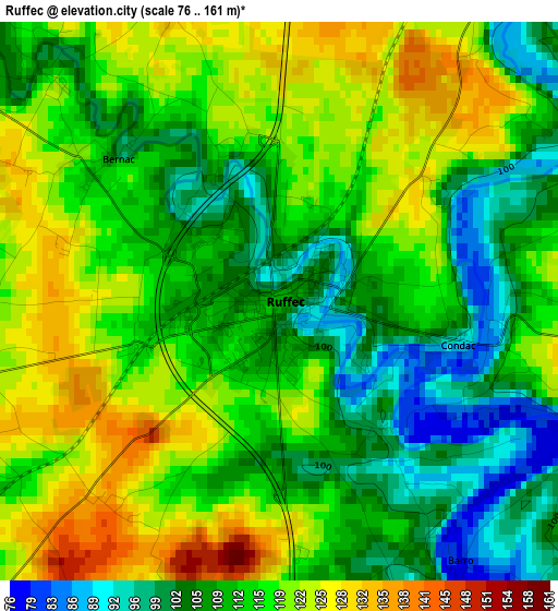
Below is the Elevation map of Ruffec, which displays elevation range with different colors. Scale of the first map is from 76 to 161 m (249 to 528 ft) with average elevation of 113.8 meters (=373 ft) [note 1]
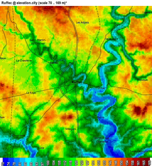
These maps also provides idea of topography and contour of this city, they are displayed at different zoom levels. More info about maps, scale and edge coordinates you can find below images.
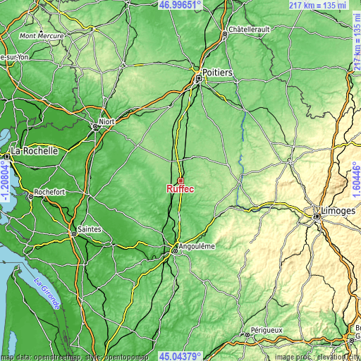
| \ | Map #1 | Map #2 | Topo.Map |
| Scale [m] | 76..161 m | 70..169 m | × |
| Scale [ft] | 249..528 ft | 230..554 ft | × |
| Average | 113.8 m = 373 ft | 119.7 m = 393 ft | × |
| Width | 6.78 km = 4.2 mi | 13.57 km = 8.4 mi | 217.1 km = 134.9 mi |
| Height | 6.79 km = 4.2 mi | 13.57 km = 8.4 mi | 217.1 km = 134.9 mi |
| ↑Max Latitude | 46.059273° | 46.089759° | 46.99651° |
| Latitude at center | 46.02877° | 46.02877° | 46.02877° |
| ↓Min Latitude | 45.99825° | 45.967714° | 45.04379° |
| ← Min Longitude | 0.154265° | 0.110319° | -1.20804° |
| Longitude center | 0.19821° | 0.19821° | 0.19821° |
| →Max Longitude | 0.242155° | 0.286101° | 1.60446° |
Nearby cities:
Cities around Ruffec sort by population:
• Civray elevation 140 m
15.2 km,  29°
29°
• Chef-Boutonne 95 m
22.5 km,  293°
293°
• Mansle 68 m
17.1 km,  184°
184°
• Sauzé-Vaussais 144 m
13.6 km,  328°
328°
• Savigné 136 m
17.3 km, 33°
• Nanteuil-en-Vallée 109 m
10.1 km,  107°
107°
• Charroux 140 m
20.4 km,  50°
50°
• Chaunay 133 m
20 km,  352°
352°
• Aigre 66 m
20.9 km,  224°
224°
• Saint-Claud 156 m
25.4 km,  125°
125°
• Villefagnan 119 m
9.4 km,  258°
258°
• Champagne-Mouton 144 m
16.9 km,  104°
104°
Multilingual:
 En español:
Ruffec elevación 110 m.
 En France:
Ruffec élévation 110 m.


Sources and notes:
- [note 1] Map square and city borders are not equal. Map elevation data is calculated only from area inside that square.
- [src 1] Elevation data from geonames database provided with same terms of usage.
- [src 2] The elevation map of Ruffec is generated using elevation data from NASA's 3 arcsec (90m) resolution SRTM data.
- [src 3] Base (background) map © OpenStreetMap contributors tiles are generated by Geofabrik and OpenTopoMap.
Copyright & License:
This Ruffec Elevation Map is licensed under CC BY-SA. You may reuse any part from this page, if you give a proper credit by linking to this URL:
 More info on terms of use page.