Rouillac elevation
Rouillac (Nouvelle-Aquitaine, Charente), France elevation is 111 meters and Rouillac elevation in feet is 364 ft above sea level [src 1]. Rouillac is a populated place (feature code) with elevation that is 63 meters (207 ft) smaller than average city elevation in France.
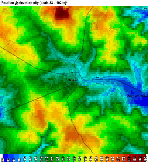
Below is the Elevation map of Rouillac, which displays elevation range with different colors. Scale of the first map is from 83 to 192 m (272 to 630 ft) with average elevation of 129.6 meters (=425 ft) [note 1]
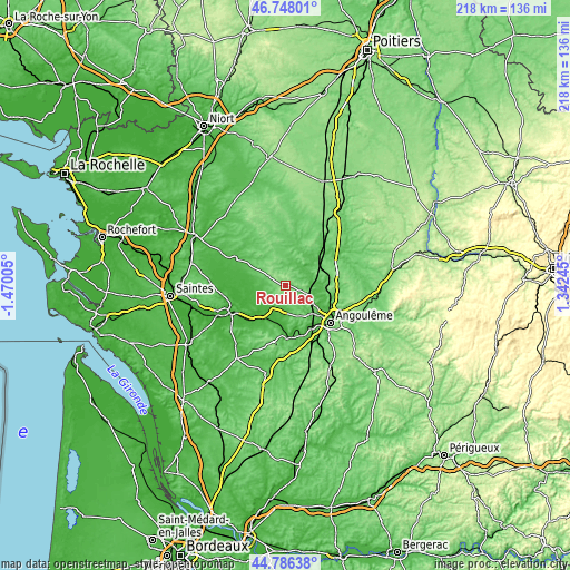
These maps also provides idea of topography and contour of this city, they are displayed at different zoom levels. More info about maps, scale and edge coordinates you can find below images.
| \ | Map #1 | Topo.Map |
| Scale [m] | 83..192 m | × |
| Scale [ft] | 272..630 ft | × |
| Average | 129.6 m = 425 ft | × |
| Width | 6.82 km = 4.2 mi | 218.1 km = 135.5 mi |
| Height | 6.82 km = 4.2 mi | 218.1 km = 135.5 mi |
| ↑Max Latitude | 45.806462° | 46.74801° |
| Latitude at center | 45.77582° | 45.77582° |
| ↓Min Latitude | 45.745161° | 44.78638° |
| ← Min Longitude | -0.107745° | -1.47005° |
| Longitude center | -0.0638° | -0.0638° |
| →Max Longitude | -0.019855° | 1.34245° |
Nearby cities:
Cities around Rouillac sort by population:
• Saint-Yrieix-sur-Charente elevation 85 m
17.4 km,  126°
126°
• Jarnac 30 m
13.5 km,  219°
219°
• Vars 52 m
14.7 km,  95°
95°
• Balzac 32 m
16.3 km,  121°
121°
• Saint-Saturnin 73 m
15 km,  143°
143°
• Aigre 66 m
14.3 km,  23°
23°
• Saint-Amant-de-Boixe 68 m
15.6 km,  80°
80°
• Chassors 43 m
14.6 km,  234°
234°
• Saint-Même-les-Carrières 44 m
15.5 km,  205°
205°
• Asnières-sur-Nouère 99 m
11 km, 126°
• Hiersac 74 m
13.1 km,  157°
157°
• Nercillac 13 m
15.9 km,  245°
245°
Multilingual:
 En español:
Rouillac elevación 111 m.
 En France:
Rouillac élévation 111 m.
 Auf Deutsch:
Rouillac höhe über dem Meeresspiegel ist 111 m.

Sources and notes:
- [note 1] Map square and city borders are not equal. Map elevation data is calculated only from area inside that square.
- [src 1] Elevation data from geonames database provided with same terms of usage.
- [src 2] The elevation map of Rouillac is generated using elevation data from NASA's 3 arcsec (90m) resolution SRTM data.
- [src 3] Base (background) map © OpenStreetMap contributors tiles are generated by Geofabrik and OpenTopoMap.
Copyright & License:
This Rouillac Elevation Map is licensed under CC BY-SA. You may reuse any part from this page, if you give a proper credit by linking to this URL:
 More info on terms of use page.