Arcis-sur-Aube elevation
Arcis-sur-Aube (Grand Est, Département de l'Aube), France elevation is 97 meters and Arcis-sur-Aube elevation in feet is 318 ft above sea level [src 1]. Arcis-sur-Aube is a populated place (feature code) with elevation that is 77 meters (253 ft) smaller than average city elevation in France.
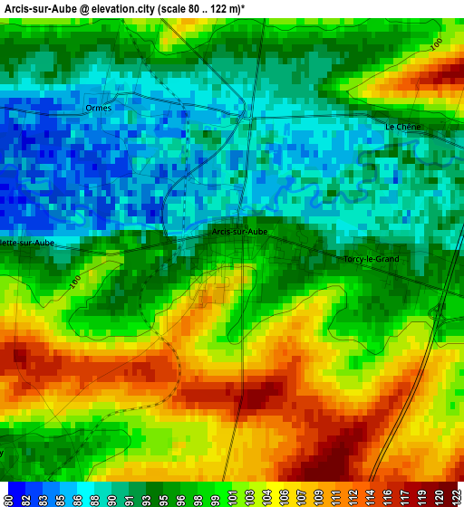
Below is the Elevation map of Arcis-sur-Aube, which displays elevation range with different colors. Scale of the first map is from 80 to 122 m (262 to 400 ft) with average elevation of 97.7 meters (=321 ft) [note 1]
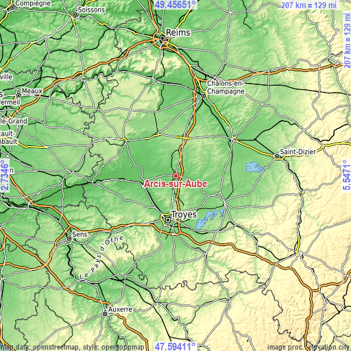
These maps also provides idea of topography and contour of this city, they are displayed at different zoom levels. More info about maps, scale and edge coordinates you can find below images.
| \ | Map #1 | Topo.Map |
| Scale [m] | 80..122 m | × |
| Scale [ft] | 262..400 ft | × |
| Average | 97.7 m = 321 ft | × |
| Width | 6.47 km = 4 mi | 207.1 km = 128.7 mi |
| Height | 6.47 km = 4 mi | 207.1 km = 128.7 mi |
| ↑Max Latitude | 48.562961° | 49.45651° |
| Latitude at center | 48.53387° | 48.53387° |
| ↓Min Latitude | 48.504762° | 47.59411° |
| ← Min Longitude | 4.096905° | 2.7346° |
| Longitude center | 4.14085° | 4.14085° |
| →Max Longitude | 4.184795° | 5.5471° |
Nearby cities:
Cities around Arcis-sur-Aube sort by population:
• Troyes elevation 105 m
26.2 km,  188°
188°
• La Chapelle-Saint-Luc 107 m
25.2 km,  197°
197°
• Pont-Sainte-Marie 104 m
24.2 km, 188°
• Saint-Lyé 96 m
21.5 km,  209°
209°
• Saint-Parres-aux-Tertres 115 m
26.3 km,  183°
183°
• Mailly-le-Camp 132 m
15.5 km,  19°
19°
• Sainte-Maure 111 m
21.6 km, 196°
• Creney-près-Troyes 122 m
22.3 km, 181°
• Maizières-la-Grande-Paroisse 74 m
26.3 km,  264°
264°
• Méry-sur-Seine 83 m
18.6 km, 261°
• Piney 119 m
23.7 km,  143°
143°
• Payns 92 m
20.7 km,  215°
215°
Multilingual:
 En español:
Arcis-sur-Aube elevación 97 m.
 En France:
Arcis-sur-Aube élévation 97 m.
 Auf Deutsch:
Arcis-sur-Aube höhe über dem Meeresspiegel ist 97 m.

Sources and notes:
- [note 1] Map square and city borders are not equal. Map elevation data is calculated only from area inside that square.
- [src 1] Elevation data from geonames database provided with same terms of usage.
- [src 2] The elevation map of Arcis-sur-Aube is generated using elevation data from NASA's 3 arcsec (90m) resolution SRTM data.
- [src 3] Base (background) map © OpenStreetMap contributors tiles are generated by Geofabrik and OpenTopoMap.
Copyright & License:
This Arcis-sur-Aube Elevation Map is licensed under CC BY-SA. You may reuse any part from this page, if you give a proper credit by linking to this URL:
 More info on terms of use page.