Piney elevation
Piney (Grand Est, Département de l'Aube), France elevation is 119 meters and Piney elevation in feet is 390 ft above sea level [src 1]. Piney is a populated place (feature code) with elevation that is 55 meters (180 ft) smaller than average city elevation in France.
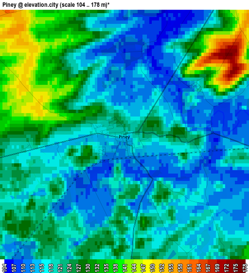
Below is the Elevation map of Piney, which displays elevation range with different colors. Scale of the first map is from 104 to 178 m (341 to 584 ft) with average elevation of 121.9 meters (=400 ft) [note 1]
These maps also provides idea of topography and contour of this city, they are displayed at different zoom levels. More info about maps, scale and edge coordinates you can find below images.
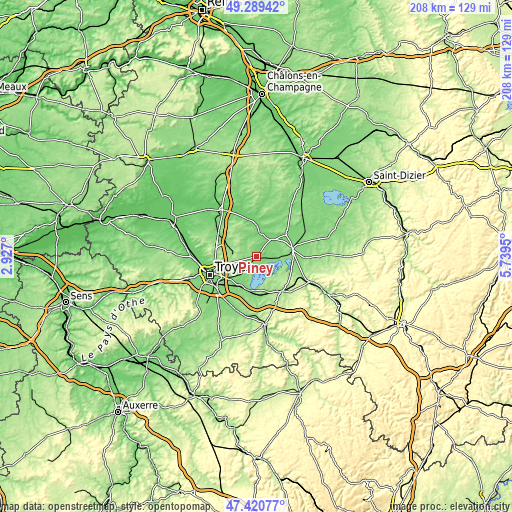
| \ | Map #1 | Topo.Map |
| Scale [m] | 104..178 m | × |
| Scale [ft] | 341..584 ft | × |
| Average | 121.9 m = 400 ft | × |
| Width | 6.49 km = 4 mi | 207.8 km = 129.1 mi |
| Height | 6.49 km = 4 mi | 207.8 km = 129.1 mi |
| ↑Max Latitude | 48.392849° | 49.28942° |
| Latitude at center | 48.36366° | 48.36366° |
| ↓Min Latitude | 48.334454° | 47.42077° |
| ← Min Longitude | 4.289305° | 2.927° |
| Longitude center | 4.33325° | 4.33325° |
| →Max Longitude | 4.377195° | 5.7395° |
Nearby cities:
Cities around Piney sort by population:
• Troyes elevation 105 m
19.6 km,  249°
249°
• Saint-Julien-les-Villas 110 m
20.1 km,  239°
239°
• Pont-Sainte-Marie 104 m
18.3 km, 254°
• Brienne-le-Château 127 m
14.6 km,  77°
77°
• Vendeuvre-sur-Barse 157 m
17.2 km,  144°
144°
• Saint-Parres-aux-Tertres 115 m
17.5 km, 245°
• Bréviandes 115 m
21.2 km, 236°
• Verrières 116 m
19.9 km,  223°
223°
• Sainte-Maure 111 m
20.3 km,  264°
264°
• Creney-près-Troyes 122 m
15.2 km, 257°
• Lusigny-sur-Barse 124 m
13 km,  201°
201°
• Buchères 112 m
21.7 km,  228°
228°
Multilingual:
 En español:
Piney elevación 119 m.
 En France:
Piney élévation 119 m.


Sources and notes:
- [note 1] Map square and city borders are not equal. Map elevation data is calculated only from area inside that square.
- [src 1] Elevation data from geonames database provided with same terms of usage.
- [src 2] The elevation map of Piney is generated using elevation data from NASA's 3 arcsec (90m) resolution SRTM data.
- [src 3] Base (background) map © OpenStreetMap contributors tiles are generated by Geofabrik and OpenTopoMap.
Copyright & License:
This Piney Elevation Map is licensed under CC BY-SA. You may reuse any part from this page, if you give a proper credit by linking to this URL:
 More info on terms of use page.