Saint-Julien-les-Villas elevation
Saint-Julien-les-Villas (Grand Est, Département de l'Aube), France elevation is 110 meters and Saint-Julien-les-Villas elevation in feet is 361 ft above sea level [src 1]. Saint-Julien-les-Villas is a populated place (feature code) with elevation that is 64 meters (210 ft) smaller than average city elevation in France.
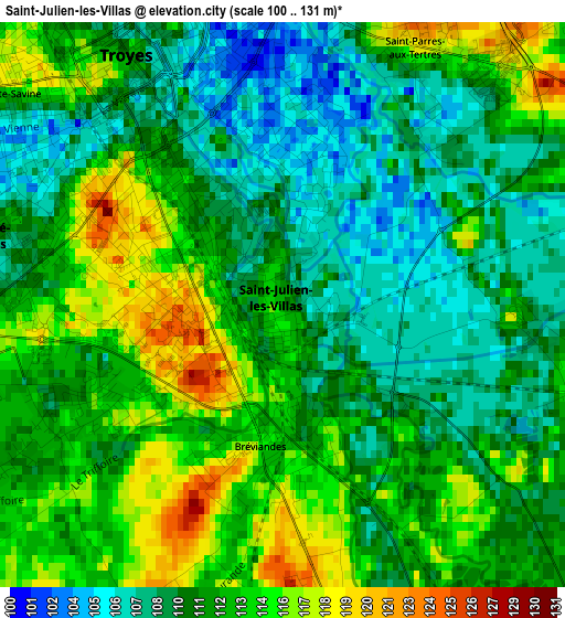
Below is the Elevation map of Saint-Julien-les-Villas, which displays elevation range with different colors. Scale of the first map is from 100 to 131 m (328 to 430 ft) with average elevation of 111.4 meters (=365 ft) [note 1]
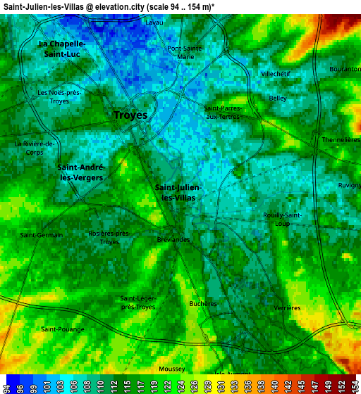
These maps also provides idea of topography and contour of this city, they are displayed at different zoom levels. More info about maps, scale and edge coordinates you can find below images.
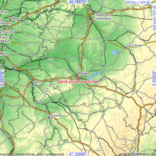
| \ | Map #1 | Map #2 | Topo.Map |
| Scale [m] | 100..131 m | 94..154 m | × |
| Scale [ft] | 328..430 ft | 308..505 ft | × |
| Average | 111.4 m = 365 ft | 114.4 m = 375 ft | × |
| Width | 6.5 km = 4 mi | 13.01 km = 8.1 mi | 208.2 km = 129.4 mi |
| Height | 6.5 km = 4 mi | 13.01 km = 8.1 mi | 208.1 km = 129.3 mi |
| ↑Max Latitude | 48.300512° | 48.329737° | 49.19872° |
| Latitude at center | 48.27127° | 48.27127° | 48.27127° |
| ↓Min Latitude | 48.242011° | 48.212736° | 47.32668° |
| ← Min Longitude | 4.055065° | 4.011119° | 2.69276° |
| Longitude center | 4.09901° | 4.09901° | 4.09901° |
| →Max Longitude | 4.142955° | 4.186901° | 5.50526° |
Nearby cities:
Cities around Saint-Julien-les-Villas sort by population:
• Troyes elevation 105 m
3.4 km,  342°
342°
• Saint-André-les-Vergers 105 m
3.8 km,  294°
294°
• Sainte-Savine 112 m
4.8 km,  305°
305°
• Pont-Sainte-Marie 104 m
5.3 km,  356°
356°
• Les Noës-près-Troyes 106 m
5.3 km, 312°
• La Rivière-de-Corps 113 m
6.2 km, 287°
• Rosières-près-Troyes 114 m
2.1 km,  240°
240°
• Saint-Parres-aux-Tertres 115 m
3.3 km,  24°
24°
• Saint-Germain 118 m
5.2 km,  252°
252°
• Bréviandes 115 m
1.6 km,  189°
189°
• Verrières 116 m
5.6 km,  138°
138°
• Buchères 112 m
4.2 km,  165°
165°
Multilingual:
 En español:
Saint-Julien-les-Villas elevación 110 m.
 En France:
Saint-Julien-les-Villas élévation 110 m.
 Auf Deutsch:
Saint-Julien-les-Villas höhe über dem Meeresspiegel ist 110 m.
 На русском:
Saint-Julien-les-Villas высота над уровнем моря 110 м
Sources and notes:
- [note 1] Map square and city borders are not equal. Map elevation data is calculated only from area inside that square.
- [src 1] Elevation data from geonames database provided with same terms of usage.
- [src 2] The elevation map of Saint-Julien-les-Villas is generated using elevation data from NASA's 3 arcsec (90m) resolution SRTM data.
- [src 3] Base (background) map © OpenStreetMap contributors tiles are generated by Geofabrik and OpenTopoMap.
Copyright & License:
This Saint-Julien-les-Villas Elevation Map is licensed under CC BY-SA. You may reuse any part from this page, if you give a proper credit by linking to this URL:
 More info on terms of use page.