Brienne-le-Château elevation
Brienne-le-Château (Grand Est, Département de l'Aube), France elevation is 127 meters and Brienne-le-Château elevation in feet is 417 ft above sea level [src 1]. Brienne-le-Château is a populated place (feature code) with elevation that is 47 meters (154 ft) smaller than average city elevation in France.
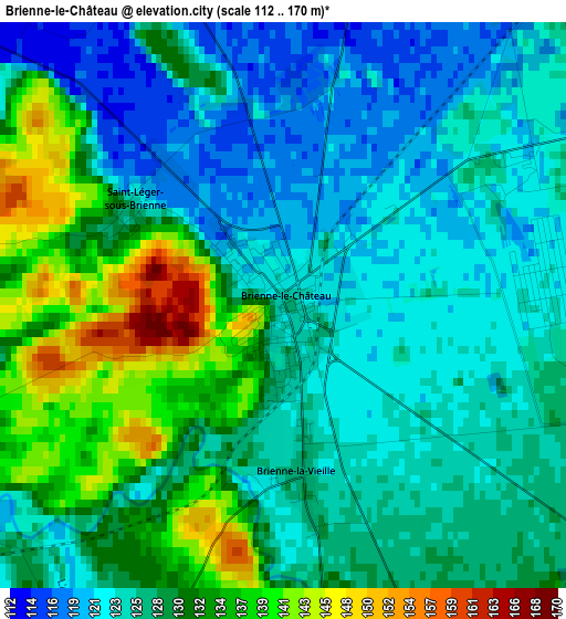
Below is the Elevation map of Brienne-le-Château, which displays elevation range with different colors. Scale of the first map is from 112 to 170 m (367 to 558 ft) with average elevation of 127.9 meters (=420 ft) [note 1]
These maps also provides idea of topography and contour of this city, they are displayed at different zoom levels. More info about maps, scale and edge coordinates you can find below images.
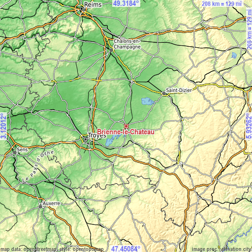
| \ | Map #1 | Topo.Map |
| Scale [m] | 112..170 m | × |
| Scale [ft] | 367..558 ft | × |
| Average | 127.9 m = 420 ft | × |
| Width | 6.49 km = 4 mi | 207.7 km = 129.1 mi |
| Height | 6.49 km = 4 mi | 207.6 km = 129 mi |
| ↑Max Latitude | 48.422362° | 49.3184° |
| Latitude at center | 48.39319° | 48.39319° |
| ↓Min Latitude | 48.364001° | 47.45084° |
| ← Min Longitude | 4.482425° | 3.12012° |
| Longitude center | 4.52637° | 4.52637° |
| →Max Longitude | 4.570315° | 5.93262° |
Nearby cities:
Cities around Brienne-le-Château sort by population:
• Bar-sur-Aube elevation 168 m
22.2 km,  143°
143°
• Pont-Sainte-Marie 104 m
33 km,  255°
255°
• Bar-sur-Seine 151 m
33.1 km,  199°
199°
• Wassy 164 m
33.2 km,  69°
69°
• Arcis-sur-Aube 97 m
32.4 km,  298°
298°
• Vendeuvre-sur-Barse 157 m
17.8 km,  193°
193°
• Saint-Parres-aux-Tertres 115 m
32 km,  250°
250°
• Montier-en-Der 129 m
20.4 km,  62°
62°
• Verrières 116 m
33.1 km,  237°
237°
• Creney-près-Troyes 122 m
29.8 km, 257°
• Lusigny-sur-Barse 124 m
24.5 km,  230°
230°
• Piney 119 m
14.6 km, 257°
Multilingual:
 En español:
Brienne-le-Château elevación 127 m.
 En France:
Brienne-le-Château élévation 127 m.
 Auf Deutsch:
Brienne-le-Château höhe über dem Meeresspiegel ist 127 m.

Sources and notes:
- [note 1] Map square and city borders are not equal. Map elevation data is calculated only from area inside that square.
- [src 1] Elevation data from geonames database provided with same terms of usage.
- [src 2] The elevation map of Brienne-le-Château is generated using elevation data from NASA's 3 arcsec (90m) resolution SRTM data.
- [src 3] Base (background) map © OpenStreetMap contributors tiles are generated by Geofabrik and OpenTopoMap.
Copyright & License:
This Brienne-le-Château Elevation Map is licensed under CC BY-SA. You may reuse any part from this page, if you give a proper credit by linking to this URL:
 More info on terms of use page.