Aulnat elevation
Aulnat (Auvergne-Rhône-Alpes, Département du Puy-de-Dôme), France elevation is 325 meters and Aulnat elevation in feet is 1066 ft above sea level [src 1]. Aulnat is a populated place (feature code) with elevation that is 151 meters (495 ft) bigger than average city elevation in France.
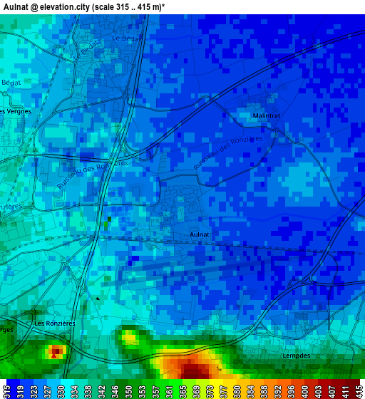
Below is the Elevation map of Aulnat, which displays elevation range with different colors. Scale of the first map is from 315 to 415 m (1033 to 1362 ft) with average elevation of 328.4 meters (=1077 ft) [note 1]
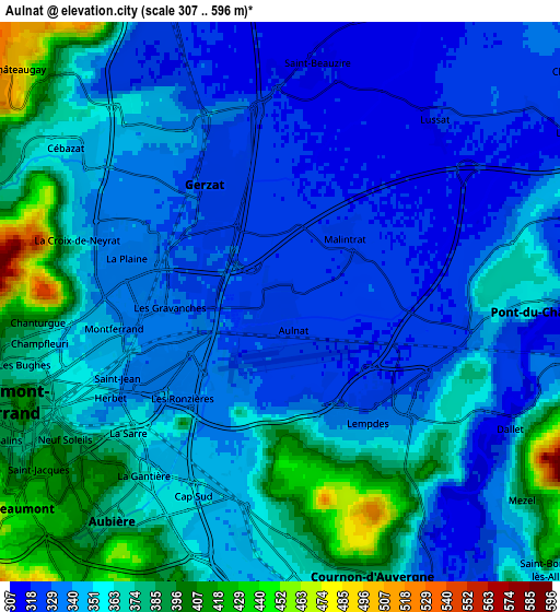
These maps also provides idea of topography and contour of this city, they are displayed at different zoom levels. More info about maps, scale and edge coordinates you can find below images.
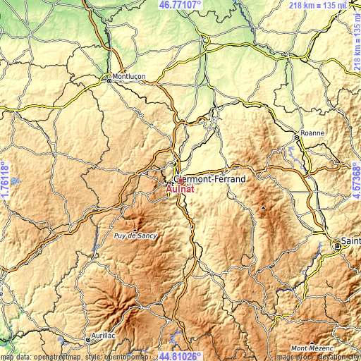
| \ | Map #1 | Map #2 | Topo.Map |
| Scale [m] | 315..415 m | 307..596 m | × |
| Scale [ft] | 1033..1362 ft | 1007..1955 ft | × |
| Average | 328.4 m = 1077 ft | 353 m = 1158 ft | × |
| Width | 6.81 km = 4.2 mi | 13.63 km = 8.5 mi | 218 km = 135.5 mi |
| Height | 6.81 km = 4.2 mi | 13.63 km = 8.5 mi | 218 km = 135.5 mi |
| ↑Max Latitude | 45.829919° | 45.860531° | 46.77107° |
| Latitude at center | 45.79929° | 45.79929° | 45.79929° |
| ↓Min Latitude | 45.768644° | 45.737981° | 44.81026° |
| ← Min Longitude | 3.123485° | 3.079539° | 1.76118° |
| Longitude center | 3.16743° | 3.16743° | 3.16743° |
| →Max Longitude | 3.211375° | 3.255321° | 4.57368° |
Nearby cities:
Cities around Aulnat sort by population:
• Clermont-Ferrand elevation 406 m
6.6 km,  250°
250°
• Cournon-d’Auvergne 359 m
6.8 km,  160°
160°
• Aubière 366 m
7 km,  219°
219°
• Pont-du-Château 317 m
6.3 km,  91°
91°
• Gerzat 320 m
3.4 km,  329°
329°
• Cébazat 348 m
6.3 km,  304°
304°
• Blanzat 372 m
7.7 km, 296°
• Pérignat-lès-Sarliève 353 m
7.3 km,  197°
197°
• Saint-Beauzire 318 m
5.7 km,  9°
9°
• Mezel 382 m
7.6 km,  130°
130°
• Dallet 331 m
6.4 km,  120°
120°
• Malintrat 318 m
2.3 km,  39°
39°
Multilingual:
 En español:
Aulnat elevación 325 m.
 En France:
Aulnat élévation 325 m.


Sources and notes:
- [note 1] Map square and city borders are not equal. Map elevation data is calculated only from area inside that square.
- [src 1] Elevation data from geonames database provided with same terms of usage.
- [src 2] The elevation map of Aulnat is generated using elevation data from NASA's 3 arcsec (90m) resolution SRTM data.
- [src 3] Base (background) map © OpenStreetMap contributors tiles are generated by Geofabrik and OpenTopoMap.
Copyright & License:
This Aulnat Elevation Map is licensed under CC BY-SA. You may reuse any part from this page, if you give a proper credit by linking to this URL:
 More info on terms of use page.