Saint-Beauzire elevation
Saint-Beauzire (Auvergne-Rhône-Alpes, Département du Puy-de-Dôme), France elevation is 318 meters and Saint-Beauzire elevation in feet is 1043 ft above sea level [src 1]. Saint-Beauzire is a populated place (feature code) with elevation that is 144 meters (472 ft) bigger than average city elevation in France.
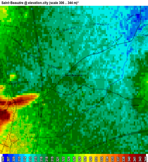
Below is the Elevation map of Saint-Beauzire, which displays elevation range with different colors. Scale of the first map is from 306 to 344 m (1004 to 1129 ft) with average elevation of 317.9 meters (=1043 ft) [note 1]
These maps also provides idea of topography and contour of this city, they are displayed at different zoom levels. More info about maps, scale and edge coordinates you can find below images.
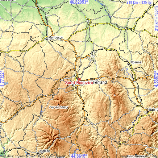
| \ | Map #1 | Topo.Map |
| Scale [m] | 306..344 m | × |
| Scale [ft] | 1004..1129 ft | × |
| Average | 317.9 m = 1043 ft | × |
| Width | 6.81 km = 4.2 mi | 217.8 km = 135.3 mi |
| Height | 6.81 km = 4.2 mi | 217.8 km = 135.3 mi |
| ↑Max Latitude | 45.880241° | 46.82053° |
| Latitude at center | 45.84964° | 45.84964° |
| ↓Min Latitude | 45.819022° | 44.8615° |
| ← Min Longitude | 3.135525° | 1.77322° |
| Longitude center | 3.17947° | 3.17947° |
| →Max Longitude | 3.223415° | 4.58572° |
Nearby cities:
Cities around Saint-Beauzire sort by population:
• Riom elevation 337 m
7.1 km,  313°
313°
• Pont-du-Château 317 m
7.8 km,  136°
136°
• Gerzat 320 m
3.8 km,  225°
225°
• Cébazat 348 m
6.5 km,  251°
251°
• Aulnat 325 m
5.7 km,  189°
189°
• Châteaugay 419 m
7.3 km,  271°
271°
• Ennezat 320 m
6.3 km,  32°
32°
• Les Martres-d'Artière 313 m
7 km,  105°
105°
• Ménétrol 329 m
4.9 km,  299°
299°
• Chappes 312 m
3.8 km,  56°
56°
• Marsat 380 m
8.1 km,  291°
291°
• Malintrat 318 m
3.9 km,  172°
172°
Multilingual:
 En español:
Saint-Beauzire elevación 318 m.
 En France:
Saint-Beauzire élévation 318 m.
 Auf Deutsch:
Saint-Beauzire höhe über dem Meeresspiegel ist 318 m.

Sources and notes:
- [note 1] Map square and city borders are not equal. Map elevation data is calculated only from area inside that square.
- [src 1] Elevation data from geonames database provided with same terms of usage.
- [src 2] The elevation map of Saint-Beauzire is generated using elevation data from NASA's 3 arcsec (90m) resolution SRTM data.
- [src 3] Base (background) map © OpenStreetMap contributors tiles are generated by Geofabrik and OpenTopoMap.
Copyright & License:
This Saint-Beauzire Elevation Map is licensed under CC BY-SA. You may reuse any part from this page, if you give a proper credit by linking to this URL:
 More info on terms of use page.