Auneau elevation
Auneau (Centre, Département d'Eure-et-Loir), France elevation is 145 meters and Auneau elevation in feet is 476 ft above sea level [src 1]. Auneau is a populated place (feature code) with elevation that is 29 meters (95 ft) smaller than average city elevation in France.
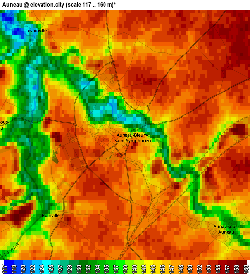
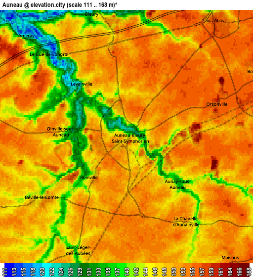
Below is the Elevation map of Auneau, which displays elevation range with different colors. Scale of the first map is from 117 to 160 m (384 to 525 ft) with average elevation of 146.5 meters (=481 ft) [note 1]
These maps also provides idea of topography and contour of this city, they are displayed at different zoom levels. More info about maps, scale and edge coordinates you can find below images.
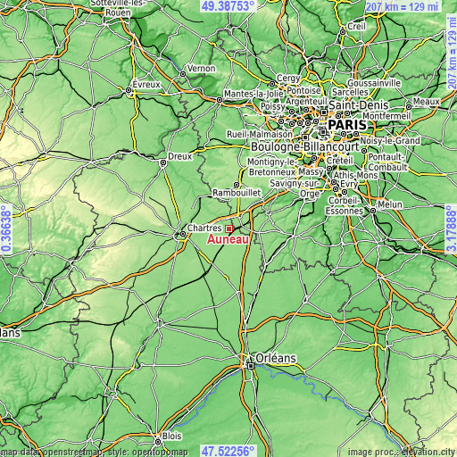
| \ | Map #1 | Map #2 | Topo.Map |
| Scale [m] | 117..160 m | 111..168 m | × |
| Scale [ft] | 384..525 ft | 364..551 ft | × |
| Average | 146.5 m = 481 ft | 148.7 m = 488 ft | × |
| Width | 6.48 km = 4 mi | 12.96 km = 8.1 mi | 207.4 km = 128.9 mi |
| Height | 6.48 km = 4 mi | 12.96 km = 8.1 mi | 207.4 km = 128.9 mi |
| ↑Max Latitude | 48.492742° | 48.521856° | 49.38753° |
| Latitude at center | 48.46361° | 48.46361° | 48.46361° |
| ↓Min Latitude | 48.434462° | 48.405297° | 47.52256° |
| ← Min Longitude | 1.728685° | 1.684739° | 0.36638° |
| Longitude center | 1.77263° | 1.77263° | 1.77263° |
| →Max Longitude | 1.816575° | 1.860521° | 3.17888° |
Nearby cities:
Cities around Auneau sort by population:
• Saint-Arnoult-en-Yvelines elevation 118 m
17.1 km,  45°
45°
• Gallardon 118 m
9.1 km,  319°
319°
• Ablis 156 m
7.6 km,  38°
38°
• Sours 151 m
14.1 km,  245°
245°
• Sonchamp 139 m
14.7 km,  31°
31°
• Corbreuse 151 m
14.3 km,  73°
73°
• Béville-le-Comte 142 m
5.4 km,  234°
234°
• Aunay-sous-Auneau 135 m
3.8 km,  131°
131°
• Nogent-le-Phaye 141 m
14.5 km,  261°
261°
• Armenonville-les-Gâtineaux 118 m
12.8 km,  313°
313°
• Droue-sur-Drouette 127 m
16.1 km,  340°
340°
• Saint-Piat 107 m
16.7 km,  303°
303°
Multilingual:
 En español:
Auneau elevación 145 m.
 En France:
Auneau élévation 145 m.


Sources and notes:
- [note 1] Map square and city borders are not equal. Map elevation data is calculated only from area inside that square.
- [src 1] Elevation data from geonames database provided with same terms of usage.
- [src 2] The elevation map of Auneau is generated using elevation data from NASA's 3 arcsec (90m) resolution SRTM data.
- [src 3] Base (background) map © OpenStreetMap contributors tiles are generated by Geofabrik and OpenTopoMap.
Copyright & License:
This Auneau Elevation Map is licensed under CC BY-SA. You may reuse any part from this page, if you give a proper credit by linking to this URL:
 More info on terms of use page.