Gallardon elevation
Gallardon (Centre, Département d'Eure-et-Loir), France elevation is 118 meters and Gallardon elevation in feet is 387 ft above sea level [src 1]. Gallardon is a populated place (feature code) with elevation that is 56 meters (184 ft) smaller than average city elevation in France.
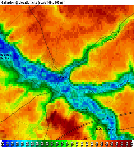
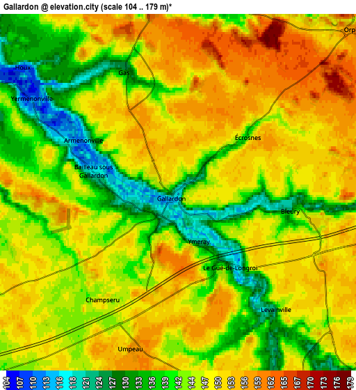
Below is the Elevation map of Gallardon, which displays elevation range with different colors. Scale of the first map is from 109 to 165 m (358 to 541 ft) with average elevation of 142.4 meters (=467 ft) [note 1]
These maps also provides idea of topography and contour of this city, they are displayed at different zoom levels. More info about maps, scale and edge coordinates you can find below images.
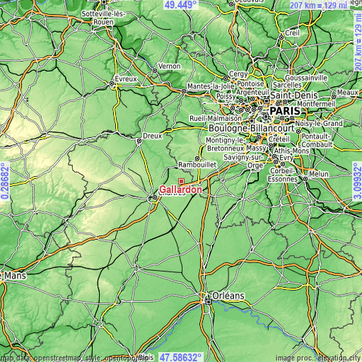
| \ | Map #1 | Map #2 | Topo.Map |
| Scale [m] | 109..165 m | 104..179 m | × |
| Scale [ft] | 358..541 ft | 341..587 ft | × |
| Average | 142.4 m = 467 ft | 145.9 m = 479 ft | × |
| Width | 6.47 km = 4 mi | 12.94 km = 8 mi | 207.1 km = 128.7 mi |
| Height | 6.47 km = 4 mi | 12.94 km = 8 mi | 207.1 km = 128.7 mi |
| ↑Max Latitude | 48.555316° | 48.584395° | 49.449° |
| Latitude at center | 48.52622° | 48.52622° | 48.52622° |
| ↓Min Latitude | 48.497108° | 48.467979° | 47.58632° |
| ← Min Longitude | 1.649125° | 1.605179° | 0.28682° |
| Longitude center | 1.69307° | 1.69307° | 1.69307° |
| →Max Longitude | 1.737015° | 1.780961° | 3.09932° |
Nearby cities:
Cities around Gallardon sort by population:
• Épernon elevation 118 m
9.5 km,  350°
350°
• Maintenon 103 m
10.8 km,  308°
308°
• Auneau 145 m
9.1 km,  139°
139°
• Ablis 156 m
10.6 km,  95°
95°
• Pierres 99 m
12 km, 307°
• Hanches 112 m
8.9 km,  339°
339°
• Jouy 116 m
11.1 km,  260°
260°
• Béville-le-Comte 142 m
10.2 km,  171°
171°
• Armenonville-les-Gâtineaux 118 m
3.9 km,  300°
300°
• Saint-Martin-de-Nigelles 111 m
11.4 km,  327°
327°
• Droue-sur-Drouette 127 m
8.3 km,  4°
4°
• Saint-Piat 107 m
8.4 km,  285°
285°
Multilingual:
 En español:
Gallardon elevación 118 m.
 En France:
Gallardon élévation 118 m.
 Auf Deutsch:
Gallardon höhe über dem Meeresspiegel ist 118 m.

Sources and notes:
- [note 1] Map square and city borders are not equal. Map elevation data is calculated only from area inside that square.
- [src 1] Elevation data from geonames database provided with same terms of usage.
- [src 2] The elevation map of Gallardon is generated using elevation data from NASA's 3 arcsec (90m) resolution SRTM data.
- [src 3] Base (background) map © OpenStreetMap contributors tiles are generated by Geofabrik and OpenTopoMap.
Copyright & License:
This Gallardon Elevation Map is licensed under CC BY-SA. You may reuse any part from this page, if you give a proper credit by linking to this URL:
 More info on terms of use page.