Ballon elevation
Ballon (Pays de la Loire, Sarthe), France elevation is 109 meters and Ballon elevation in feet is 358 ft above sea level [src 1]. Ballon is a populated place (feature code) with elevation that is 65 meters (213 ft) smaller than average city elevation in France.
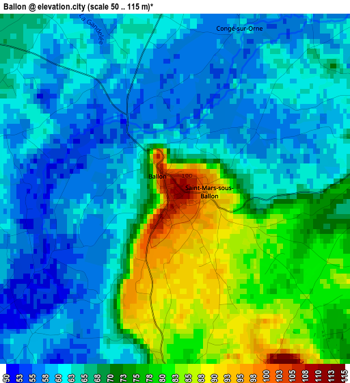
Below is the Elevation map of Ballon, which displays elevation range with different colors. Scale of the first map is from 50 to 115 m (164 to 377 ft) with average elevation of 67.3 meters (=221 ft) [note 1]
These maps also provides idea of topography and contour of this city, they are displayed at different zoom levels. More info about maps, scale and edge coordinates you can find below images.
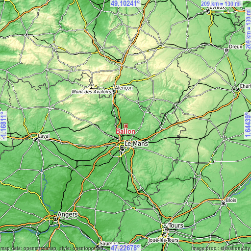
| \ | Map #1 | Topo.Map |
| Scale [m] | 50..115 m | × |
| Scale [ft] | 164..377 ft | × |
| Average | 67.3 m = 221 ft | × |
| Width | 6.52 km = 4.1 mi | 208.6 km = 129.6 mi |
| Height | 6.52 km = 4.1 mi | 208.5 km = 129.6 mi |
| ↑Max Latitude | 48.202468° | 49.10241° |
| Latitude at center | 48.17317° | 48.17317° |
| ↓Min Latitude | 48.143855° | 47.22678° |
| ← Min Longitude | 0.194195° | -1.16811° |
| Longitude center | 0.23814° | 0.23814° |
| →Max Longitude | 0.282085° | 1.64439° |
Nearby cities:
Cities around Ballon sort by population:
• Bonnétable elevation 106 m
13.9 km,  87°
87°
• La Bazoge 98 m
10.5 km,  215°
215°
• La Milesse 58 m
14.5 km,  212°
212°
• Neuville-sur-Sarthe 51 m
11.3 km,  197°
197°
• Saint-Saturnin 68 m
14.3 km, 206°
• Marolles-les-Braults 85 m
10.6 km,  33°
33°
• Beaumont-sur-Sarthe 77 m
9.9 km,  307°
307°
• Sainte-Jamme-sur-Sarthe 56 m
6.2 km,  237°
237°
• Aigné 69 m
15 km, 216°
• Beaufay 94 m
9.7 km,  107°
107°
• Montbizot 64 m
4.8 km, 237°
• Souligné-sous-Ballon 71 m
4 km,  182°
182°
Multilingual:
 En español:
Ballon elevación 109 m.
 En France:
Ballon élévation 109 m.


Sources and notes:
- [note 1] Map square and city borders are not equal. Map elevation data is calculated only from area inside that square.
- [src 1] Elevation data from geonames database provided with same terms of usage.
- [src 2] The elevation map of Ballon is generated using elevation data from NASA's 3 arcsec (90m) resolution SRTM data.
- [src 3] Base (background) map © OpenStreetMap contributors tiles are generated by Geofabrik and OpenTopoMap.
Copyright & License:
This Ballon Elevation Map is licensed under CC BY-SA. You may reuse any part from this page, if you give a proper credit by linking to this URL:
 More info on terms of use page.