Beaufay elevation
Beaufay (Pays de la Loire, Sarthe), France elevation is 94 meters and Beaufay elevation in feet is 308 ft above sea level [src 1]. Beaufay is a populated place (feature code) with elevation that is 80 meters (262 ft) smaller than average city elevation in France.
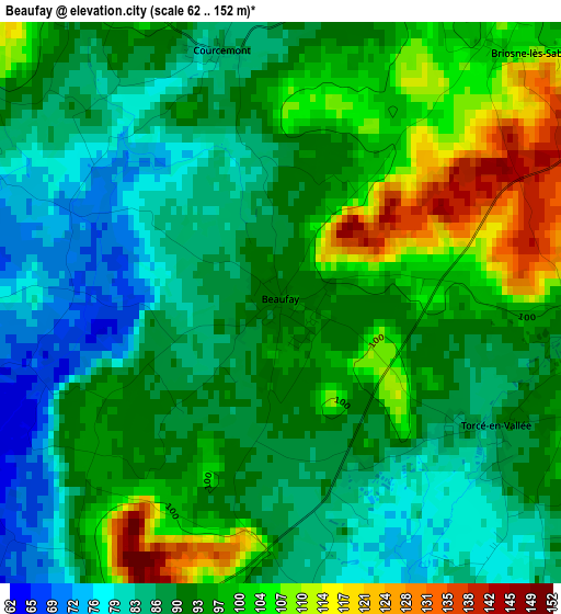
Below is the Elevation map of Beaufay, which displays elevation range with different colors. Scale of the first map is from 62 to 152 m (203 to 499 ft) with average elevation of 92.8 meters (=304 ft) [note 1]
These maps also provides idea of topography and contour of this city, they are displayed at different zoom levels. More info about maps, scale and edge coordinates you can find below images.
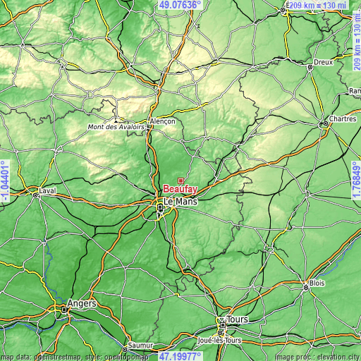
| \ | Map #1 | Topo.Map |
| Scale [m] | 62..152 m | × |
| Scale [ft] | 203..499 ft | × |
| Average | 92.8 m = 304 ft | × |
| Width | 6.52 km = 4.1 mi | 208.7 km = 129.7 mi |
| Height | 6.52 km = 4.1 mi | 208.6 km = 129.6 mi |
| ↑Max Latitude | 48.175953° | 49.07636° |
| Latitude at center | 48.14664° | 48.14664° |
| ↓Min Latitude | 48.11731° | 47.19977° |
| ← Min Longitude | 0.318295° | -1.04401° |
| Longitude center | 0.36224° | 0.36224° |
| →Max Longitude | 0.406185° | 1.76849° |
Nearby cities:
Cities around Beaufay sort by population:
• Bonnétable elevation 106 m
5.9 km,  52°
52°
• Champagné 66 m
14.1 km,  189°
189°
• Montfort-le-Gesnois 64 m
11.5 km,  159°
159°
• Connerré 78 m
13.9 km,  135°
135°
• Saint-Mars-la-Brière 59 m
12.9 km,  176°
176°
• Marolles-les-Braults 85 m
12.3 km,  343°
343°
• Lombron 89 m
8.6 km,  150°
150°
• Sainte-Jamme-sur-Sarthe 56 m
14.5 km,  268°
268°
• Tuffé 90 m
12 km,  108°
108°
• Ballon 109 m
9.7 km,  287°
287°
• Montbizot 64 m
13.2 km, 271°
• Souligné-sous-Ballon 71 m
9.4 km,  263°
263°
Multilingual:
 En español:
Beaufay elevación 94 m.
 En France:
Beaufay élévation 94 m.


Sources and notes:
- [note 1] Map square and city borders are not equal. Map elevation data is calculated only from area inside that square.
- [src 1] Elevation data from geonames database provided with same terms of usage.
- [src 2] The elevation map of Beaufay is generated using elevation data from NASA's 3 arcsec (90m) resolution SRTM data.
- [src 3] Base (background) map © OpenStreetMap contributors tiles are generated by Geofabrik and OpenTopoMap.
Copyright & License:
This Beaufay Elevation Map is licensed under CC BY-SA. You may reuse any part from this page, if you give a proper credit by linking to this URL:
 More info on terms of use page.