Connerré elevation
Connerré (Pays de la Loire, Sarthe), France elevation is 78 meters and Connerré elevation in feet is 256 ft above sea level [src 1]. Connerré is a populated place (feature code) with elevation that is 96 meters (315 ft) smaller than average city elevation in France.
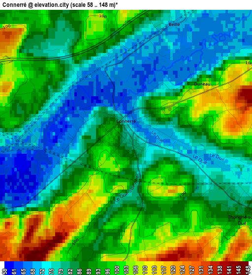
Below is the Elevation map of Connerré, which displays elevation range with different colors. Scale of the first map is from 58 to 148 m (190 to 486 ft) with average elevation of 89.1 meters (=292 ft) [note 1]
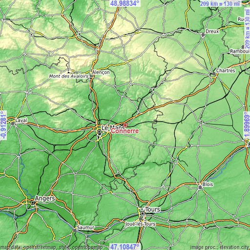
These maps also provides idea of topography and contour of this city, they are displayed at different zoom levels. More info about maps, scale and edge coordinates you can find below images.
| \ | Map #1 | Topo.Map |
| Scale [m] | 58..148 m | × |
| Scale [ft] | 190..486 ft | × |
| Average | 89.1 m = 292 ft | × |
| Width | 6.53 km = 4.1 mi | 209 km = 129.9 mi |
| Height | 6.53 km = 4.1 mi | 209 km = 129.9 mi |
| ↑Max Latitude | 48.086344° | 48.98834° |
| Latitude at center | 48.05698° | 48.05698° |
| ↓Min Latitude | 48.027599° | 47.10847° |
| ← Min Longitude | 0.449495° | -0.91281° |
| Longitude center | 0.49344° | 0.49344° |
| →Max Longitude | 0.537385° | 1.89969° |
Nearby cities:
Cities around Connerré sort by population:
• Bonnétable elevation 106 m
14.5 km,  339°
339°
• Champagné 66 m
12.7 km,  252°
252°
• Montfort-le-Gesnois 64 m
5.8 km,  262°
262°
• Saint-Mars-la-Brière 59 m
9.4 km, 251°
• Bouloire 129 m
10.2 km,  155°
155°
• Lombron 89 m
6.1 km,  293°
293°
• Tuffé 90 m
6.5 km,  14°
14°
• Thorigné-sur-Dué 87 m
3.7 km,  122°
122°
• Beaufay 94 m
13.9 km,  315°
315°
• Dollon 116 m
7.2 km,  106°
106°
• Le Breil-sur-Mérize 110 m
5.6 km,  191°
191°
• Le Luart 95 m
7 km,  77°
77°
Multilingual:
 En español:
Connerré elevación 78 m.
 En France:
Connerré élévation 78 m.


Sources and notes:
- [note 1] Map square and city borders are not equal. Map elevation data is calculated only from area inside that square.
- [src 1] Elevation data from geonames database provided with same terms of usage.
- [src 2] The elevation map of Connerré is generated using elevation data from NASA's 3 arcsec (90m) resolution SRTM data.
- [src 3] Base (background) map © OpenStreetMap contributors tiles are generated by Geofabrik and OpenTopoMap.
Copyright & License:
This Connerré Elevation Map is licensed under CC BY-SA. You may reuse any part from this page, if you give a proper credit by linking to this URL:
 More info on terms of use page.