Beaumont-sur-Sarthe elevation
Beaumont-sur-Sarthe (Pays de la Loire, Sarthe), France elevation is 77 meters and Beaumont-sur-Sarthe elevation in feet is 253 ft above sea level [src 1]. Beaumont-sur-Sarthe is a populated place (feature code) with elevation that is 97 meters (318 ft) smaller than average city elevation in France.
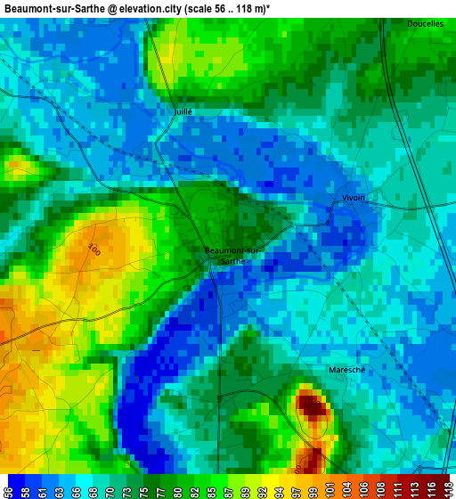
Below is the Elevation map of Beaumont-sur-Sarthe, which displays elevation range with different colors. Scale of the first map is from 56 to 118 m (184 to 387 ft) with average elevation of 73.8 meters (=242 ft) [note 1]
These maps also provides idea of topography and contour of this city, they are displayed at different zoom levels. More info about maps, scale and edge coordinates you can find below images.
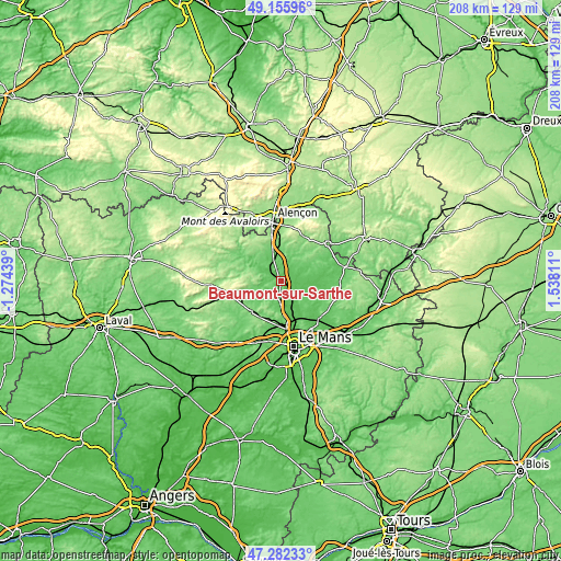
| \ | Map #1 | Topo.Map |
| Scale [m] | 56..118 m | × |
| Scale [ft] | 184..387 ft | × |
| Average | 73.8 m = 242 ft | × |
| Width | 6.51 km = 4 mi | 208.3 km = 129.4 mi |
| Height | 6.51 km = 4 mi | 208.3 km = 129.4 mi |
| ↑Max Latitude | 48.256987° | 49.15596° |
| Latitude at center | 48.22772° | 48.22772° |
| ↓Min Latitude | 48.198437° | 47.28233° |
| ← Min Longitude | 0.087915° | -1.27439° |
| Longitude center | 0.13186° | 0.13186° |
| →Max Longitude | 0.175805° | 1.53811° |
Nearby cities:
Cities around Beaumont-sur-Sarthe sort by population:
• La Bazoge elevation 98 m
14.7 km,  173°
173°
• Fresnay-sur-Sarthe 97 m
10.1 km,  306°
306°
• La Milesse 58 m
18.3 km,  179°
179°
• Neuville-sur-Sarthe 51 m
17.4 km, 165°
• Marolles-les-Braults 85 m
13.9 km,  78°
78°
• Conlie 117 m
16 km,  223°
223°
• Sainte-Jamme-sur-Sarthe 56 m
9.8 km,  164°
164°
• Ballon 109 m
9.9 km,  127°
127°
• Aigné 69 m
18.1 km, 182°
• Montbizot 64 m
9.5 km, 155°
• Champfleur 147 m
17.7 km,  359°
359°
• Souligné-sous-Ballon 71 m
12.6 km,  142°
142°
Multilingual:
 En español:
Beaumont-sur-Sarthe elevación 77 m.
 En France:
Beaumont-sur-Sarthe élévation 77 m.
 Auf Deutsch:
Beaumont-sur-Sarthe höhe über dem Meeresspiegel ist 77 m.
 На русском:
Beaumont-sur-Sarthe высота над уровнем моря 77 м
Sources and notes:
- [note 1] Map square and city borders are not equal. Map elevation data is calculated only from area inside that square.
- [src 1] Elevation data from geonames database provided with same terms of usage.
- [src 2] The elevation map of Beaumont-sur-Sarthe is generated using elevation data from NASA's 3 arcsec (90m) resolution SRTM data.
- [src 3] Base (background) map © OpenStreetMap contributors tiles are generated by Geofabrik and OpenTopoMap.
Copyright & License:
This Beaumont-sur-Sarthe Elevation Map is licensed under CC BY-SA. You may reuse any part from this page, if you give a proper credit by linking to this URL:
 More info on terms of use page.