Beaune elevation
Beaune (Bourgogne-Franche-Comté, Département de la Côte-d'Or), France elevation is 214 meters and Beaune elevation in feet is 702 ft above sea level [src 1]. Beaune is a seat of a third-order administrative division (feature code) with elevation that is 40 meters (131 ft) bigger than average city elevation in France.
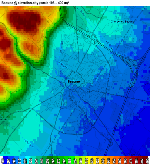
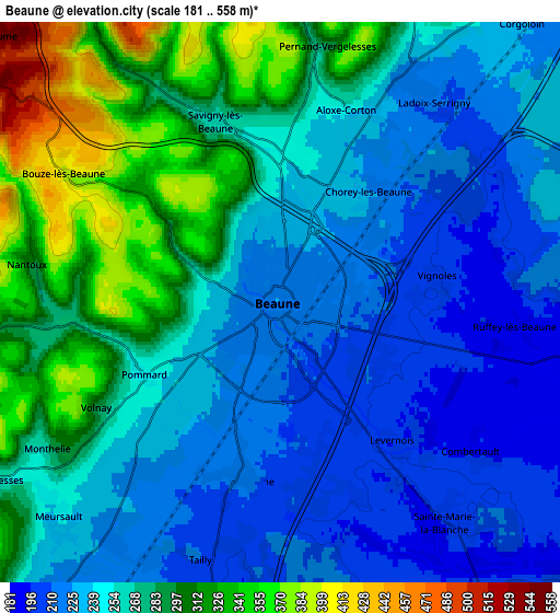
Below is the Elevation map of Beaune, which displays elevation range with different colors. Scale of the first map is from 193 to 400 m (633 to 1312 ft) with average elevation of 239.5 meters (=786 ft) [note 1]
These maps also provides idea of topography and contour of this city, they are displayed at different zoom levels. More info about maps, scale and edge coordinates you can find below images.
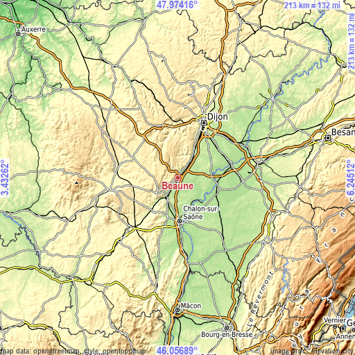
| \ | Map #1 | Map #2 | Topo.Map |
| Scale [m] | 193..400 m | 181..558 m | × |
| Scale [ft] | 633..1312 ft | 594..1831 ft | × |
| Average | 239.5 m = 786 ft | 260.5 m = 855 ft | × |
| Width | 6.66 km = 4.1 mi | 13.32 km = 8.3 mi | 213.2 km = 132.5 mi |
| Height | 6.66 km = 4.1 mi | 13.32 km = 8.3 mi | 213.2 km = 132.5 mi |
| ↑Max Latitude | 47.054079° | 47.084011° | 47.97416° |
| Latitude at center | 47.02413° | 47.02413° | 47.02413° |
| ↓Min Latitude | 46.994165° | 46.964182° | 46.05689° |
| ← Min Longitude | 4.794925° | 4.750979° | 3.43262° |
| Longitude center | 4.83887° | 4.83887° | 4.83887° |
| →Max Longitude | 4.882815° | 4.926761° | 6.24512° |
Nearby cities:
Cities around Beaune sort by population:
• Chagny elevation 210 m
14.3 km,  207°
207°
• Nuits-Saint-Georges 242 m
15.1 km,  33°
33°
• Gergy 188 m
18.4 km,  153°
153°
• Ladoix-Serrigny 217 m
5.8 km,  35°
35°
• Meursault 249 m
7.3 km,  225°
225°
• Demigny 198 m
10.4 km,  182°
182°
• Rully 222 m
18.1 km,  203°
203°
• Nolay 328 m
17.5 km,  242°
242°
• Savigny-lès-Beaune 265 m
4.7 km,  340°
340°
• Bligny-lès-Beaune 220 m
4.3 km,  192°
192°
• Verdun-sur-le-Doubs 176 m
19.8 km,  135°
135°
• Corpeau 228 m
12.4 km, 211°
Multilingual:
 En español:
Beaune elevación 214 m.
 En France:
Beaune élévation 214 m.


Sources and notes:
- [note 1] Map square and city borders are not equal. Map elevation data is calculated only from area inside that square.
- [src 1] Elevation data from geonames database provided with same terms of usage.
- [src 2] The elevation map of Beaune is generated using elevation data from NASA's 3 arcsec (90m) resolution SRTM data.
- [src 3] Base (background) map © OpenStreetMap contributors tiles are generated by Geofabrik and OpenTopoMap.
Copyright & License:
This Beaune Elevation Map is licensed under CC BY-SA. You may reuse any part from this page, if you give a proper credit by linking to this URL:
 More info on terms of use page.