Nuits-Saint-Georges elevation
Nuits-Saint-Georges (Bourgogne-Franche-Comté, Département de la Côte-d'Or), France elevation is 242 meters and Nuits-Saint-Georges elevation in feet is 794 ft above sea level [src 1]. Nuits-Saint-Georges is a populated place (feature code) with elevation that is 68 meters (223 ft) bigger than average city elevation in France.
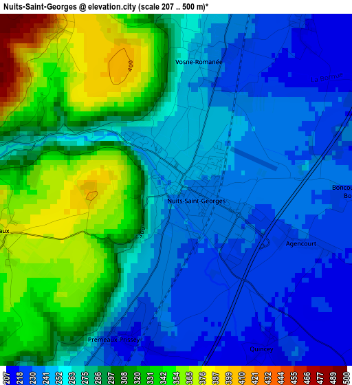
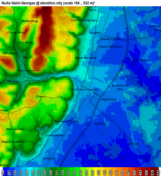
Below is the Elevation map of Nuits-Saint-Georges, which displays elevation range with different colors. Scale of the first map is from 207 to 500 m (679 to 1640 ft) with average elevation of 278.3 meters (=913 ft) [note 1]
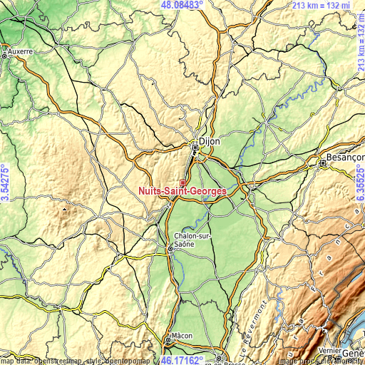
These maps also provides idea of topography and contour of this city, they are displayed at different zoom levels. More info about maps, scale and edge coordinates you can find below images.
| \ | Map #1 | Map #2 | Topo.Map |
| Scale [m] | 207..500 m | 194..532 m | × |
| Scale [ft] | 679..1640 ft | 636..1745 ft | × |
| Average | 278.3 m = 913 ft | 282.2 m = 926 ft | × |
| Width | 6.65 km = 4.1 mi | 13.3 km = 8.3 mi | 212.7 km = 132.2 mi |
| Height | 6.65 km = 4.1 mi | 13.3 km = 8.3 mi | 212.7 km = 132.2 mi |
| ↑Max Latitude | 47.166715° | 47.196584° | 48.08483° |
| Latitude at center | 47.13683° | 47.13683° | 47.13683° |
| ↓Min Latitude | 47.106928° | 47.077009° | 46.17162° |
| ← Min Longitude | 4.905055° | 4.861109° | 3.54275° |
| Longitude center | 4.949° | 4.949° | 4.949° |
| →Max Longitude | 4.992945° | 5.036891° | 6.35525° |
Nearby cities:
Cities around Nuits-Saint-Georges sort by population:
• Beaune elevation 214 m
15.1 km,  213°
213°
• Chenôve 266 m
17.9 km,  13°
13°
• Marsannay-la-Côte 276 m
15.2 km, 11°
• Gevrey-Chambertin 281 m
10 km, 8°
• Ladoix-Serrigny 217 m
9.2 km, 212°
• Perrigny-lès-Dijon 254 m
15.1 km,  16°
16°
• Savigny-lès-Beaune 265 m
12.8 km,  230°
230°
• Ouges 218 m
16.8 km,  34°
34°
• Fénay 228 m
13.6 km,  38°
38°
• Longecourt-en-Plaine 197 m
16.6 km,  65°
65°
• Couchey 278 m
13.9 km, 10°
• Aiserey 194 m
16.6 km,  76°
76°
Multilingual:
 En español:
Nuits-Saint-Georges elevación 242 m.
 En France:
Nuits-Saint-Georges élévation 242 m.
 Auf Deutsch:
Nuits-Saint-Georges höhe über dem Meeresspiegel ist 242 m.

Sources and notes:
- [note 1] Map square and city borders are not equal. Map elevation data is calculated only from area inside that square.
- [src 1] Elevation data from geonames database provided with same terms of usage.
- [src 2] The elevation map of Nuits-Saint-Georges is generated using elevation data from NASA's 3 arcsec (90m) resolution SRTM data.
- [src 3] Base (background) map © OpenStreetMap contributors tiles are generated by Geofabrik and OpenTopoMap.
Copyright & License:
This Nuits-Saint-Georges Elevation Map is licensed under CC BY-SA. You may reuse any part from this page, if you give a proper credit by linking to this URL:
 More info on terms of use page.