Brou elevation
Brou (Centre, Département d'Eure-et-Loir), France elevation is 157 meters and Brou elevation in feet is 515 ft above sea level [src 1]. Brou is a populated place (feature code) with elevation that is 17 meters (56 ft) smaller than average city elevation in France.
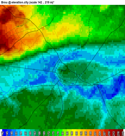
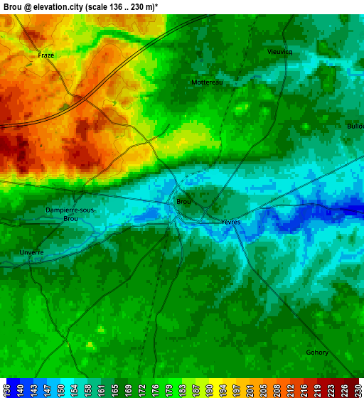
Below is the Elevation map of Brou, which displays elevation range with different colors. Scale of the first map is from 142 to 219 m (466 to 719 ft) with average elevation of 168.8 meters (=554 ft) [note 1]
These maps also provides idea of topography and contour of this city, they are displayed at different zoom levels. More info about maps, scale and edge coordinates you can find below images.
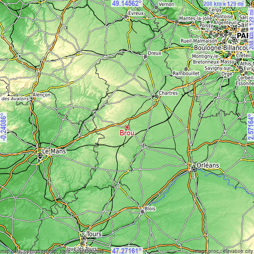
| \ | Map #1 | Map #2 | Topo.Map |
| Scale [m] | 142..219 m | 136..230 m | × |
| Scale [ft] | 466..719 ft | 446..755 ft | × |
| Average | 168.8 m = 554 ft | 172.5 m = 566 ft | × |
| Width | 6.51 km = 4 mi | 13.02 km = 8.1 mi | 208.4 km = 129.5 mi |
| Height | 6.51 km = 4 mi | 13.02 km = 8.1 mi | 208.4 km = 129.5 mi |
| ↑Max Latitude | 48.246463° | 48.275719° | 49.14562° |
| Latitude at center | 48.21719° | 48.21719° | 48.21719° |
| ↓Min Latitude | 48.1879° | 48.158594° | 47.27161° |
| ← Min Longitude | 1.121445° | 1.077499° | -0.24086° |
| Longitude center | 1.16539° | 1.16539° | 1.16539° |
| →Max Longitude | 1.209335° | 1.253281° | 2.57164° |
Nearby cities:
Cities around Brou sort by population:
• Châteaudun elevation 129 m
20.7 km,  141°
141°
• Bonneval 125 m
16.7 km,  103°
103°
• Arrou 161 m
13.6 km,  191°
191°
• Yèvres 160 m
1.8 km,  113°
113°
• Saint-Denis-les-Ponts 106 m
19.4 km,  149°
149°
• Bailleau-le-Pin 173 m
20.6 km,  36°
36°
• La Bazoche-Gouet 191 m
16.1 km,  237°
237°
• Authon-du-Perche 240 m
20.4 km,  263°
263°
• Marboué 114 m
16.9 km,  132°
132°
• Thiron Gardais 245 m
17.4 km,  309°
309°
• Droué 151 m
20.8 km,  198°
198°
• Unverre 164 m
5.8 km,  248°
248°
Multilingual:
 En español:
Brou elevación 157 m.
 En France:
Brou élévation 157 m.


Sources and notes:
- [note 1] Map square and city borders are not equal. Map elevation data is calculated only from area inside that square.
- [src 1] Elevation data from geonames database provided with same terms of usage.
- [src 2] The elevation map of Brou is generated using elevation data from NASA's 3 arcsec (90m) resolution SRTM data.
- [src 3] Base (background) map © OpenStreetMap contributors tiles are generated by Geofabrik and OpenTopoMap.
Copyright & License:
This Brou Elevation Map is licensed under CC BY-SA. You may reuse any part from this page, if you give a proper credit by linking to this URL:
 More info on terms of use page.