Châteaudun elevation
Châteaudun (Centre, Département d'Eure-et-Loir), France elevation is 129 meters and Châteaudun elevation in feet is 423 ft above sea level [src 1]. Châteaudun is a seat of a third-order administrative division (feature code) with elevation that is 45 meters (148 ft) smaller than average city elevation in France.
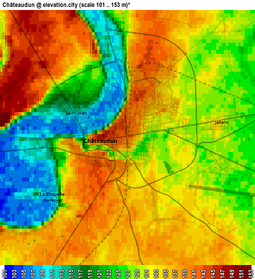
Below is the Elevation map of Châteaudun, which displays elevation range with different colors. Scale of the first map is from 101 to 153 m (331 to 502 ft) with average elevation of 130 meters (=427 ft) [note 1]
These maps also provides idea of topography and contour of this city, they are displayed at different zoom levels. More info about maps, scale and edge coordinates you can find below images.
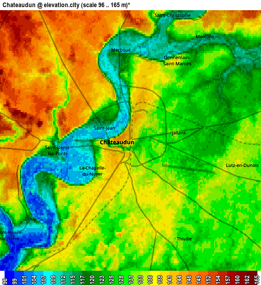
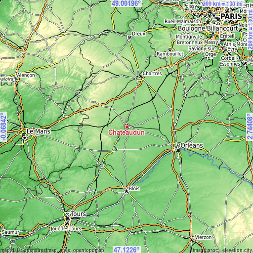
| \ | Map #1 | Map #2 | Topo.Map |
| Scale [m] | 101..153 m | 96..165 m | × |
| Scale [ft] | 331..502 ft | 315..541 ft | × |
| Average | 130 m = 427 ft | 131.1 m = 430 ft | × |
| Width | 6.53 km = 4.1 mi | 13.06 km = 8.1 mi | 209 km = 129.9 mi |
| Height | 6.53 km = 4.1 mi | 13.06 km = 8.1 mi | 209 km = 129.9 mi |
| ↑Max Latitude | 48.100216° | 48.129556° | 49.00196° |
| Latitude at center | 48.07086° | 48.07086° | 48.07086° |
| ↓Min Latitude | 48.041487° | 48.012097° | 47.1226° |
| ← Min Longitude | 1.293885° | 1.249939° | -0.06842° |
| Longitude center | 1.33783° | 1.33783° | 1.33783° |
| →Max Longitude | 1.381775° | 1.425721° | 2.74408° |
Nearby cities:
Cities around Châteaudun sort by population:
• Bonneval elevation 125 m
13 km,  15°
15°
• Brou 157 m
20.7 km,  321°
321°
• Cloyes-sur-le-Loir 98 m
11.1 km,  222°
222°
• Arrou 161 m
15.8 km,  280°
280°
• Yèvres 160 m
19.2 km, 324°
• Ouzouer-le-Marché 132 m
22.7 km,  141°
141°
• Saint-Denis-les-Ponts 106 m
3 km,  261°
261°
• La Chapelle-du-Noyer 138 m
4.8 km,  205°
205°
• Marboué 114 m
4.8 km,  354°
354°
• Droué 151 m
19.8 km, 260°
• Morée 97 m
20.1 km,  202°
202°
• Unverre 164 m
23.1 km,  307°
307°
Multilingual:
 En español:
Châteaudun elevación 129 m.
 En France:
Châteaudun élévation 129 m.
 Auf Deutsch:
Châteaudun höhe über dem Meeresspiegel ist 129 m.

Sources and notes:
- [note 1] Map square and city borders are not equal. Map elevation data is calculated only from area inside that square.
- [src 1] Elevation data from geonames database provided with same terms of usage.
- [src 2] The elevation map of Châteaudun is generated using elevation data from NASA's 3 arcsec (90m) resolution SRTM data.
- [src 3] Base (background) map © OpenStreetMap contributors tiles are generated by Geofabrik and OpenTopoMap.
Copyright & License:
This Châteaudun Elevation Map is licensed under CC BY-SA. You may reuse any part from this page, if you give a proper credit by linking to this URL:
 More info on terms of use page.