Carcassonne elevation
Carcassonne (Occitanie, Département de l'Aude), France elevation is 103 meters and Carcassonne elevation in feet is 338 ft above sea level [src 1]. Carcassonne is a seat of a second-order administrative division (feature code) with elevation that is 71 meters (233 ft) smaller than average city elevation in France.
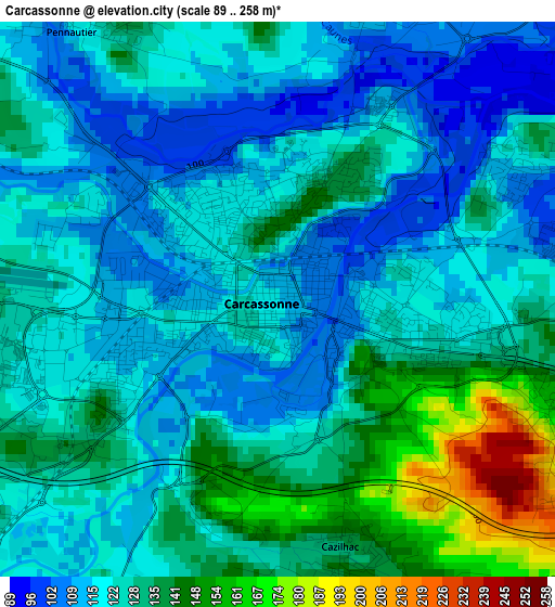
Below is the Elevation map of Carcassonne, which displays elevation range with different colors. Scale of the first map is from 89 to 258 m (292 to 846 ft) with average elevation of 125.3 meters (=411 ft) [note 1]
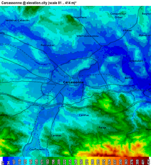
These maps also provides idea of topography and contour of this city, they are displayed at different zoom levels. More info about maps, scale and edge coordinates you can find below images.
| \ | Map #1 | Map #2 | Topo.Map |
| Scale [m] | 89..258 m | 81..414 m | × |
| Scale [ft] | 292..846 ft | 266..1358 ft | × |
| Average | 125.3 m = 411 ft | 145.6 m = 478 ft | × |
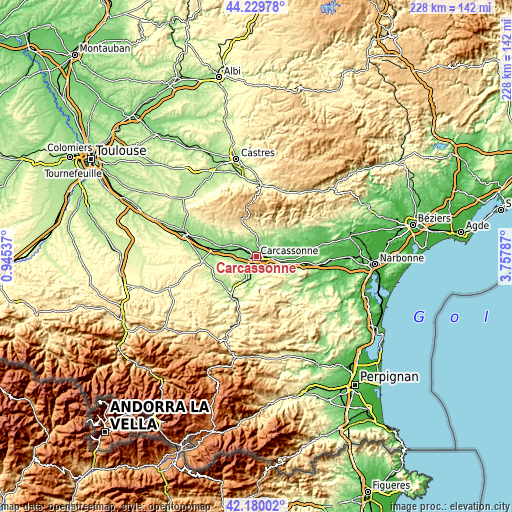
| Width | 7.12 km = 4.4 mi | 14.24 km = 8.8 mi | 227.9 km = 141.6 mi |
| Height | 7.12 km = 4.4 mi | 14.24 km = 8.8 mi | 227.9 km = 141.6 mi |
| ↑Max Latitude | 43.245529° | 43.277532° | 44.22978° |
| Latitude at center | 43.21351° | 43.21351° | 43.21351° |
| ↓Min Latitude | 43.181474° | 43.149421° | 42.18002° |
| ← Min Longitude | 2.307675° | 2.263729° | 0.94537° |
| Longitude center | 2.35162° | 2.35162° | 2.35162° |
| →Max Longitude | 2.395565° | 2.439511° | 3.75787° |
Nearby cities:
Cities around Carcassonne sort by population:
• Trèbes elevation 94 m
7.3 km,  92°
92°
• Villemoustaussou 115 m
4.4 km,  14°
14°
• Pennautier 117 m
4.4 km,  323°
323°
• Conques-sur-Orbiel 125 m
7.9 km,  41°
41°
• Palaja 178 m
5.2 km,  148°
148°
• Cazilhac 140 m
3.6 km,  167°
167°
• Villegailhenc 130 m
6.1 km,  2°
2°
• Pezens 122 m
8.1 km,  304°
304°
• Alzonne 125 m
14.7 km,  287°
287°
• Laure-Minervois 87 m
15.1 km,  64°
64°
• Lavalette 187 m
7.5 km,  244°
244°
• Arzens 198 m
11.6 km,  261°
261°
Multilingual:
 En español:
Carcasona elevación 103 m.
 En France:
Carcassonne élévation 103 m.
 Auf Deutsch:
Carcassonne höhe über dem Meeresspiegel ist 103 m.

Sources and notes:
- [note 1] Map square and city borders are not equal. Map elevation data is calculated only from area inside that square.
- [src 1] Elevation data from geonames database provided with same terms of usage.
- [src 2] The elevation map of Carcassonne is generated using elevation data from NASA's 3 arcsec (90m) resolution SRTM data.
- [src 3] Base (background) map © OpenStreetMap contributors tiles are generated by Geofabrik and OpenTopoMap.
Copyright & License:
This Carcassonne Elevation Map is licensed under CC BY-SA. You may reuse any part from this page, if you give a proper credit by linking to this URL:
 More info on terms of use page.