Trèbes elevation
Trèbes (Occitanie, Département de l'Aude), France elevation is 94 meters and Trèbes elevation in feet is 308 ft above sea level [src 1]. Trèbes is a populated place (feature code) with elevation that is 80 meters (262 ft) smaller than average city elevation in France.
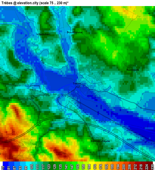
Below is the Elevation map of Trèbes, which displays elevation range with different colors. Scale of the first map is from 75 to 230 m (246 to 755 ft) with average elevation of 120.4 meters (=395 ft) [note 1]
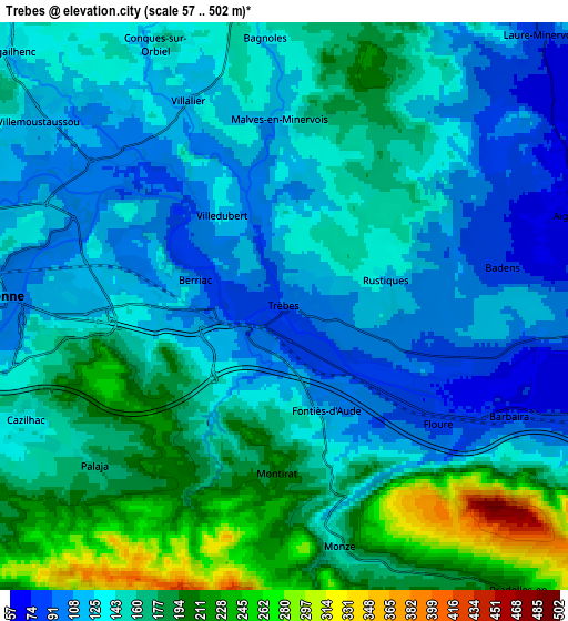
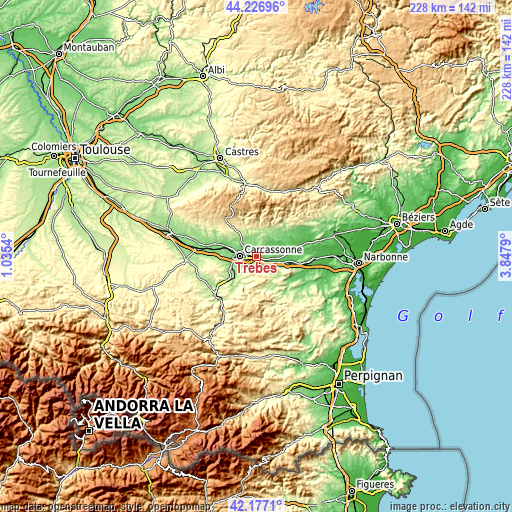
These maps also provides idea of topography and contour of this city, they are displayed at different zoom levels. More info about maps, scale and edge coordinates you can find below images.
| \ | Map #1 | Map #2 | Topo.Map |
| Scale [m] | 75..230 m | 57..502 m | × |
| Scale [ft] | 246..755 ft | 187..1647 ft | × |
| Average | 120.4 m = 395 ft | 150.4 m = 493 ft | × |
| Width | 7.12 km = 4.4 mi | 14.25 km = 8.9 mi | 227.9 km = 141.6 mi |
| Height | 7.12 km = 4.4 mi | 14.25 km = 8.9 mi | 227.9 km = 141.6 mi |
| ↑Max Latitude | 43.242661° | 43.274665° | 44.22696° |
| Latitude at center | 43.21064° | 43.21064° | 43.21064° |
| ↓Min Latitude | 43.178602° | 43.146548° | 42.1771° |
| ← Min Longitude | 2.397705° | 2.353759° | 1.0354° |
| Longitude center | 2.44165° | 2.44165° | 2.44165° |
| →Max Longitude | 2.485595° | 2.529541° | 3.8479° |
Nearby cities:
Cities around Trèbes sort by population:
• Carcassonne elevation 103 m
7.3 km,  272°
272°
• Villemoustaussou 115 m
7.7 km,  306°
306°
• Pennautier 117 m
10.7 km,  291°
291°
• Conques-sur-Orbiel 125 m
6.6 km,  342°
342°
• Rieux-Minervois 121 m
14.2 km,  56°
56°
• Palaja 178 m
6.2 km,  228°
228°
• Cazilhac 140 m
7.3 km,  244°
244°
• Capendu 77 m
9.7 km,  106°
106°
• Villegailhenc 130 m
9.6 km, 312°
• Laure-Minervois 87 m
9.3 km,  43°
43°
• Lavalette 187 m
14.4 km,  258°
258°
• Peyriac-Minervois 138 m
13.4 km,  48°
48°
Multilingual:
 En español:
Trèbes elevación 94 m.
 En France:
Trèbes élévation 94 m.


Sources and notes:
- [note 1] Map square and city borders are not equal. Map elevation data is calculated only from area inside that square.
- [src 1] Elevation data from geonames database provided with same terms of usage.
- [src 2] The elevation map of Trèbes is generated using elevation data from NASA's 3 arcsec (90m) resolution SRTM data.
- [src 3] Base (background) map © OpenStreetMap contributors tiles are generated by Geofabrik and OpenTopoMap.
Copyright & License:
This Trèbes Elevation Map is licensed under CC BY-SA. You may reuse any part from this page, if you give a proper credit by linking to this URL:
 More info on terms of use page.