Laure-Minervois elevation
Laure-Minervois (Occitanie, Département de l'Aude), France elevation is 87 meters and Laure-Minervois elevation in feet is 285 ft above sea level [src 1]. Laure-Minervois is a populated place (feature code) with elevation that is 87 meters (285 ft) smaller than average city elevation in France.
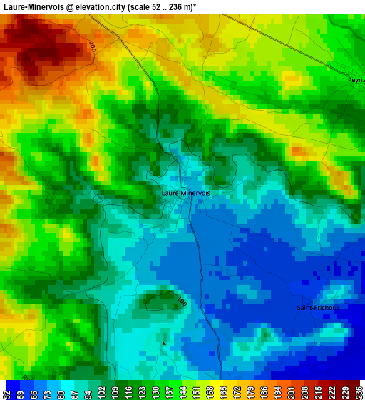
Below is the Elevation map of Laure-Minervois, which displays elevation range with different colors. Scale of the first map is from 52 to 236 m (171 to 774 ft) with average elevation of 119.4 meters (=392 ft) [note 1]
These maps also provides idea of topography and contour of this city, they are displayed at different zoom levels. More info about maps, scale and edge coordinates you can find below images.
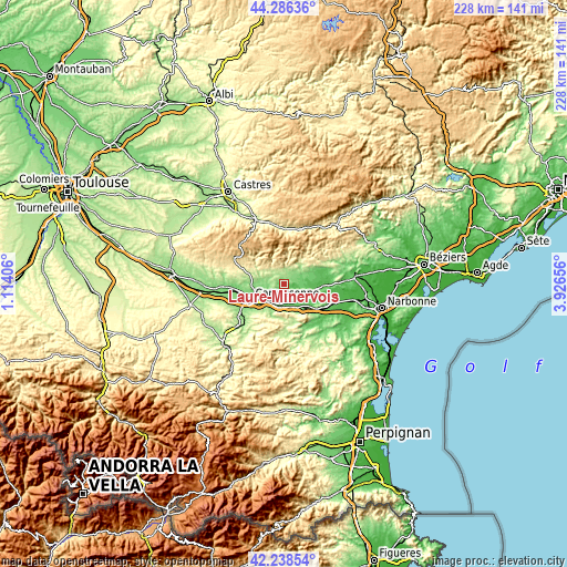
| \ | Map #1 | Topo.Map |
| Scale [m] | 52..236 m | × |
| Scale [ft] | 171..774 ft | × |
| Average | 119.4 m = 392 ft | × |
| Width | 7.12 km = 4.4 mi | 227.7 km = 141.5 mi |
| Height | 7.12 km = 4.4 mi | 227.7 km = 141.5 mi |
| ↑Max Latitude | 43.303049° | 44.28636° |
| Latitude at center | 43.27106° | 43.27106° |
| ↓Min Latitude | 43.239054° | 42.23854° |
| ← Min Longitude | 2.476365° | 1.11406° |
| Longitude center | 2.52031° | 2.52031° |
| →Max Longitude | 2.564255° | 3.92656° |
Nearby cities:
Cities around Laure-Minervois sort by population:
• Carcassonne elevation 103 m
15.1 km,  244°
244°
• Trèbes 94 m
9.3 km,  223°
223°
• Villemoustaussou 115 m
12.7 km,  260°
260°
• Conques-sur-Orbiel 125 m
8.4 km,  266°
266°
• Rieux-Minervois 121 m
5.5 km,  77°
77°
• Caunes-Minervois 186 m
6.1 km,  3°
3°
• Capendu 77 m
9.9 km,  162°
162°
• Villegailhenc 130 m
13.4 km, 268°
• Puicheric 64 m
9.9 km,  121°
121°
• Azille 90 m
11.3 km,  86°
86°
• Pépieux 89 m
13.2 km, 77°
• Peyriac-Minervois 138 m
4.3 km,  59°
59°
Multilingual:
 En español:
Laure-Minervois elevación 87 m.
 En France:
Laure-Minervois élévation 87 m.
 Auf Deutsch:
Laure-Minervois höhe über dem Meeresspiegel ist 87 m.

Sources and notes:
- [note 1] Map square and city borders are not equal. Map elevation data is calculated only from area inside that square.
- [src 1] Elevation data from geonames database provided with same terms of usage.
- [src 2] The elevation map of Laure-Minervois is generated using elevation data from NASA's 3 arcsec (90m) resolution SRTM data.
- [src 3] Base (background) map © OpenStreetMap contributors tiles are generated by Geofabrik and OpenTopoMap.
Copyright & License:
This Laure-Minervois Elevation Map is licensed under CC BY-SA. You may reuse any part from this page, if you give a proper credit by linking to this URL:
 More info on terms of use page.