Carlepont elevation
Carlepont (Hauts-de-France, Département de l'Oise), France elevation is 56 meters and Carlepont elevation in feet is 184 ft above sea level [src 1]. Carlepont is a populated place (feature code) with elevation that is 118 meters (387 ft) smaller than average city elevation in France.
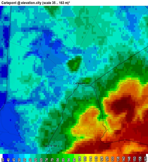
Below is the Elevation map of Carlepont, which displays elevation range with different colors. Scale of the first map is from 35 to 163 m (115 to 535 ft) with average elevation of 73.9 meters (=242 ft) [note 1]
These maps also provides idea of topography and contour of this city, they are displayed at different zoom levels. More info about maps, scale and edge coordinates you can find below images.
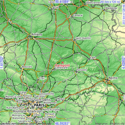
| \ | Map #1 | Topo.Map |
| Scale [m] | 35..163 m | × |
| Scale [ft] | 115..535 ft | × |
| Average | 73.9 m = 242 ft | × |
| Width | 6.34 km = 3.9 mi | 203 km = 126.1 mi |
| Height | 6.34 km = 3.9 mi | 203 km = 126.1 mi |
| ↑Max Latitude | 49.542903° | 50.41889° |
| Latitude at center | 49.51438° | 49.51438° |
| ↓Min Latitude | 49.48584° | 48.59283° |
| ← Min Longitude | 2.979325° | 1.61702° |
| Longitude center | 3.02327° | 3.02327° |
| →Max Longitude | 3.067215° | 4.42952° |
Nearby cities:
Cities around Carlepont sort by population:
• Noyon elevation 52 m
7.8 km,  347°
347°
• Thourotte 35 m
11.1 km,  247°
247°
• Dreslincourt 71 m
7.1 km,  282°
282°
• Longueil-Annel 34 m
12.5 km, 246°
• Cambronne-lès-Ribécourt 68 m
9.1 km,  264°
264°
• Attichy 42 m
11.6 km,  170°
170°
• Tracy-le-Mont 112 m
4.8 km,  192°
192°
• Le Plessis-Brion 35 m
11.1 km,  239°
239°
• Blérancourt 69 m
9.2 km,  88°
88°
• Chiry-Ourscamp 63 m
6.4 km,  300°
300°
• Montmacq 35 m
9.4 km, 247°
• Crisolles 76 m
12 km,  356°
356°
Multilingual:
 En español:
Carlepont elevación 56 m.
 En France:
Carlepont élévation 56 m.
 Auf Deutsch:
Carlepont höhe über dem Meeresspiegel ist 56 m.

Sources and notes:
- [note 1] Map square and city borders are not equal. Map elevation data is calculated only from area inside that square.
- [src 1] Elevation data from geonames database provided with same terms of usage.
- [src 2] The elevation map of Carlepont is generated using elevation data from NASA's 3 arcsec (90m) resolution SRTM data.
- [src 3] Base (background) map © OpenStreetMap contributors tiles are generated by Geofabrik and OpenTopoMap.
Copyright & License:
This Carlepont Elevation Map is licensed under CC BY-SA. You may reuse any part from this page, if you give a proper credit by linking to this URL:
 More info on terms of use page.