Montmacq elevation
Montmacq (Hauts-de-France, Département de l'Oise), France elevation is 35 meters and Montmacq elevation in feet is 115 ft above sea level [src 1]. Montmacq is a populated place (feature code) with elevation that is 139 meters (456 ft) smaller than average city elevation in France.
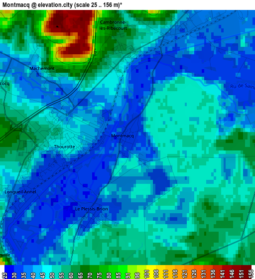
Below is the Elevation map of Montmacq, which displays elevation range with different colors. Scale of the first map is from 25 to 156 m (82 to 512 ft) with average elevation of 49.7 meters (=163 ft) [note 1]
These maps also provides idea of topography and contour of this city, they are displayed at different zoom levels. More info about maps, scale and edge coordinates you can find below images.
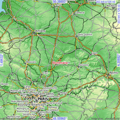
| \ | Map #1 | Topo.Map |
| Scale [m] | 25..156 m | × |
| Scale [ft] | 82..512 ft | × |
| Average | 49.7 m = 163 ft | × |
| Width | 6.35 km = 3.9 mi | 203.2 km = 126.3 mi |
| Height | 6.35 km = 3.9 mi | 203.2 km = 126.3 mi |
| ↑Max Latitude | 49.510352° | 50.38693° |
| Latitude at center | 49.48181° | 49.48181° |
| ↓Min Latitude | 49.453251° | 48.55965° |
| ← Min Longitude | 2.858625° | 1.49632° |
| Longitude center | 2.90257° | 2.90257° |
| →Max Longitude | 2.946515° | 4.30882° |
Nearby cities:
Cities around Montmacq sort by population:
• Margny-lès-Compiègne elevation 33 m
8.7 km,  224°
224°
• Thourotte 35 m
1.6 km,  246°
246°
• Dreslincourt 71 m
5.4 km,  18°
18°
• Choisy-au-Bac 38 m
5.2 km,  200°
200°
• Longueil-Annel 34 m
3.1 km,  242°
242°
• Clairoix 37 m
6 km, 223°
• Cambronne-lès-Ribécourt 68 m
2.8 km,  353°
353°
• Tracy-le-Mont 112 m
7.8 km,  97°
97°
• Le Plessis-Brion 35 m
2.1 km, 203°
• Villers-sur-Coudun 77 m
7.1 km,  271°
271°
• Chiry-Ourscamp 63 m
7.6 km,  25°
25°
• Coudun 43 m
6.9 km, 250°
Multilingual:
 En español:
Montmacq elevación 35 m.
 En France:
Montmacq élévation 35 m.


Sources and notes:
- [note 1] Map square and city borders are not equal. Map elevation data is calculated only from area inside that square.
- [src 1] Elevation data from geonames database provided with same terms of usage.
- [src 2] The elevation map of Montmacq is generated using elevation data from NASA's 3 arcsec (90m) resolution SRTM data.
- [src 3] Base (background) map © OpenStreetMap contributors tiles are generated by Geofabrik and OpenTopoMap.
Copyright & License:
This Montmacq Elevation Map is licensed under CC BY-SA. You may reuse any part from this page, if you give a proper credit by linking to this URL:
 More info on terms of use page.