Noyon elevation
Noyon (Hauts-de-France, Département de l'Oise), France elevation is 52 meters and Noyon elevation in feet is 171 ft above sea level [src 1]. Noyon is a populated place (feature code) with elevation that is 122 meters (400 ft) smaller than average city elevation in France.
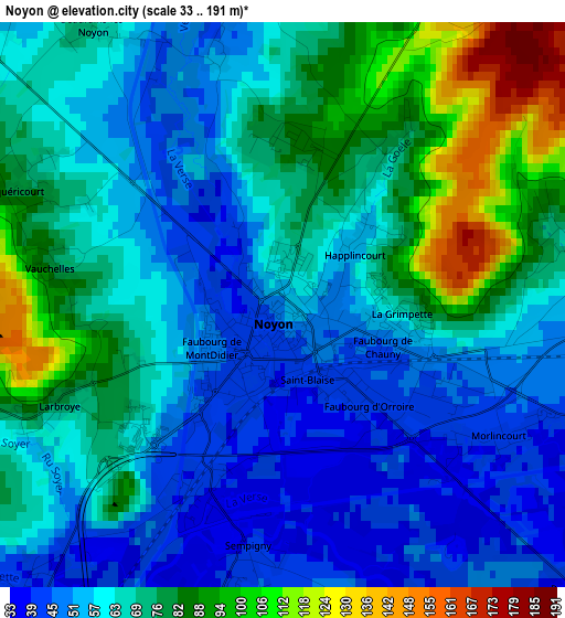
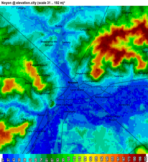
Below is the Elevation map of Noyon, which displays elevation range with different colors. Scale of the first map is from 33 to 191 m (108 to 627 ft) with average elevation of 67.2 meters (=220 ft) [note 1]
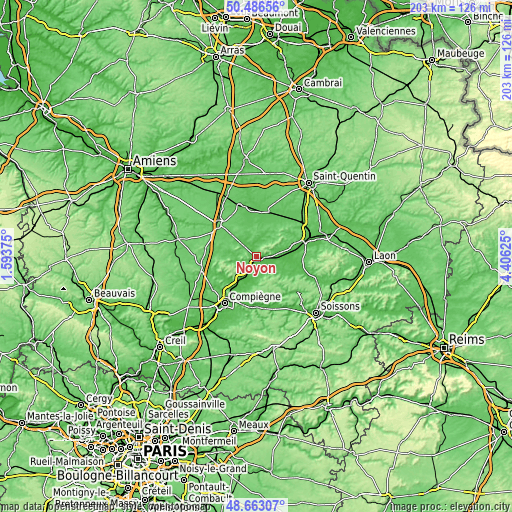
These maps also provides idea of topography and contour of this city, they are displayed at different zoom levels. More info about maps, scale and edge coordinates you can find below images.
| \ | Map #1 | Map #2 | Topo.Map |
| Scale [m] | 33..191 m | 31..192 m | × |
| Scale [ft] | 108..627 ft | 102..630 ft | × |
| Average | 67.2 m = 220 ft | 73.1 m = 240 ft | × |
| Width | 6.34 km = 3.9 mi | 12.67 km = 7.9 mi | 202.8 km = 126 mi |
| Height | 6.34 km = 3.9 mi | 12.67 km = 7.9 mi | 202.7 km = 126 mi |
| ↑Max Latitude | 49.611813° | 49.64028° | 50.48656° |
| Latitude at center | 49.58333° | 49.58333° | 49.58333° |
| ↓Min Latitude | 49.55483° | 49.526314° | 48.66307° |
| ← Min Longitude | 2.956055° | 2.912109° | 1.59375° |
| Longitude center | 3° | 3° | 3° |
| →Max Longitude | 3.043945° | 3.087891° | 4.40625° |
Nearby cities:
Cities around Noyon sort by population:
• Thourotte elevation 35 m
14.7 km,  215°
215°
• Dreslincourt 71 m
8.1 km, 220°
• Cambronne-lès-Ribécourt 68 m
11.2 km, 220°
• Guiscard 62 m
8.9 km,  24°
24°
• Tracy-le-Mont 112 m
12.4 km,  176°
176°
• Carlepont 56 m
7.8 km,  167°
167°
• Lassigny 65 m
11.3 km,  272°
272°
• Blérancourt 69 m
13.1 km,  124°
124°
• Chiry-Ourscamp 63 m
5.8 km, 220°
• Montmacq 35 m
13.3 km,  211°
211°
• Ognes 57 m
14.3 km,  76°
76°
• Crisolles 76 m
4.5 km,  13°
13°
Multilingual:
 En español:
Noyon elevación 52 m.
 En France:
Noyon élévation 52 m.


Sources and notes:
- [note 1] Map square and city borders are not equal. Map elevation data is calculated only from area inside that square.
- [src 1] Elevation data from geonames database provided with same terms of usage.
- [src 2] The elevation map of Noyon is generated using elevation data from NASA's 3 arcsec (90m) resolution SRTM data.
- [src 3] Base (background) map © OpenStreetMap contributors tiles are generated by Geofabrik and OpenTopoMap.
Copyright & License:
This Noyon Elevation Map is licensed under CC BY-SA. You may reuse any part from this page, if you give a proper credit by linking to this URL:
 More info on terms of use page.