Colmar elevation
Colmar (Grand Est, Haut-Rhin), France elevation is 190 meters and Colmar elevation in feet is 623 ft above sea level [src 1]. Colmar is a seat of a second-order administrative division (feature code) with elevation that is 16 meters (52 ft) bigger than average city elevation in France.
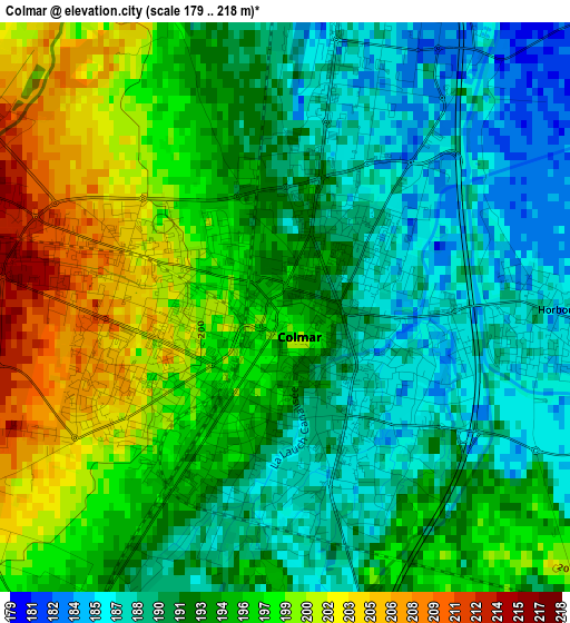
Below is the Elevation map of Colmar, which displays elevation range with different colors. Scale of the first map is from 179 to 218 m (587 to 715 ft) with average elevation of 193.3 meters (=634 ft) [note 1]
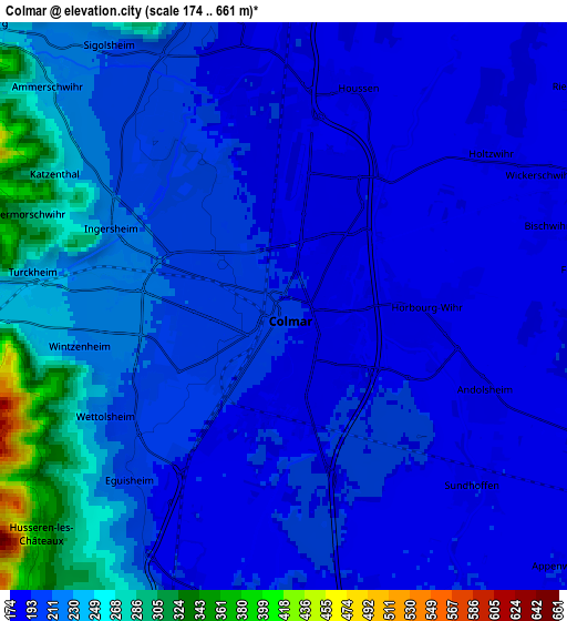
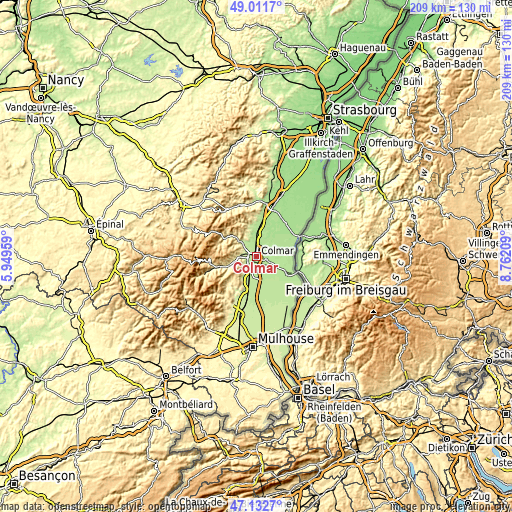
These maps also provides idea of topography and contour of this city, they are displayed at different zoom levels. More info about maps, scale and edge coordinates you can find below images.
| \ | Map #1 | Map #2 | Topo.Map |
| Scale [m] | 179..218 m | 174..661 m | × |
| Scale [ft] | 587..715 ft | 571..2169 ft | × |
| Average | 193.3 m = 634 ft | 211.6 m = 694 ft | × |
| Width | 6.53 km = 4.1 mi | 13.06 km = 8.1 mi | 208.9 km = 129.8 mi |
| Height | 6.53 km = 4.1 mi | 13.06 km = 8.1 mi | 208.9 km = 129.8 mi |
| ↑Max Latitude | 48.110131° | 48.139465° | 49.0117° |
| Latitude at center | 48.08078° | 48.08078° | 48.08078° |
| ↓Min Latitude | 48.051413° | 48.022028° | 47.1327° |
| ← Min Longitude | 7.311895° | 7.267949° | 5.94959° |
| Longitude center | 7.35584° | 7.35584° | 7.35584° |
| →Max Longitude | 7.399785° | 7.443731° | 8.76209° |
Nearby cities:
Cities around Colmar sort by population:
• Wintzenheim elevation 230 m
4.9 km,  259°
259°
• Horbourg-Wihr 188 m
2.8 km,  89°
89°
• Ingersheim 217 m
4.4 km,  296°
296°
• Turckheim 240 m
5.9 km,  277°
277°
• Andolsheim 189 m
5 km,  115°
115°
• Sundhoffen 193 m
6 km,  134°
134°
• Wettolsheim 222 m
5 km,  238°
238°
• Houssen 183 m
5.3 km,  17°
17°
• Herrlisheim-près-Colmar 193 m
7.3 km,  197°
197°
• Eguisheim 210 m
5.6 km,  221°
221°
• Holtzwihr 180 m
6 km,  53°
53°
• Fortschwihr 186 m
7.1 km,  83°
83°
Multilingual:
 En español:
Colmar elevación 190 m.
 En France:
Colmar élévation 190 m.


Sources and notes:
- [note 1] Map square and city borders are not equal. Map elevation data is calculated only from area inside that square.
- [src 1] Elevation data from geonames database provided with same terms of usage.
- [src 2] The elevation map of Colmar is generated using elevation data from NASA's 3 arcsec (90m) resolution SRTM data.
- [src 3] Base (background) map © OpenStreetMap contributors tiles are generated by Geofabrik and OpenTopoMap.
Copyright & License:
This Colmar Elevation Map is licensed under CC BY-SA. You may reuse any part from this page, if you give a proper credit by linking to this URL:
 More info on terms of use page.