Craponne-sur-Arzon elevation
Craponne-sur-Arzon (Auvergne-Rhône-Alpes, Haute-Loire), France elevation is 920 meters and Craponne-sur-Arzon elevation in feet is 3018 ft above sea level [src 1]. Craponne-sur-Arzon is a populated place (feature code) with elevation that is 746 meters (2448 ft) bigger than average city elevation in France.
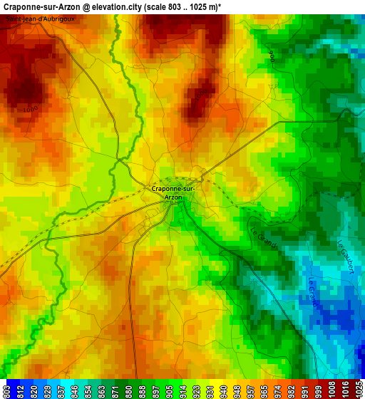
Below is the Elevation map of Craponne-sur-Arzon, which displays elevation range with different colors. Scale of the first map is from 803 to 1025 m (2635 to 3363 ft) with average elevation of 927.3 meters (=3042 ft) [note 1]
These maps also provides idea of topography and contour of this city, they are displayed at different zoom levels. More info about maps, scale and edge coordinates you can find below images.
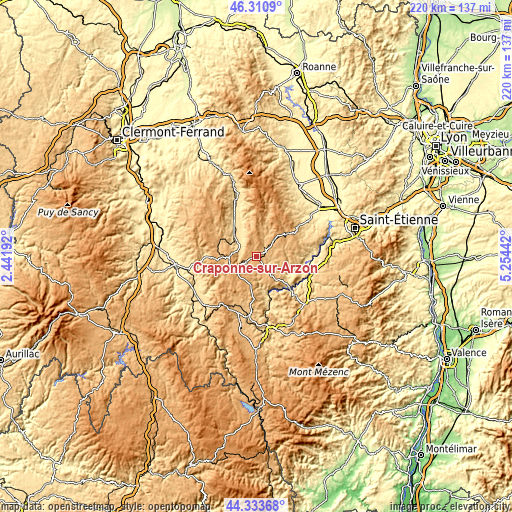
| \ | Map #1 | Topo.Map |
| Scale [m] | 803..1025 m | × |
| Scale [ft] | 2635..3363 ft | × |
| Average | 927.3 m = 3042 ft | × |
| Width | 6.87 km = 4.3 mi | 219.8 km = 136.6 mi |
| Height | 6.87 km = 4.3 mi | 219.8 km = 136.6 mi |
| ↑Max Latitude | 45.361806° | 46.3109° |
| Latitude at center | 45.33092° | 45.33092° |
| ↓Min Latitude | 45.300018° | 44.33368° |
| ← Min Longitude | 3.804225° | 2.44192° |
| Longitude center | 3.84817° | 3.84817° |
| →Max Longitude | 3.892115° | 5.25442° |
Nearby cities:
Cities around Craponne-sur-Arzon sort by population:
• Bas-en-Basset elevation 465 m
20.6 km,  97°
97°
• Retournac 523 m
20.2 km,  134°
134°
• Saint-Paulien 814 m
21.8 km,  187°
187°
• Beauzac 554 m
21.2 km,  112°
112°
• Arlanc 609 m
13.3 km,  313°
313°
• Saint-Bonnet-le-Château 875 m
20 km,  58°
58°
• Vorey 549 m
16.8 km,  163°
163°
• Marsac-en-Livradois 544 m
18.9 km,  330°
330°
• Rosières 654 m
24.6 km,  153°
153°
• Fontannes 1035 m
7.4 km,  243°
243°
• Usson-en-Forez 929 m
9.9 km,  47°
47°
• Allègre 1055 m
18.1 km,  216°
216°
Multilingual:
 En español:
Craponne-sur-Arzon elevación 920 m.
 En France:
Craponne-sur-Arzon élévation 920 m.
 Auf Deutsch:
Craponne-sur-Arzon höhe über dem Meeresspiegel ist 920 m.
 На русском:
Craponne-sur-Arzon высота над уровнем моря 920 м
Sources and notes:
- [note 1] Map square and city borders are not equal. Map elevation data is calculated only from area inside that square.
- [src 1] Elevation data from geonames database provided with same terms of usage.
- [src 2] The elevation map of Craponne-sur-Arzon is generated using elevation data from NASA's 3 arcsec (90m) resolution SRTM data.
- [src 3] Base (background) map © OpenStreetMap contributors tiles are generated by Geofabrik and OpenTopoMap.
Copyright & License:
This Craponne-sur-Arzon Elevation Map is licensed under CC BY-SA. You may reuse any part from this page, if you give a proper credit by linking to this URL:
 More info on terms of use page.