Vorey elevation
Vorey (Auvergne-Rhône-Alpes, Haute-Loire), France elevation is 549 meters and Vorey elevation in feet is 1801 ft above sea level [src 1]. Vorey is a populated place (feature code) with elevation that is 375 meters (1230 ft) bigger than average city elevation in France.
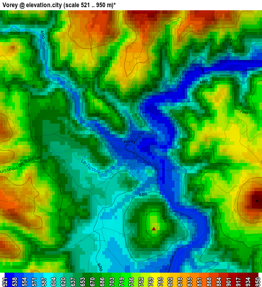
Below is the Elevation map of Vorey, which displays elevation range with different colors. Scale of the first map is from 521 to 950 m (1709 to 3117 ft) with average elevation of 684.1 meters (=2244 ft) [note 1]
These maps also provides idea of topography and contour of this city, they are displayed at different zoom levels. More info about maps, scale and edge coordinates you can find below images.
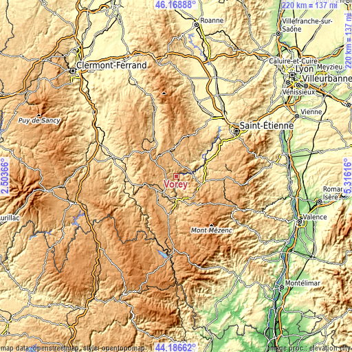
| \ | Map #1 | Topo.Map |
| Scale [m] | 521..950 m | × |
| Scale [ft] | 1709..3117 ft | × |
| Average | 684.1 m = 2244 ft | × |
| Width | 6.89 km = 4.3 mi | 220.4 km = 136.9 mi |
| Height | 6.89 km = 4.3 mi | 220.4 km = 136.9 mi |
| ↑Max Latitude | 45.217344° | 46.16888° |
| Latitude at center | 45.18638° | 45.18638° |
| ↓Min Latitude | 45.155399° | 44.18662° |
| ← Min Longitude | 3.865965° | 2.50366° |
| Longitude center | 3.90991° | 3.90991° |
| →Max Longitude | 3.953855° | 5.31616° |
Nearby cities:
Cities around Vorey sort by population:
• Le Puy-en-Velay elevation 640 m
16 km,  186°
186°
• Brives-Charensac 610 m
15.5 km,  174°
174°
• Espaly-Saint-Marcel 639 m
15.8 km, 192°
• Chadrac 643 m
13.9 km,  182°
182°
• Craponne-sur-Arzon 920 m
16.8 km,  343°
343°
• Polignac 751 m
13.4 km,  196°
196°
• Retournac 523 m
9.9 km,  78°
78°
• Beauzac 554 m
16.9 km,  61°
61°
• Saint-Paulien 814 m
9.4 km,  233°
233°
• Blavozy 703 m
15.4 km,  159°
159°
• Rosières 654 m
8.6 km,  134°
134°
• Allègre 1055 m
15.6 km,  275°
275°
Multilingual:
 En español:
Vorey elevación 549 m.
 En France:
Vorey élévation 549 m.


Sources and notes:
- [note 1] Map square and city borders are not equal. Map elevation data is calculated only from area inside that square.
- [src 1] Elevation data from geonames database provided with same terms of usage.
- [src 2] The elevation map of Vorey is generated using elevation data from NASA's 3 arcsec (90m) resolution SRTM data.
- [src 3] Base (background) map © OpenStreetMap contributors tiles are generated by Geofabrik and OpenTopoMap.
Copyright & License:
This Vorey Elevation Map is licensed under CC BY-SA. You may reuse any part from this page, if you give a proper credit by linking to this URL:
 More info on terms of use page.