Die elevation
Die (Auvergne-Rhône-Alpes, Département de la Drôme), France elevation is 425 meters and Die elevation in feet is 1394 ft above sea level [src 1]. Die is a seat of a third-order administrative division (feature code) with elevation that is 251 meters (823 ft) bigger than average city elevation in France.
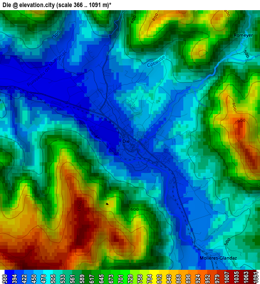
Below is the Elevation map of Die, which displays elevation range with different colors. Scale of the first map is from 366 to 1091 m (1201 to 3579 ft) with average elevation of 589.6 meters (=1934 ft) [note 1]
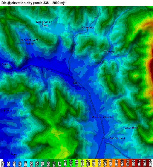
These maps also provides idea of topography and contour of this city, they are displayed at different zoom levels. More info about maps, scale and edge coordinates you can find below images.
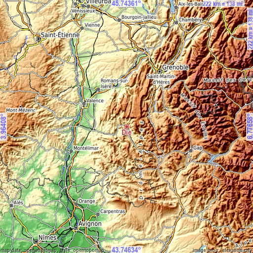
| \ | Map #1 | Map #2 | Topo.Map |
| Scale [m] | 366..1091 m | 338..2000 m | × |
| Scale [ft] | 1201..3579 ft | 1109..6562 ft | × |
| Average | 589.6 m = 1934 ft | 702.7 m = 2305 ft | × |
| Width | 6.94 km = 4.3 mi | 13.88 km = 8.6 mi | 222.1 km = 138 mi |
| Height | 6.94 km = 4.3 mi | 13.88 km = 8.6 mi | 222.1 km = 138 mi |
| ↑Max Latitude | 44.784799° | 44.815981° | 45.74361° |
| Latitude at center | 44.7536° | 44.7536° | 44.7536° |
| ↓Min Latitude | 44.722384° | 44.691152° | 43.74634° |
| ← Min Longitude | 5.326385° | 5.282439° | 3.96408° |
| Longitude center | 5.37033° | 5.37033° | 5.37033° |
| →Max Longitude | 5.414275° | 5.458221° | 6.77658° |
Nearby cities:
Cities around Die sort by population:
• Crest elevation 186 m
28.2 km,  263°
263°
• Chabeuil 214 m
32.4 km,  299°
299°
• Montélier 222 m
33.4 km,  306°
306°
• Saint-Jean-en-Royans 280 m
30.2 km,  348°
348°
• Montmeyran 199 m
32.7 km,  285°
285°
• Aouste-sur-Sye 229 m
25.3 km, 261°
• Montoison 183 m
34.2 km,  277°
277°
• Saint-Laurent-en-Royans 388 m
30.5 km, 353°
• Mens 868 m
30.9 km,  77°
77°
• Upie 223 m
31.5 km, 279°
• Eurre 242 m
30.2 km,  270°
270°
• Pont-en-Royans 266 m
34.4 km,  356°
356°
Multilingual:
 En español:
Die elevación 425 m.
 En France:
Die élévation 425 m.


Sources and notes:
- [note 1] Map square and city borders are not equal. Map elevation data is calculated only from area inside that square.
- [src 1] Elevation data from geonames database provided with same terms of usage.
- [src 2] The elevation map of Die is generated using elevation data from NASA's 3 arcsec (90m) resolution SRTM data.
- [src 3] Base (background) map © OpenStreetMap contributors tiles are generated by Geofabrik and OpenTopoMap.
Copyright & License:
This Die Elevation Map is licensed under CC BY-SA. You may reuse any part from this page, if you give a proper credit by linking to this URL:
 More info on terms of use page.