Crest elevation
Crest (Auvergne-Rhône-Alpes, Département de la Drôme), France elevation is 186 meters and Crest elevation in feet is 610 ft above sea level [src 1]. Crest is a populated place (feature code) with elevation that is 12 meters (39 ft) bigger than average city elevation in France.
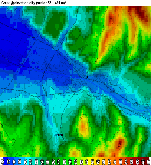
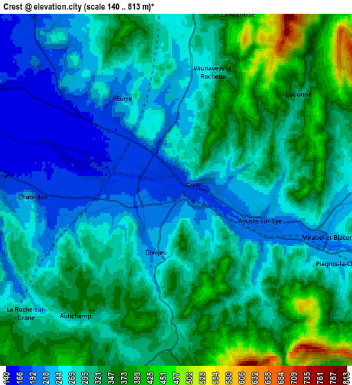
Below is the Elevation map of Crest, which displays elevation range with different colors. Scale of the first map is from 158 to 461 m (518 to 1512 ft) with average elevation of 245.3 meters (=805 ft) [note 1]
These maps also provides idea of topography and contour of this city, they are displayed at different zoom levels. More info about maps, scale and edge coordinates you can find below images.
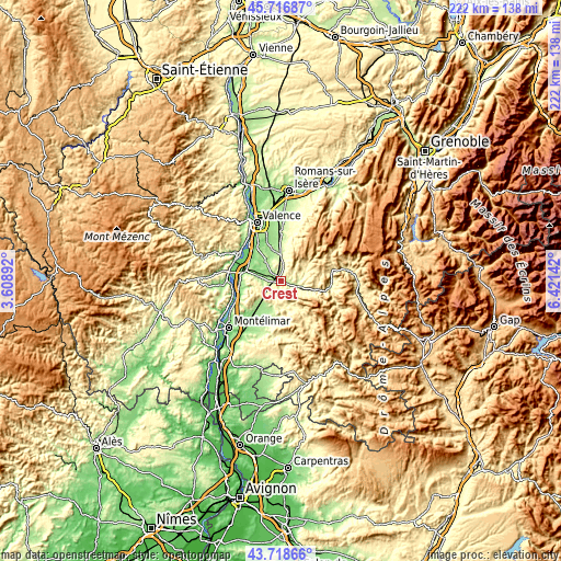
| \ | Map #1 | Map #2 | Topo.Map |
| Scale [m] | 158..461 m | 140..813 m | × |
| Scale [ft] | 518..1512 ft | 459..2667 ft | × |
| Average | 245.3 m = 805 ft | 294.9 m = 968 ft | × |
| Width | 6.94 km = 4.3 mi | 13.89 km = 8.6 mi | 222.2 km = 138.1 mi |
| Height | 6.94 km = 4.3 mi | 13.89 km = 8.6 mi | 222.2 km = 138.1 mi |
| ↑Max Latitude | 44.757604° | 44.7888° | 45.71687° |
| Latitude at center | 44.72639° | 44.72639° | 44.72639° |
| ↓Min Latitude | 44.69516° | 44.663912° | 43.71866° |
| ← Min Longitude | 4.971225° | 4.927279° | 3.60892° |
| Longitude center | 5.01517° | 5.01517° | 5.01517° |
| →Max Longitude | 5.059115° | 5.103061° | 6.42142° |
Nearby cities:
Cities around Crest sort by population:
• Livron-sur-Drôme elevation 124 m
14.8 km,  292°
292°
• Loriol-sur-Drôme 185 m
15.8 km,  278°
278°
• Étoile-sur-Rhône 180 m
15.9 km,  321°
321°
• Montmeyran 199 m
12.4 km,  344°
344°
• Allex 150 m
10.3 km,  296°
296°
• Aouste-sur-Sye 229 m
3.2 km,  106°
106°
• Montéléger 167 m
15.4 km, 336°
• Grane 178 m
7.4 km, 275°
• Montoison 183 m
9.7 km, 322°
• Upie 223 m
9 km, 340°
• Eurre 242 m
4.1 km,  329°
329°
• Marsanne 195 m
14.5 km,  229°
229°
Multilingual:
 En español:
Crest elevación 186 m.
 En France:
Crest élévation 186 m.


Sources and notes:
- [note 1] Map square and city borders are not equal. Map elevation data is calculated only from area inside that square.
- [src 1] Elevation data from geonames database provided with same terms of usage.
- [src 2] The elevation map of Crest is generated using elevation data from NASA's 3 arcsec (90m) resolution SRTM data.
- [src 3] Base (background) map © OpenStreetMap contributors tiles are generated by Geofabrik and OpenTopoMap.
Copyright & License:
This Crest Elevation Map is licensed under CC BY-SA. You may reuse any part from this page, if you give a proper credit by linking to this URL:
 More info on terms of use page.