Donzère elevation
Donzère (Auvergne-Rhône-Alpes, Département de la Drôme), France elevation is 115 meters and Donzère elevation in feet is 377 ft above sea level [src 1]. Donzère is a populated place (feature code) with elevation that is 59 meters (194 ft) smaller than average city elevation in France.
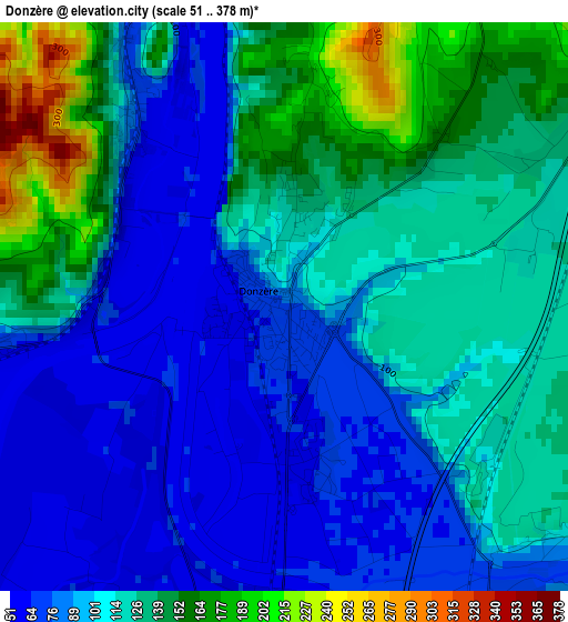
Below is the Elevation map of Donzère, which displays elevation range with different colors. Scale of the first map is from 51 to 378 m (167 to 1240 ft) with average elevation of 110.7 meters (=363 ft) [note 1]
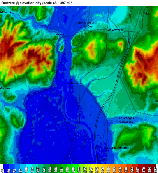
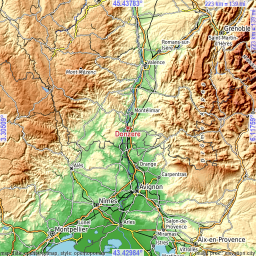
These maps also provides idea of topography and contour of this city, they are displayed at different zoom levels. More info about maps, scale and edge coordinates you can find below images.
| \ | Map #1 | Map #2 | Topo.Map |
| Scale [m] | 51..378 m | 46..397 m | × |
| Scale [ft] | 167..1240 ft | 151..1302 ft | × |
| Average | 110.7 m = 363 ft | 132.2 m = 434 ft | × |
| Width | 6.98 km = 4.3 mi | 13.95 km = 8.7 mi | 223.3 km = 138.8 mi |
| Height | 6.98 km = 4.3 mi | 13.95 km = 8.7 mi | 223.3 km = 138.8 mi |
| ↑Max Latitude | 44.473827° | 44.505176° | 45.43783° |
| Latitude at center | 44.44246° | 44.44246° | 44.44246° |
| ↓Min Latitude | 44.411077° | 44.379676° | 43.42984° |
| ← Min Longitude | 4.667395° | 4.623449° | 3.30509° |
| Longitude center | 4.71134° | 4.71134° | 4.71134° |
| →Max Longitude | 4.755285° | 4.799231° | 6.11759° |
Nearby cities:
Cities around Donzère sort by population:
• Montélimar elevation 86 m
12.9 km,  15°
15°
• Pierrelatte 55 m
7.5 km,  184°
184°
• Le Teil 67 m
11.7 km,  348°
348°
• Bourg-Saint-Andéol 52 m
9.4 km,  214°
214°
• Saint-Paul-Trois-Châteaux 98 m
11.5 km,  158°
158°
• Viviers 60 m
4.8 km,  338°
338°
• Châteauneuf-du-Rhône 113 m
5.2 km,  5°
5°
• Montboucher-sur-Jabron 125 m
14 km,  30°
30°
• Allan 192 m
8.8 km,  46°
46°
• Malataverne 128 m
5.8 km, 34°
• La Garde-Adhémar 170 m
6.2 km,  144°
144°
• Montségur-sur-Lauzon 145 m
14.6 km,  128°
128°
Multilingual:
 En español:
Donzère elevación 115 m.
 En France:
Donzère élévation 115 m.


Sources and notes:
- [note 1] Map square and city borders are not equal. Map elevation data is calculated only from area inside that square.
- [src 1] Elevation data from geonames database provided with same terms of usage.
- [src 2] The elevation map of Donzère is generated using elevation data from NASA's 3 arcsec (90m) resolution SRTM data.
- [src 3] Base (background) map © OpenStreetMap contributors tiles are generated by Geofabrik and OpenTopoMap.
Copyright & License:
This Donzère Elevation Map is licensed under CC BY-SA. You may reuse any part from this page, if you give a proper credit by linking to this URL:
 More info on terms of use page.